


The monsoon rains that typically pour down on India starting in June are generally welcomed by farmers. But for people who live in or near river floodplains, the monsoon can be deadly. Through August 2016, monsoon-fueled floods reportedly killed hundreds of people across several states in India and caused the evacuation of hundreds of thousands more.
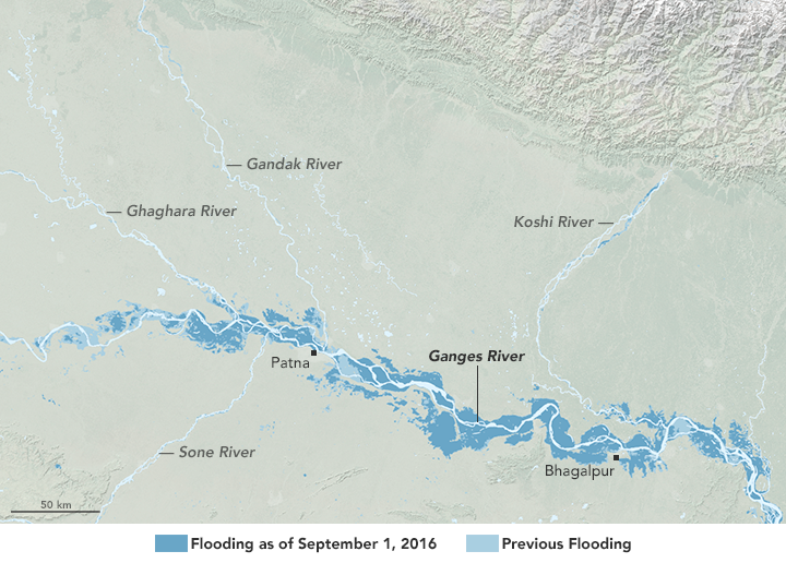
The map above shows part of the flooded Ganges and its tributaries in Bihar, a state in East India with a vast expanse of flat, fertile land. The lightest blue areas represent the location of relatively permanent water, based on data acquired in February 2000 by the Shuttle Radar Topography Mission. The two darker shades of blue around the rivers show areas that have been inundated with floodwater; the lighter blue color indicates areas previously flooded during this event, while the darker blue color indicates areas affected by more recent flooding (spanning a two-week period ending on September 1, 2016).
The floodwater data were acquired with the Moderate Resolution Imaging Spectroradiometer (MODIS) on NASA’s Aqua and Terra satellites. These data were initially mapped by the Dartmouth Flood Observatory at University of Colorado, a group that compiles remote-sensing data to produce near-real-time maps of flood events.
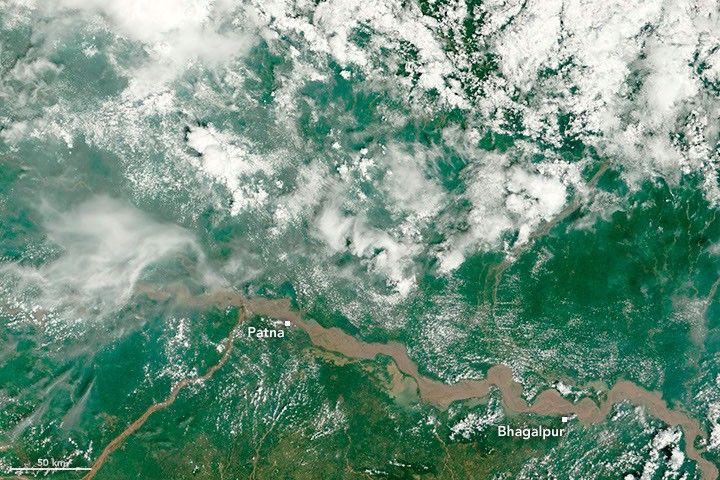
The second image, acquired with the MODIS on NASA’s Terra satellite, shows the river on August 30, 2016. In this true-color image, the Ganges and its tributaries appear brown. According to some experts, the huge amount of silt carried by the river might be partly to blame for the flooding. Silt that settles out of the moving water can raise the level of the riverbed, and block normal passages of flow.
La Niña has been known to enhance the Asian Monsoon and may have been a factor in shaping the intense monsoon and flooding in 2010. But according to news reports, La Niña in 2016 was not developing as expected, and the monsoon across India has been active but slightly below normal.
References & Resources
- BBC News (2016, August 30) India Ganges floods ‘break previous records’. Accessed September 9, 2016.
- Dartmouth Flood Observatory (2016, September 1) DFO Flood Event 4384. Accessed September 9, 2016.
- Hindustan Times (2016, August 25) It’s the season of flooding, but monsoon is below normal. Accessed September 9, 2016.
- The Weather Channel (2016, August 23) More Than 300 Killed, Hundreds of Thousands Evacuated as Monsoon Rains Flood India. Accessed September 9, 2016.
NASA Earth Observatory images by Joshua Stevens, using data from the Dartmouth Flood Observatory . Caption by Kathryn Hansen.


