


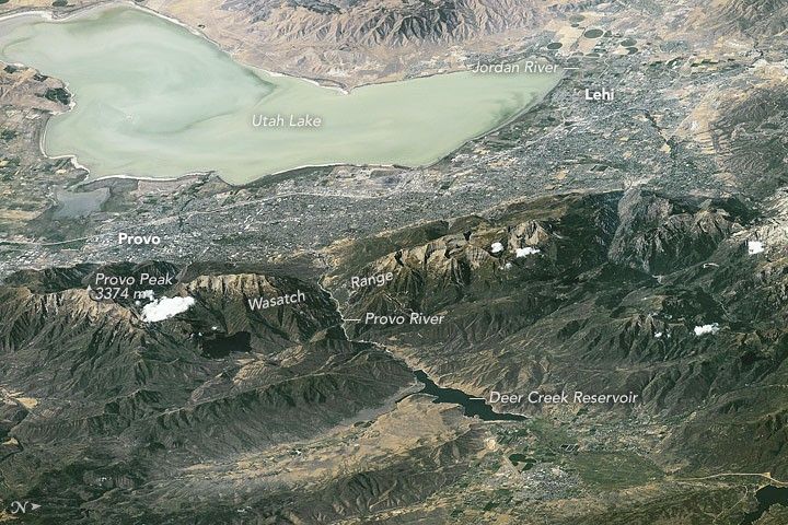
An astronaut aboard the International Space Station looked west from more than 700 kilometers (400 miles) away and focused an 800 millimeter lens on the shorelines of Utah Lake and other water bodies in Utah. Shorelines are easy to see from space and often indicate interesting centers of human activity.
Utah Lake is so shallow that surface waves stir up light-toned muds from the bottom, giving the lake a light green-blue hue. Across the middle of the image, gray tones show the Provo-Orem metropolitan area that fringes the length of the lake, which is 33 kilometers (20 miles) long. The lake’s only outlet is the Jordan River (right), which leads water to the Great Salt Lake (at times when Utah Lake stands high).
The Veterans Memorial Highway is a straight white line running through the metropolitan area from Provo to Lehi. Most of the green tones fringing the cities are farms that stretch right down to the water’s edge. The lower part of the image shows the thickly wooded Wasatch Range, which rises so high above the city that it captures rain. Provo Peak and Mount Timpanogos are two well-known local peaks.
Finding water for a population of 527,000 people and for local farming has always been problematic in Utah. Luckily snow and rainfall on the Wasatch Range nearby provide enough water—when there is careful conservation and reuse of water. The main water supplies come from wells and springs, as well as the reservoirs (such as Deer Creek) on the east side of the mountains.
References & Resources
Astronaut photograph ISS048-E-73267 was acquired on September 6, 2016, with a Nikon D4 digital camera using an 800 millimeter lens, and is provided by the ISS Crew Earth Observations Facility and the Earth Science and Remote Sensing Unit, Johnson Space Center. The image was taken by a member of the Expedition 48 crew. The image has been cropped and enhanced to improve contrast, and lens artifacts have been removed. The International Space Station Program supports the laboratory as part of the ISS National Lab to help astronauts take pictures of Earth that will be of the greatest value to scientists and the public, and to make those images freely available on the Internet. Additional images taken by astronauts and cosmonauts can be viewed at the NASA/JSC Gateway to Astronaut Photography of Earth. Caption by M. Justin Wilkinson, Texas State University, Jacobs Contract at NASA-JSC.


