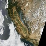
Wildfire struck the rugged woodlands near Yosemite National Park in mid-July 2017, causing sporadic evacuations of nearby towns and spreading a pall of smoke as far as Idaho. As of July 21, the Detwiler fire—named for Detwiler Road, east of Lake McClure—had burned 74,083 acres (115 square miles or 298 square kilometers) and was 15 percent contained.
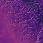
On July 20, 2017, the Moderate Resolution Imaging Spectroradiometer (MODIS) on NASA’s Terra satellite captured a natural-color image of the fire and smoke spreading across central California. Data for the second image was acquired by the Thermal Infrared Sensor (TIRS) on the Landsat 8 satellite and is overlaid on a digital elevation model of the area. TIRS observes in wavelengths of 10.9 micrometers and 12.0 micrometers, revealing the amount of heat (thermal energy) radiating from the fiery landscape near the start of the fire. Cooler areas are dark, while warmer areas are bright.
According to a report from CalFire issued at noon local time on July 21, the fire had destroyed 58 residences and 60 minor structures, while damaging 11 homes and another six minor structures. News outlets reported that evacuations were ordered for the town of Mariposa, a tourist gateway on the way to Yosemite; those orders were lifted by the afternoon of July 21. Yosemite does not appear to be at risk, as the fire has been moving south, away from the park.
CalFire reported that more than 3,800 people and 470 fire engines were fighting the blazes, which are in steep and rugged terrain that can be difficult to access. The weather has been hot and dry, and those conditions are expected to continue for a few more days. Though the region emerged from drought this winter, many trees were severely weakened or killed by the lack of water and the ravages of bark beetles.
The cause of the fire is under investigation. However, a fire-prevention campaign by the California Wildland Fire Coordinating Group notes that an estimated 95 percent of wildfires in California are sparked by humans.
References & Resources
- CalFire (2017, July 21) Detwiler Fire. Accessed July 21, 2017.
- ABC News (2017, July 21) California fire destroys 58 homes as crews race to save town. Accessed July 21, 2017.
- Los Angeles Times (2017, July 21) Massive California fire sends smoke all the way to Idaho while choking Yosemite and Lake Tahoe. Accessed July 21, 2017.
- San Jose Mercury News (2017, July 21) Town of Mariposa evacuated as Detwiler fire rages on. Accessed July 21, 2017.
NASA Earth Observatory images by Jesse Allen, using Terra MODIS data from the Land Atmosphere Near real-time Capability for EOS (LANCE), Landsat data from the U.S. Geological Survey, and ASTER Digital Elevation Model (GDM2) data from NASA/GSFC/METI/ERSDAC/JAROS, and U.S./Japan ASTER Science Team. Story by Mike Carlowicz.