Since mid-July 2017, something green has been coloring western Lake Erie. Scientists are familiar with the phenomenon, as the color stems from a large bloom of phytoplankton, which tend to thrive in parts of the lake during summer.
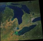
Warm water temperatures and nutrients from farm runoff can sustain phytoplankton blooms well beyond the summer. While leaves and crops on land took on typical fall colors of orange and brown, Lake Erie continues to display vivid shades of green. The Moderate Resolution Imaging Spectroradiometer (MODIS) on NASA’s Terra satellite captured this natural-color image of the region on September 24, 2017.
Satellite data (including this Terra image) contribute to analyses of bloom conditions, which are produced by the National Oceanic and Atmospheric Administration. According to the September 25 bulletin, this bloom contains microcystis, a type of freshwater cyanobacteria. These cyanobacteria can produce toxins that can contaminate drinking water, pose a risk to human and animal health (skin irritant, respiratory distress), and generally disturb coastlines.
The bloom was first reported in mid-July in Maumee Bay, just east of Toledo. By late September, it extended east into the central basin and north toward the coast of Ontario. At the time of this image, the highest densities were detected along the coast of Ontario and in Maumee and Sandusky bays.
“The image is a good representation of how a bloom moves through Lake Erie by this time of year,” said NOAA’s Jaclyn Ludema, who co-authors the bulletins. “Blooms form at the mouth of the Maumee River and commonly drift into the central basin. The outflow of the Detroit River pushes cyanobacteria concentrations away from the northwest corner of Lake Erie.”
Forecasts for the near-term suggest that winds will be too calm for surface waters to mix much. The lack of mixing allows for the formation of scums—areas where cyanobacteria clumps together into floating mats. These are the brightest green areas in the image.
To see the dense green layer from another perspective, check out these photographs captured from the air and ground.
References & Resources
- NOAA Great Lakes Environmental Research Laboratory (2017, September 25) Great Lakes Harmful Algal Blooms (HABs) and Hypoxia. Accessed September 25, 2017.
NASA Earth Observatory image by Joshua Stevens, using MODIS data from LANCE/EOSDIS Rapid Response . Story by Kathryn Hansen.