


After a powerful nor’easter dumped snow across a thousand miles of the U.S. East Coast, yet another blast of bitterly cold air spilled into the region and drove already low temperatures even lower.
Statisticians and meteorologists had plenty to tally as city after city broke daily low temperature records, but perhaps the most dramatic sign of the extreme cold emerged offshore. Many rivers, bays, and estuaries along the coast froze over, including some that only rarely have ice.
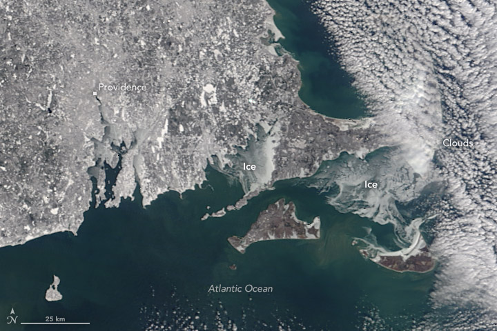
The Moderate Resolution Imaging Spectroradiometer (MODIS) on Terra captured this trio of images on January 7, 2018. The first shows ice in Delaware Bay—between New Jersey, Pennsylvania, and Delaware—and the northern part of the Chesapeake Bay in Maryland. The second shows ice in the Albemarle Sound in North Carolina. The third shows Rhode Island and southeastern Massachusetts, with ice in Buzzards Bay and Nantucket Sound.

The U.S. Coast Guard warned mariners of icy conditions and started operations to break up ice in some areas. Basins and waterways that are shallow and less salty, such as coastal rivers and estuaries, tend to freeze before deeper, saltier water. (While fresh water freezes at 32°F (0°C), seawater freezes at 28 °F.)
On January 7, 2018, several cities experienced record low temperatures, according to the National Weather Service. Temperatures dropped to -20 degrees Fahrenheit (-29 Celsius) in Burlington, Vermont; -11°F in Portland, Maine; -2°F in Boston, Massachusetts; -9°F in Hartford, Connecticut; 2°F in Wilmington, Delaware; 1°F in Baltimore, Maryland; and 4°F in Raleigh, North Carolina.
References & Resources
- Delaware Online (2018, January 3) Icy Delaware Bay halts Thursday trips for Cape May-Lewes Ferry. Accessed January 8, 2018.
- National Snow & Ice Data Center Sea ice formation. Accessed January 8, 2018.
- NOAA Can the Sea Freeze? Accessed January 8, 2018.
- The Baltimore Sun (2018, January 5) Amid region's cold snap, DNR deploys ice breakers in Annapolis and around Chesapeake waterways. Accessed January 8, 2018.
- The Boston Globe (2018, January 8) It’s a glacier out there: Waters off Mass. are freezing solid. Accessed January 8, 2018.
- The Boston Globe (2018, January 8) Stunning video shows frozen ocean in Falmouth. Accessed January 8, 2018.
- The Star-Ledger (2018, January 7) With the Delaware Bay frozen, people venture onto the ice in Cape May. Accessed January 8, 2018.
- U.S. Coast Guard (2018, January 4) Coast Guard sets seasonal ice condition 2 in northern Chesapeake Bay and tributaries. Accessed January 8, 2018.
NASA image by Jeff Schmaltz, LANCE/EOSDIS Rapid Response. Image cropping and caption by Adam Voiland.
None


