November 4, 2015
Eruption of Mount Rinjani, Indonesia
In late October 2015, a 3,726-meter (12,224-foot) volcano on the Indonesian island of Lombok began erupting. In the days that followed, ash from Mount Rinjani blanketed towns and farmland across three Indonesian islands and shut down air traffic to a number of airports.
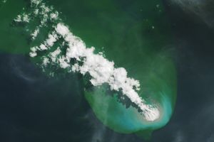
The Moderate Resolution Imaging Spectroradiometer (MODIS) on NASA’s Terra and Aqua satellites acquired these natural-color images of the plume. Ash drifted westward from Lombok toward Bali and Java. A small segment of eastern Java’s coast is visible to the southwest of Bali.
Terra MODIS captured the top image at 10:25 a.m. local time (02:25 Universal Time) on November 3. According to Indonesia’s National Disaster Management Authority (BNPB), the plume ascended 3.5 kilometers (11,500 feet) above sea level, or 1 kilometer (3,300 feet) above Barujari crater. Westward moving ash blanketed seven villages in North Lombok. By evening, Ngurah Rai International Airport in Bali had closed, stranding about 6,000 passengers.
Aqua MODIS captured the bottom image a day later at 2 p.m. local time (06:00 Universal Time) on November 4. BNPB reported that another eruption that morning had lofted ash to 4.3 kilometers (14,000 feet) above sea level. Winds now carried the plume toward the west and southwest. Turn on the image comparison tool to see the plume change in both magnitude and direction.
By November 4, airports had temporarily closed on all three islands, including Selaparang airport in Mataram. No evacuation measures were in place, but people were advised to stay beyond a 3-kilometer radius of the caldera.
Rinjani last erupted in 2009–2010.
- References & Resources
- The Guardian (2015, November 4) Indonesian volcano’s ash cloud strands holidaymakers–and Indian gangster. Accessed November 5, 2015.
- Indonesia’s National Disaster Management Authority (BNPB) (2015, November 4) Mount Rinjani Still Erupt, Ngurah Rai Keeps Closed. Accessed November 5, 2015.
- Indonesia’s National Disaster Management Authority (BNPB) (2015, November 3) Mount Rinjani Erupt, Ngurah Rai Airport Closed Temporarily. Accessed November 5, 2015.
- The Jakarta Post (2015, November 5) Volcanic ash threatens health, flights in Bali. Accessed November 5, 2015.
- The Jakarta Post (2015, November 4) Three airports closed following Mt. Rinjani eruption. Accessed November 5, 2015.
- Smithsonian Institution Global Volcanism Program (2015, November) Rinjani. Accessed November 5, 2015.
NASA images by Jeff Schmaltz, LANCE/EOSDIS Rapid Response. Caption by Kathryn Hansen.