![Request for Information – Potential [Placeholder for Prize]](https://assets.science.nasa.gov/dynamicimage/assets/science/psd/solar/2023/09/s/solarsystem_0.jpg?w=1024)


March 17, 2016
Northern California Floodway Fills
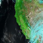
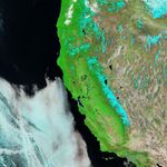
Storms in March 2016 brought some relief to drought-stricken northern California, as multiple days of rainfall partly replenished the area’s reservoirs. The water level of Lake Shasta, for example, returned to its historic average for mid-March.
The abundant rainfall also meant that flood protection systems were hard at work. The Shasta Dam spanning the Sacramento River is one point of flood control for the Sacramento Valley. Farther south along the rain-swollen river, water flowed into Yolo Bypass—a floodway between Davis and Sacramento—for the first time in three years.
The Moderate Resolution Imaging Spectroradiometer (MODIS) on NASA’s Terra satellite captured these images of the river and floodway. The top image was acquired on March 18, 2015, when the area was relatively dry. The second image was acquired on March 17, 2016, after water topped the Fremont Weir and spilled into the bypass. Turn on the image comparison tool to see the difference.
The images are false color, composed from a combination of infrared and visible light (MODIS bands 7-2-1). Water in the river and bypass is dark blue; snow is light blue; vegetation is green; and bare ground is brown.
In the second image, the water level at Fremont Weir measured about 10.7 meters (35 feet)—still more than five feet below flood stage. The water level in the top image was about 4 meters (13.5 feet).
Yolo Bypass covers about 60,000 acres of private and public land, which has been irregularly inundated with water since construction of the concrete, water-diverting system in the 1920s. It last filled with water in 2012.
References & Resources
- American Rivers (2014) Yolo Bypass and the Fremont Weir. Accessed March 18, 2016.
- California Nevada River Forecast Center (2016, March 18) Sacramento River–Fremont Weir. Accessed March 18, 2016.
- CBS Sacramento (2016, March 17) VIDEO: Yolo Bypass Flooded for First Time Since 2012. Accessed March 18, 2016.
- Los Angeles Times (2016, March 16) Northern California highway crumbles as storm-soaked hillside collapses. Accessed March 18, 2016.
- The Sacramento Bee (2016, March 12) Sacramento River flows over weir into Yolo Bypass. Accessed March 18, 2016.
NASA Earth Observatory images by Jesse Allen, using data from the Land Atmosphere Near real-time Capability for EOS (LANCE). Caption by Kathryn Hansen.