![Request for Information – Potential [Placeholder for Prize]](https://assets.science.nasa.gov/dynamicimage/assets/science/psd/solar/2023/09/s/solarsystem_0.jpg?w=1024)


The Asian monsoon dominates the climate of Southeast Asia. From roughly mid-April to September, it is rainy and hot; from November to mid-March, it is cooler and dry. Late in the dry season, fires become widespread (both intentional and accidental) throughout the Indochina peninsula as people use burning to clear and maintain agricultural and residential landscapes.
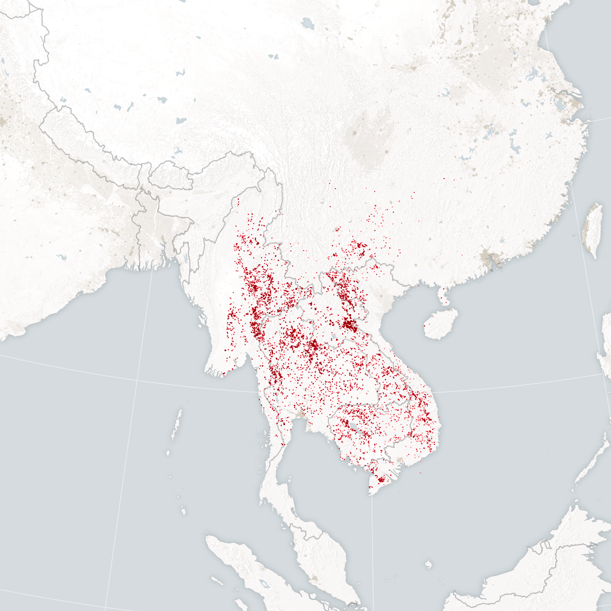
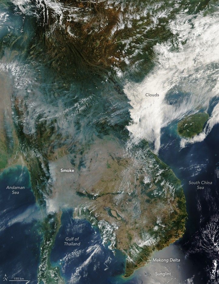
The Visible Infrared Imaging Radiometer Suite (VIIRS) sensor on the Suomi NPP satellite captured this natural-color image showing large numbers of small fires burning throughout the Indochina peninsula on March 19, 2016. Notice the thick cloud of smoke that obscures much of western Thailand and eastern Myanmar (Burma). The map below, based on the infrared observations collected by the VIIRS at the same time, shows the locations where VIIRS detected heat from the fires. Hot spots are shown with red.
Fire has a long history as a land management tool in Southeast Asia; most of the fires detected by the satellite were likely lit intentionally. In cultivated lowlands (tan area), farmers use fire to burn crop debris after harvest—often rice—and to prepare the land for the growing season. In the mountains (green), some people practice swidden agriculture, a farming system sometimes called “shifting agriculture” or “slash and burn” that involves clearing forested areas with fire, planting crops for a few years, and then letting brush and forest retake the fields during a fallow period intended to replenish soil nutrients. Fires are also sometimes lit to promote the growth of grasses used to make thatch roofs and brooms, to encourage the reproduction of certain mushrooms, to make seeds of some wild plant seeds germinate, and to flush out game during hunts for wildlife, according to a report from the United Nations Food and Agriculture Organization.
Though many of the fires were surely lit intentionally, natural conditions are potentially intensifying them and causing some to burn out of control. Southeast Asia is in the midst of a drought that has parched forests and other vegetation. Observers in Vietnam are calling the drought there the worst in 90 years. The lack of rain has led to intrusions of salt water into rice paddies and other croplands along the Mekong delta. In Thailand, authorities have diverted water from the Mekong River to agricultural areas in response to the dry weather, a move that has worried neighboring countries. In an attempt to ease tensions, China announced in March that it would release extra water into the Mekong at the Jinghong Hydropower Station.
Further Reading
- China Daily (2016, March 16) Mekong Delta faces worst drought, saltwater intrusion in century. Accessed March 24, 2016.
- The Diplomat (2016, March 16) Facing Mekong Drought, China to Release Water From Yunnan Dam. Accessed March 24, 2016.
- The Strait Times (2016, March 16) Drought-hit Thailand taps Mekong water. Accessed March 24, 2016.
References & Resources
- Food and Agriculture Organization Community involvement in fire management: cases and recommendations for community-based fire management in Thailand. Accessed March 24, 2016.
- NASA Earth Observatory (2010) Fires in Southeast Asia.
- Shi, Y. & Yamaguchi, Y. (2014, August 21) A high-resolution and multi-year emissions inventory for biomass burning in Southeast Asia during 2001–2010. Atmospheric Environment, 98, 8-16.
- The Asia Foundation (2014, March 26) Transboundary Pollution in Northern Thailand Causes Dangerous Levels of Smog. Accessed March 24, 2016.
NASA image (top) by Jeff Schmaltz, LANCE/EOSDIS Rapid Response . NASA Earth Observatory map (bottom) by Joshua Stevens. Caption by Adam Voiland.