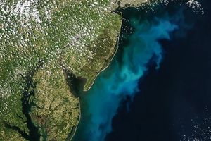
The estuarine and marine environments of the United States’ easternseaboard provide the setting for a variety of natural and humanactivities associated with the flow of water. This set of Multi-angleImaging SpectroRadiometer images from October 11, 2000 captures theintricate system of barrier islands, wetlands, andestuaries comprising the coastal environments of North Carolina andsouthern Virginia. On the right-hand side of the images, a thin line ofland provides a tenuous separation between the Albemarle and PamlicoSounds and the Atlantic Ocean. The wetland communities of this area arevital to productive fisheries and water quality.
The top image covers an area of about 350 kilometers x 260 kilometersand is a true-color view from MISR’s 46-degree backward-looking camera.Looking away from the Sun suppresses glint from the reflective watersurface and enables mapping the color of suspended sediments and plantlife near the coast. Out in the open sea, the dark blue waters indicatethe Gulf Stream. As it flows toward the northeast, this ocean currentpresses close to Cape Hatteras (the pointed cape in the lower portion ofthe images), and brings warm, nutrient-poor waters northward fromequatorial latitudes. North Carolina’s Outer Banks are often subjectedto powerful currents and storms which cause erosion along theeast-facing shorelines. In an effort to save the historic Cape Hatteraslighthouse from the encroaching sea, it was jacked out of the ground andmoved about 350 meters in 1999.
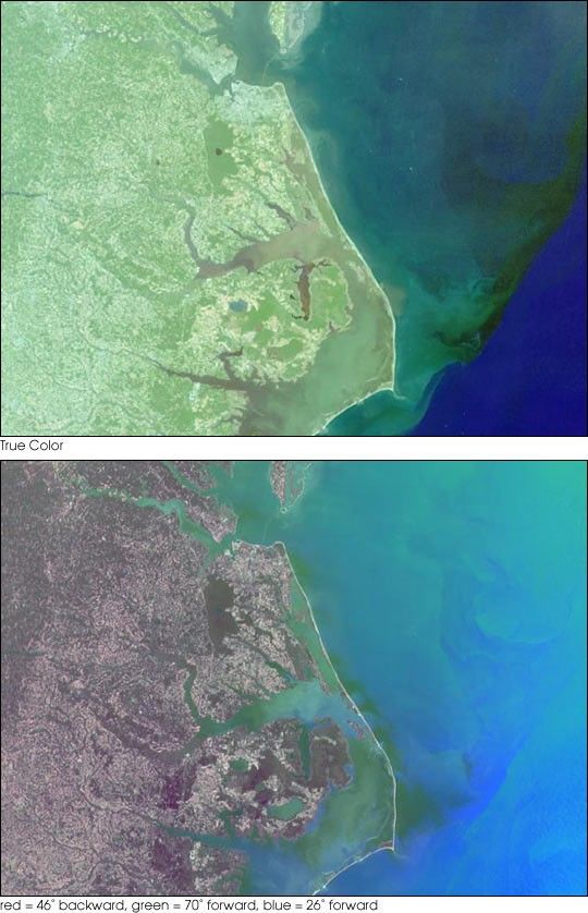
The bottom image was created with red band data from the 46-degreebackward, 70-degree forward, and 26-degree forward cameras displayed asred, green, and blue, respectively. The color variations in thismulti-angle composite indicate different angular (rather than spectral)signatures. Here, the increased reflection of land vegetation at theangle viewing away from the Sun causes a reddish tint. Water, on theother hand, appears predominantly in shades of blue and green due to thebright sunglint captured by the forward-viewing cameras. Contrastingangular signatures, most likely associated with variations in theorientation and slope of wind-driven surface waves, are apparent in thesunglint patterns.
Details of human activities are visible in these images. Near the topcenter, the Chesapeake Bay Bridge-Tunnel complex, which links Norfolkwith Virginia’s eastern shore, can be seen. The locations of two tunnelswhich route automobiles below the water appear as gaps in the visibleroadway. In the top image, the small white specks in the open waters ofthe Atlantic Ocean are ship wakes. The movements of the ships have beenvisualized by displaying the views from MISR’s four backward-viewingcameras in an animated sequence. These cameras successively observe thesame surface locations over a time interval of about 160 seconds. Thelarge version of the animation covers an area of 135 kilometers x 130kilometers. The land area on the left-hand side includes the birthplaceof aviation, Kitty Hawk, where the Wright Brothers made their firstsustained, powered flight in 1903.
References & Resources
Image courtesy NASA/GSFC/LaRC/JPL, MISR Team.