Enhanced Thematic Mapper Plus (ETM+)
The Enhanced Thematic Mapper Plus (ETM+) transformed Landsat into a global observatory, providing freely available data of the entire Earth for the first time. ETM+ spurred scientific breakthroughs in long-term, global land studies.
Overview
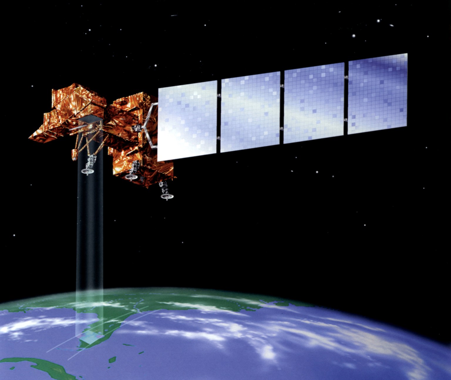
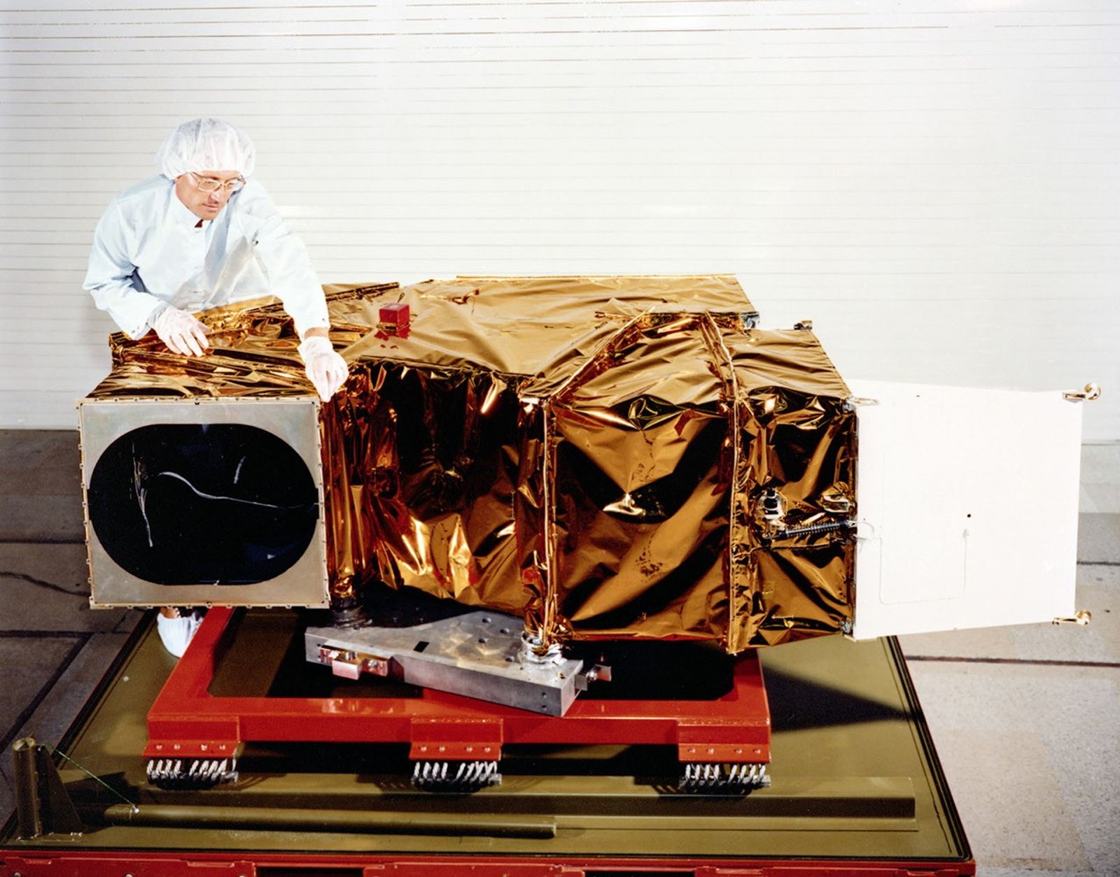
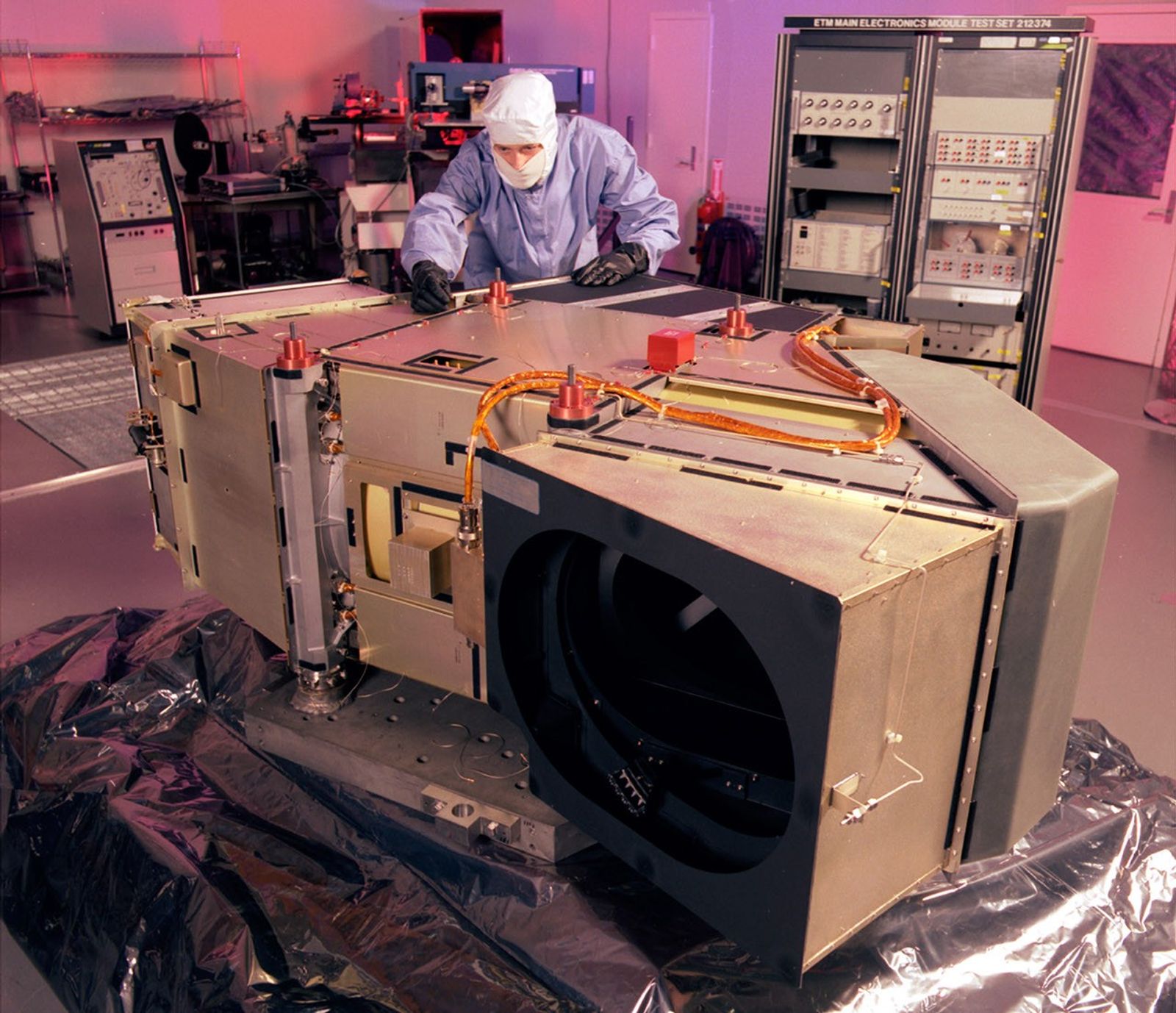
The Enhanced Thematic Mapper Plus (ETM+) was a multispectral scanning radiometer aboard Landsat 7. Its data enabled the first Landsat-based global assessments of Earth. Built by Raytheon Santa Barbara Remote Sensing (SBRS) on the legacy of earlier sensors, ETM+ collected data in eight 30-meter spectral bands in the visible, near-infrared, and short-wave infrared portions of the EM spectrum as well as a new 15-meter panchromatic band. It ensured continuity with previous sensors, allowing researchers to detect long-term change and decisionmakers to better manage resources.
Requirements
Landsat 7’s nominal science mission ran from April 1999 to April 2022. The ETM+ instrument was designed to meet the following requirements:
- Acquire, capture, and archive the equivalent of 250 scenes per day.
- Produce browse and metadata for all full and partial scenes acquired.
- Produce the equivalent of 100 Level 0 Reformatted (L0R) products and 100 Level 1 products per day, with phased expansion capabilities to handle an increased processing load.
- Accept data acquisition and product requests from users.
- Provide rapid turnaround of priority acquisitions and processing.
- Supply data to users at Cost of Fulfilling a User Request (COFUR).
- Note: In 2008, Landsat data became freely available to all users at no cost.
- Provide communications downlinks for data capture by fixed and transportable XBand ground stations using the Consultative Committee for Space Data Systems (CCSDS) standard protocol for communication of data.
Design
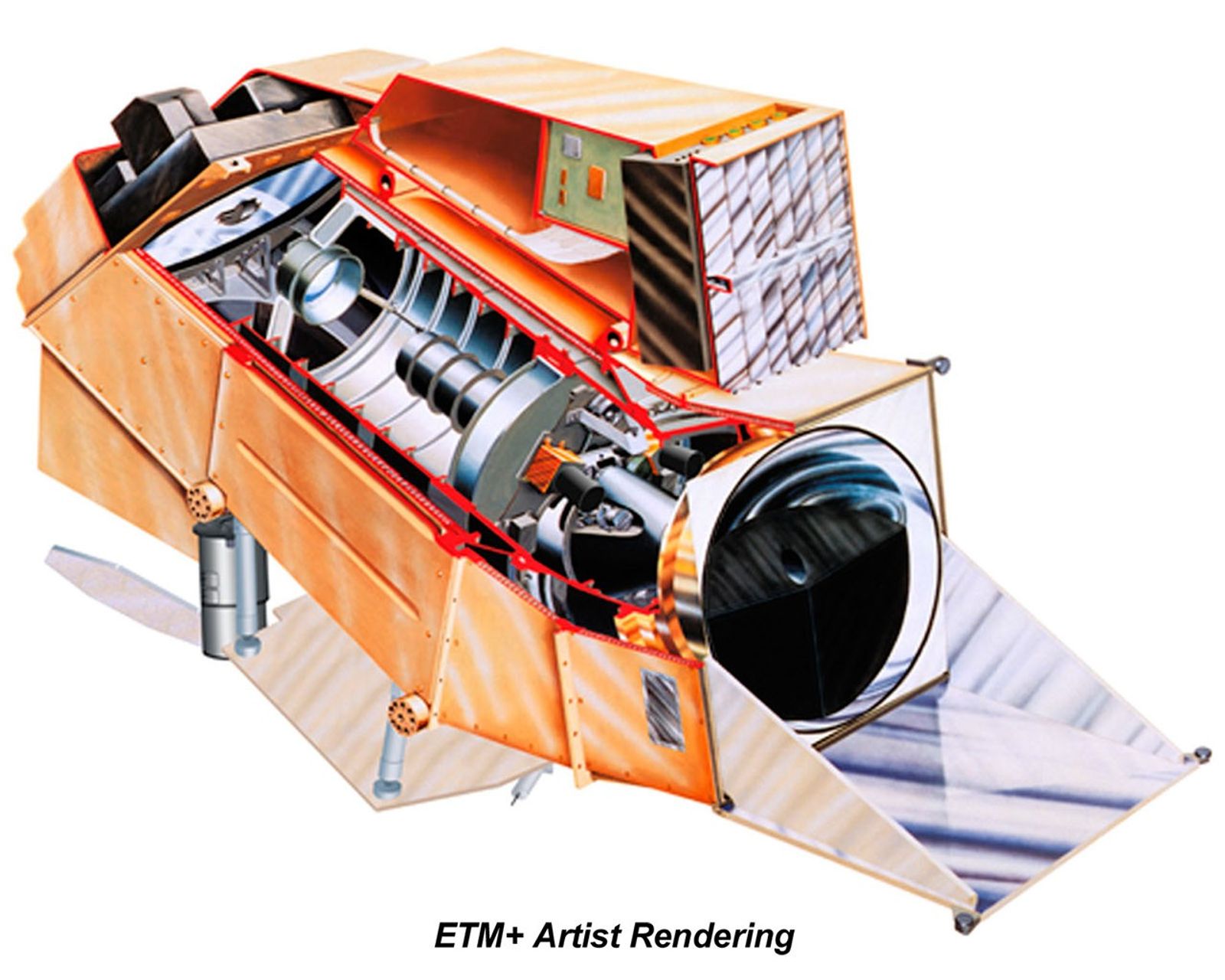
The Enhanced Thematic Mapper Plus (ETM+) was a “whisk-broom” instrument built on the design of the Thematic Mapper (TM) flown on Landsats 4 and 5. It used scan mirrors to sweep back and forth perpendicular to Landsat 7’s orbital path, building up a complete image strip-by-strip.
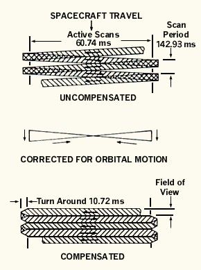
The instrument contained several key components. As the spacecraft moved forward along its track, the Scan Mirror Assembly (SMA) moved back and forth collecting solar energy, creating the 185-kilometer swath. Then, a telescope directed this energy to two focal planes which collected and filtered electromagnetic energy into eight spectral bands. ETM+ also contained a deep space radiator, relay optics, and the Scan Line Corrector (SLC). The SLC was a small mechanical device that compensated for the satellite’s motion during scanning, allowing the ETM+ instrument to scan smoothly from one strip to the next to create a complete, gap-free image.
Within each of the two focal planes, detectors measured the intensity of reflected light and emitted thermal energy. The detectors were arranged to separate solar energy into eight different bands.
ETM+ also had three independent on-board calibration systems to calibrate the panchromatic, visible and near-infrared (VNIR), and short-wavelength infrared (SWIR) bands. In addition to the calibration lamps and shutter used on the TM, the ETM+ added two new calibrators which allowed the instrument to use the sun as an absolute radiometric calibration source. These calibrators, along with ground-based validation, produced radiometric uncertainty within five percent—a significant improvement from previous sensors. This accuracy provided a reliable standard for integrating ETM+ data with other satellite observations.
Spectral Bands
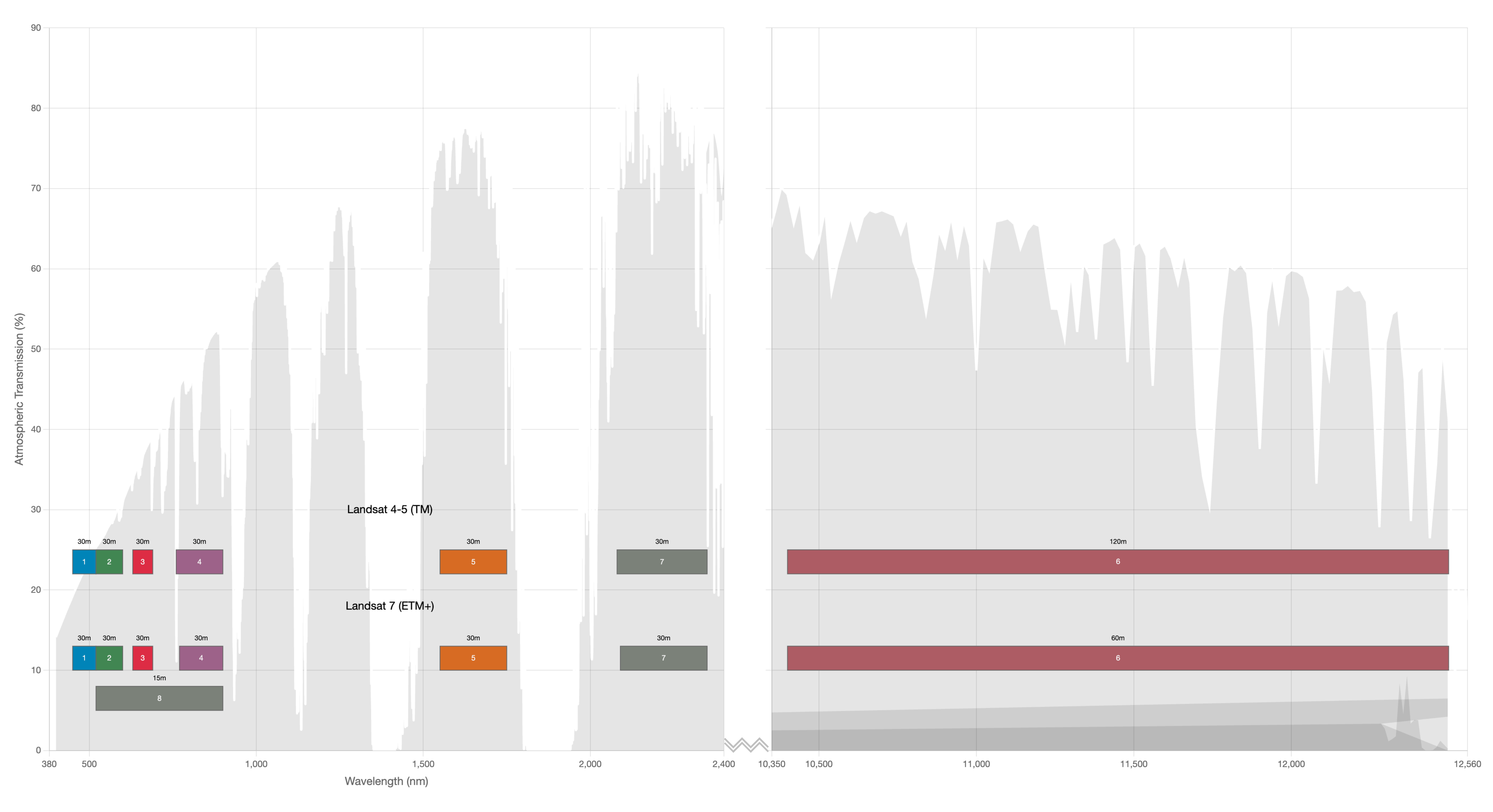
ETM+ captured data in eight spectral bands. Seven of these bands mirrored those collected by the Thematic Mapper (TM), covering visible, near-infrared, shortwave-infrared, and thermal-infrared wavelengths. A new 15-meter panchromatic band (band 8, 0.52-0.90 μm) provided higher spatial resolution. The reflective bands maintained a 30-meter spatial resolution, while the thermal band (band 6, 10.4-12.5 μm) had an improved 60-meter resolution (compared with 120 meters on the TM).
| Band | Band width (μm) | GSD (m) |
|---|---|---|
| 1 - Blue | 0.45-0.515 | 30 |
| 2 - Green | 0.525-0.605 | 30 |
| 3 - Red | 0.63-0.69 | 30 |
| 4 - Near-infrared (NIR) | 0.775-0.90 | 30 |
| 5 - Shortwave-infrared (SWIR) 1 | 1.55-1.75 | 30 |
| 6 - Thermal-infrared (TIR) | 10.4-12.5 | 60 (resampled to 30) |
| 7 - Shortwave-infrared (SWIR) 2 | 2.08-2.35 | 30 |
| 8 - Panchromatic | 0.52-0.90 | 15 |
Selected Publications
- Chander, G., Xiong, X., Choi, T.-Y., & Amit Angal. (2010). Monitoring on-orbit calibration stability of the Terra MODIS and Landsat 7 ETM+ sensors using pseudo-invariant test sites. Remote Sensing of Environment, 114(4), 925–939. https://doi.org/10.1016/j.rse.2009.12.003
- Goward, S. N., Masek, J. G., Williams, D. L., Irons, J. R., & Thompson, R. J. (2001). The Landsat 7 mission. Remote Sensing of Environment, 78(1-2), 3–12. https://doi.org/10.1016/s0034-4257(01)00262-0
- Kovalskyy, V., & Roy, D. P. (2013). The global availability of Landsat 5 TM and Landsat 7 ETM+ land surface observations and implications for global 30m Landsat data product generation. Remote Sensing of Environment, 130, 280–293. https://doi.org/10.1016/j.rse.2012.12.003
- Markham, B. L., Thome, K. J., Barsi, J. A., Kaita, E., Helder, D. L., Barker, J. L., & Scaramuzza, P. L. (2004). Landsat-7 ETM+ on-orbit reflective-band radiometric stability and absolute calibration. IEEE Transactions on Geoscience and Remote Sensing, 42(12), 2810–2820. https://doi.org/10.1109/tgrs.2004.836389
- Masek, J. G., Honzak, M., Goward, S. N., Liu, P., & Pak, E. (2001). Landsat-7 ETM+ as an observatory for land cover. Remote Sensing of Environment, 78(1-2), 118–130. https://doi.org/10.1016/s0034-4257(01)00254-1
- Roy, D. P., Ju, J., Kline, K., Scaramuzza, P. L., Kovalskyy, V., Hansen, M., Loveland, T. R., Vermote, E., & Zhang, C. (2010). Web-enabled Landsat Data (WELD): Landsat ETM+ composited mosaics of the conterminous United States. Remote Sensing of Environment, 114(1), 35–49. https://doi.org/10.1016/j.rse.2009.08.011
- Roy, D. P., Kovalskyy, V., Zhang, H. K., Vermote, E. F., Yan, L., Kumar, S. S., & Egorov, A. (2016). Characterization of Landsat-7 to Landsat-8 reflective wavelength and normalized difference vegetation index continuity. Remote Sensing of Environment, 185, 57–70. https://doi.org/10.1016/j.rse.2015.12.024
- Thome, K. J. (2001). Absolute radiometric calibration of Landsat 7 ETM+ using the reflectance-based method. Remote Sensing of Environment, 78(1-2), 27–38. https://doi.org/10.1016/s0034-4257(01)00247-4