






















NISAR Mission Overview

Quick Facts
Launched July 30, 2025 from the Satish Dhawan Space Centre in India
NISAR is providing new capabilities for measuring changes across Earth’s land and ice-covered regions every 12 days using advanced radar technology. The mission uses L-band and S-band synthetic aperture radar (SAR) to observe changes in land, water, vegetation, glaciers, and ice sheets. NISAR’s L-band observations provide global coverage, while S-band observations are acquired over India and selected areas around the world. Unlike optical sensors, SAR can collect observations regardless of cloud cover or sunlight conditions, enabling consistent monitoring of Earth’s surface day or night and through most weather conditions. NISAR observations provide critical information to improve our understanding of ecosystem dynamics, natural hazards, coastal changes, groundwater movement, and other processes that shape our planet. These observations support applications that help protect communities, improve disaster preparedness and response, manage natural resources, and advance scientific understanding of Earth’s dynamic systems.
NISAR will observe Earth’s land and ice-covered surfaces globally with 12-day regularity on ascending and descending passes, sampling Earth on average every 6 days for a baseline 3-year mission.
Mission Characteristics
| Characteristic | Description |
| Mission Partnership | Joint NASA–ISRO (Indian Space Research Organisation) Earth-observing mission |
| Launch Date | July 30, 2025 |
| Spacecraft Mass | 2.8 metric tons |
| Orbit Type | Sun-synchronous polar orbit |
| Orbit Altitude | 747 km |
| Orbit Inclination | 98.4° |
| Repeat Cycle | 12 days (exact repeat cycle) |
| Orbit Control | Maintained within 500 m of the reference orbit |
| Look Direction | Left-looking (south-looking) |
| Mission Duration | 3-year baseline science mission |
| Radar Instruments | Dual-frequency Synthetic Aperture Radar (SAR): L-band (24-cm wavelength) and S-band (9.4-cm wavelength) |
| Key Technology | SweepSAR —allows for wide swath and high spatial resolution simultaneously |
| Data Acquisitions | L-band: Global observations of land and ice-covered regions. S-band: Observations over India and selected calibration/validation (Cal/Val) sites around the world. |
| SAR Swath Width | 240 km |
| Spatial Resolution | 3–10 m, depending on acquisition mode |
| Polarization Capability | Single, dual, and quad polarization modes (acquisition-dependent) |
| L1 and L2 Data Products | Radiometrically calibrated and terrain-corrected amplitude products, focused complex SAR products, interferometric products including wrapped and unwrapped interferograms (for measuring displacement on the order of centimeters) and coherence layers, and pixel offset products for measuring large surface displacements (on the order of meters). |
| Derived Level 3 Product | Soil moisture product at 200-m spatial resolution over most areas and 400 m over the Sahara |
| Data Access | L-band products: available through the Alaska Satellite Facility (ASF) DAAC. S-band products and corresponding L-band observations from the same acquisitions: available through ISRO’s Bhoonidhi portal. |
| Data Policy | Free and open access |
Timeline
There are four phases of the NISAR mission, as shown in the graph below.
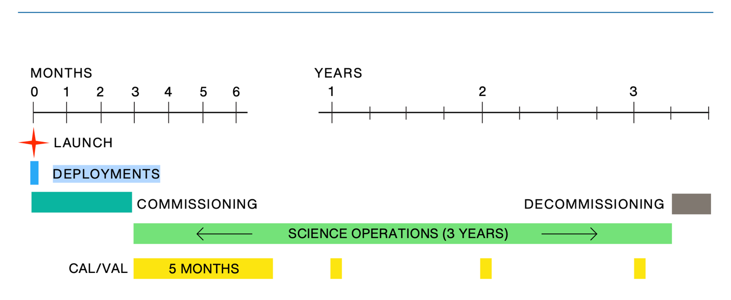
Each phase consists of:
- Launch Phase: NISAR was launched on July 30, 2025, from the Satish Dhawan Space Centre (SDSC), also known as the Sriharikota High Altitude Range (SHAR), located on the southeast coast of India. The mission was launched with the GSLV Mark II launch vehicle, provided by ISRO. The launch sequence spanned the period from liftoff, when the observatory was enclosed within the launch vehicle fairing, through spacecraft separation, and concluded with successful solar array deployment, establishment of an Earth-pointed attitude, and two-way communications with ground stations.
- Commissioning Phase: Following its launch on July 30, 2025, NISAR entered the commissioning phase. During this period, spacecraft systems were checked to ensure proper operation, and mission controllers established routine communication and control. Key milestones included deployment of the reflector boom and antenna, final orbit adjustments, and full instrument activation and checkout. Ground systems were also brought online to support routine data processing. During this phase, the first NISAR image was released to the public.
- Science Operations Phase: In early January 2026, NISAR entered the Science Operations Phase, which marks the start of routine, long-term collection of science data for research and applications. During this phase, the spacecraft maintains its science orbit through regular maneuvers that are scheduled to minimize impacts on science observations. The mission collects observations from the L-band and S-band instruments according to the observation plan developed through coordination between NASA and ISRO. Extensive calibration and validation (Cal/Val) activities were conducted during the first five months of science operations to assess instrument performance, validate science products, and improve processing algorithms. Annual Cal/Val campaigns continue throughout the remainder of the Science Operations Phase to monitor data quality and support algorithm improvements and reprocessing when needed. The Science Operations Phase includes three years of primary science operations designed to achieve NISAR’s Level 1 science objectives, which address changes in Earth’s solid surface, ecosystems, the cryosphere, and soil moisture. Following the baseline mission, extended operations may continue through mission activities supported by ISRO or through NASA’s Senior Review process.
- Decommissioning Phase: This 90-day phase is the final stage of the mission, during which the spacecraft is safely retired after completion of science operations. The spacecraft is placed into a disposal orbit and passivated to minimize the risk of creating hazards in the space environment.