


Enabling Capabilities
Enabling Earth System Science Research through maintenance, development and application of cross-divisional resources

Mission
Enabling Capabilities empowers the understanding of Earth’s interconnected systems through foundational technologies, processes, and workforce development.
Enabling Capabilities News
A NASA instrument designed to measure moonlight to help satellite sensors make more accurate measurements.
In fall 2025, more than 50 educators and over 1,500 young people across Maine and New Hampshire participated in NASA’s…
A group of elementary-aged students gather outside of Oldham County Public Library in La Grange, Kentucky, United States to look…
Magic is in the air. No wait… MAGEQ is in the air, featuring scientists from NASA centers across the country…

Seasonal snow plays a significant role in global water and energy cycles, and billions of people worldwide rely on snowmelt…

A cell phone, a computer—and your curiosity—is all you need to become a NASA citizen scientist and contribute to projects…
Overview
Enabling Capabilities are the foundational cross-cutting activities, opportunities, technologies, systems, or processes that enable specific objectives and functions to benefit all the Earth Science Division (ESD) program elements and Spheres (Atmosphere, Biosphere, Cryosphere, Geosphere, and Hydrosphere). The Enabling Capabilities’ cross functional team mission is to serve as a liaison across ESD facilitating the advancement of the understanding of the Earth system and the success of missions within the Division.
Funded Research Opportunities
Solicited program elements relevant to Enabling Capabilities are publicized through the Research Opportunities in Space and Earth Sciences (ROSES) NASA Research Announcements (NRAs) on the NASA Solicitation and Proposal Integrated Review and Evaluation System (NSPIRES) website. Past, open, and future solicitations can be searched and viewed on NSPIRES.
- A.4 Rapid Response and Novel Research in Earth Science: No due date
- F.5 Future Investigators in NASA Earth and Space Science and Technology: Due date TBD
Capability Areas
-
Airborne Science
The Airborne Science Program (ASP) provides access to platforms that can be used for in situ observation and remote sensing of the Earth’s atmosphere and surface. Aircraft have proven to be of significant value in Earth system science research testing new measurement approaches, collecting detailed data to better document and test Earth system process models, and providing satellite calibration/validation. They enable high-resolution temporal and spatial measurements of complex local processes, which are coupled to global satellite observations for a better understanding of the Earth system. The current fleet of NASA aircraft include the large science laboratory B777, the high-altitude ER-2 and WB-57, the P-3, and multiple business class Gulfstream aircraft. ASP also supports the use of commercial aircraft services to address airborne research requirements that are not economically efficient for NASA to own and operate. Finally, ASP provides skilled personnel and infrastructure required to plan and execute airborne campaigns.
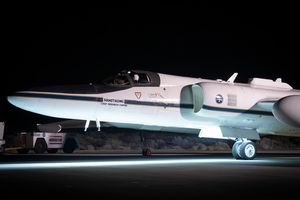
 The new NASA Boeing 777 arrives at the vendor for major structural modification. The first science flights for the new aircraft are expected in January 2027.NASA/Kirsten Boogaard
 -
Crowdsourcing
The Crowdsourcing effort engages the public in voluntary Earth system data collections, analyses, and interpretations to support NASA’s missions, accelerate scientific discovery, and enable societally relevant applications. Crowdsourcing participants are NASA’s eyes and ears on the ground, providing a cost-effective way to fill in spatial and temporal observation gaps that would otherwise be cost-prohibitive to accomplish. Participants include tourists, retirees, students, educators (formal and informal), library patrons, scientists, and more, united by their desire to make meaningful contributions to NASA, their communities, and the surrounding world. Crowdsourced Earth system observations support satellite validation efforts, contribute hyperlocal meteorological input to improve predictability, help assess satellite data product accuracy, enable timely community safety warning and response, provide surveillance for mosquito vector-borne diseases, and more.
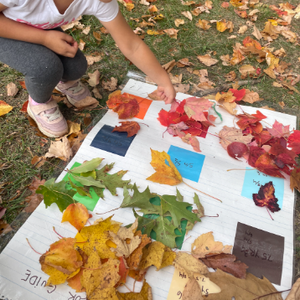
%20Collage.png?w=2434&h=1239&fit=clip&crop=faces%2Cfocalpoint) Crowdsource participants take measurements that support research endeavors and societally relevant applications across all parts of the Earth system.NASA/Amy P. Chen
Crowdsource participants take measurements that support research endeavors and societally relevant applications across all parts of the Earth system.NASA/Amy P. Chen -
Early Career Research
“Striving for Excellence in Earth Science”. The Early Career Research (ECR) Program’s vision is to empower the next generation of Earth science researchers to create a workforce that enables solutions to benefit society, respond to changes in the Earth’s system, and to support the Earth Science to Action Strategy. The ECR commitment is to support outstanding scientific research at all early career levels, ranging from high school to early career professionals, and enable greater participation across the Earth Science Division program elements and Spheres. ECR also works to cultivate global scientific leadership and provide sustainable support through a cohort experience that facilities workforce development and improves Earth Science retention efforts. ECR also serves as a liaison with other workforce development programs across NASA.
 ECR comprises four programs that include opportunities for all stages of early career participation, ranging from high school students to early career professionals. The programs include FIES2A, SARP, FINESST, and ECIP.NASA/Early Career Research Program
 -
Ground Networks and Calibration Labs
This effort ensures accurate measurements across NASA’s Earth Science Division through comprehensive pre- and post-launch activities. Pre-launch efforts focus on calibrating sensors and platforms in highly controlled laboratory environments, such as radiometric and geometric sensor characterization with traceable standards. Post-launch activities verify algorithm performance and validate geophysical data product accuracy across several temporal and spatial scales. The capability maintains active partnerships and conducts regular field campaign deployments in coordination with the Airborne Science activities.
The validation architecture employs a hierarchical measurement approach incorporating in situ/ground networks, balloon-borne vertical profiling systems, and complementary passive/active remotely sensed observations. These measurement capabilities, primarily funded through NASA programs and proven as core competencies at NASA centers or partnering organizations, enable cross-mission validation studies and support innovative Earth system science research across the agency's scientific and applications portfolio. The Goddard Laser for Absolute Measurement of Radiance (GLAMR) sphere illuminates three spectroradiometers with red light (~680 nm) for radiometric calibration. The light is generated by a custom laser system, which provides a spectrally and radiometrically uniform source.NASA/Julia Barsi
 -
Integrated Modeling Capabilities
The Integrated Modeling Virtual Institute (IMVI) coordinates synergistic Earth System model development across NASA’s modeling portfolio, along with strategic partnerships, to maintain and enhance NASA’s leading role in producing and providing advanced analyses, predictions, and projections of the Earth system. IMVI builds upon decades of NASA investments in Earth system modeling and data assimilation techniques, and aims to enhance cross-disciplinary synergies, consolidating core modeling tools and data products into an integrated and efficient portfolio that supports NASA’s Earth Science modeling and analysis strategy. IMVI development focuses on interdisciplinary system integration to deliver core products needed by NASA and society, enabled by NASA’s scientific computing infrastructure. The Scientific Computing project supports NASA's Earth Science Discovery supercomputing facility and funds IMVI initiatives including code modernization, data interfaces, and AI/ML applications for Earth observation, data assimilation into IMVI models, Earth system process emulation, and uncertainty characterization. In its initial phase, IMVI focuses on integrating core modeling activities and complementary strengths across the GEOS, Model-E, ISSM, LIS, and ECCO teams.
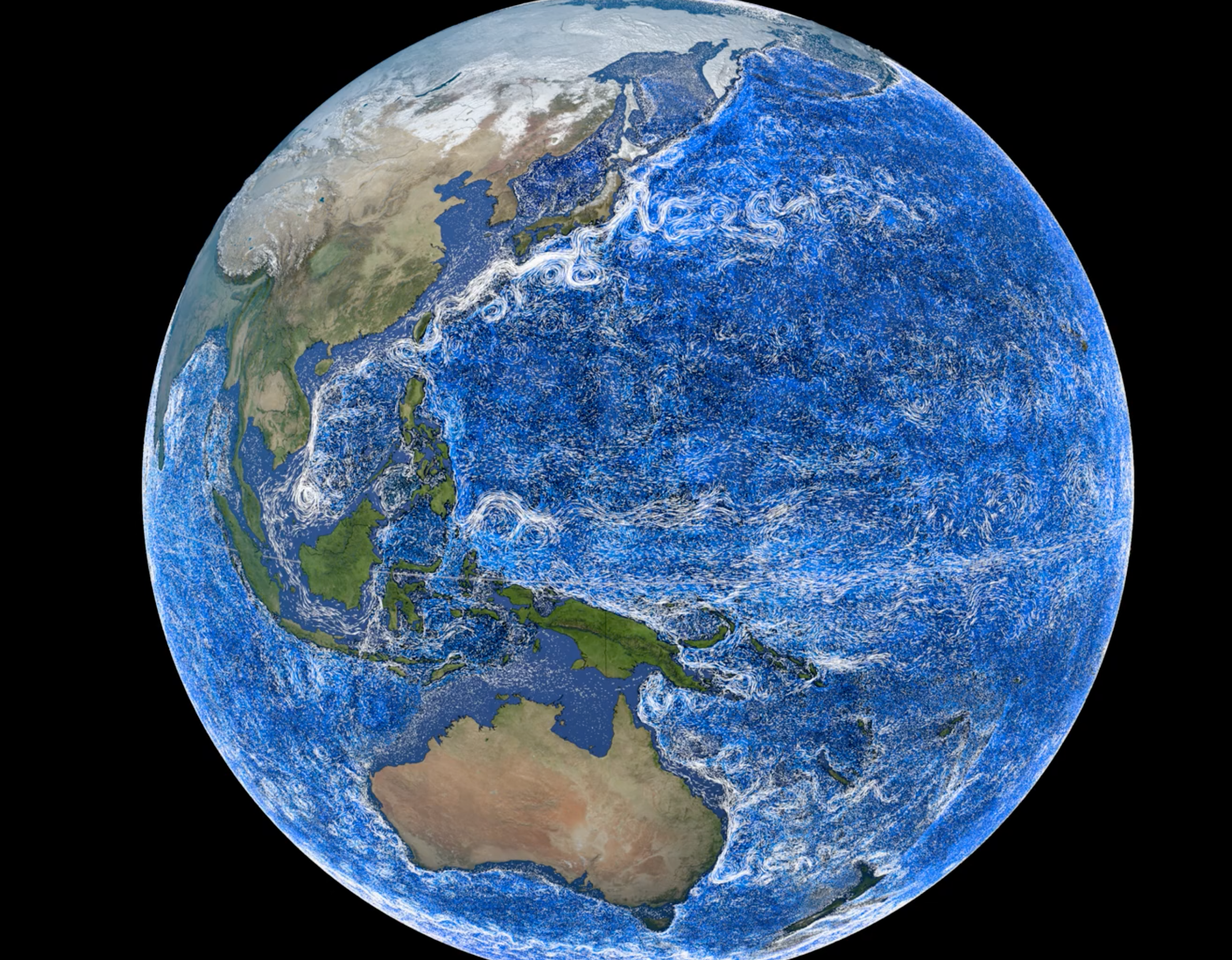 Western boundary currents stand out in white in this visualization built with Estimating the Circulation and Climate of the Ocean (ECCO) model data.NASA/Scientific Visualization Studio
 -
Space Geodesy Program
NASA's Space Geodesy Program (SGP) encompasses the development, deployment, operation, and maintenance of a global network of space geodetic observatories consisting of geodetic and associated instruments. In addition, SGP manages a data collection and transfer system, analysis, and the public dissemination of products required to maintain a stable terrestrial reference system, measure the Earth Orientation Parameters (EOP), and support NASA’s missions and the scientific community. The primary goals of the SGP are to contribute to the maintenance and improvement of a stable Terrestrial Reference Frame (TRF), EOP and precision orbit determination that meets the needs of NASA's Earth orbiting missions, geodynamics and broader Earth Science objectives, and NASA’s deep space navigation.
The NASA Earth Science Division funds the geodetic network operations and maintenance of three geodetic techniques: Satellite Laser Ranging (SLR), Very Long Baseline Interferometry (VLBI), and Global GPS Network (GGN). In addition, the program supports data processing and international collaboration for the International Terrestrial Reference Frame (ITRF). The SLR and VLBI efforts are managed by NASA Goddard Space Flight Center and GGN is managed by the Jet Propulsion Laboratory. A view of station position and velocity over North America determined using measurements by the Global Geodetic networks from multiple techniques.NASA/Scientific Visualization Studio
Missions and Campaigns
-
Missions
NASA Earth Science missions see Earth from space and enable researchers to monitor and understand our home planet. Missions range from instruments onboard the International Space Station (ISS) to Earth-orbiting satellites that span both large and small (i.e., CubeSats) form factors. NASA’s Earth Science missions often have US or other international partnerships and frequently collect data for 10 or more years.
-
Campaigns
Campaigns use instrumented aircrafts, balloons, ships, and surface networks over land and ocean, to better observe and understand our home planet. Campaigns represent coordinated efforts with intensive observation periods over one or more regions that can last anywhere from weeks to years. These measurements help support missions by providing initial tests of instruments before they are launched to space. Campaigns also provide important measurements to calibrate and validate satellite data in addition to collecting observations in support of related scientific endeavors.

Partnerships and Collaborating Projects
Airborne Science
Crowdsourcing
Early Career Research
Ground Networks and Calibration Labs
- Aerosol Robotic Network (AERONET)
- Advanced Global Atmospheric Gases Experiment (AGAGE)
- Micro-Pulse Lidar Network (MPLNET)
- Network for the Detection of Atmospheric Composition Change (NDACC)
- Pandonia Global Network (PGN)
- Southern Hemisphere Additional Ozonesondes (SHADOZ)
- Southern Ocean Carbon and Climate Observations and Modeling (SOCCOM)
- Total Carbon Column Observing Network (TCCON)
- Tropospheric Ozone Lidar Network (TOLNet)
- Wallops Precipitation and Ground Validation Data Archive
Integrated Modeling Capabilities
- Estimating the Circulation and Climate of the Ocean (ECCO)
- Global Modeling and Assimilation Office (GMAO)
- Goddard Institute for Space Studies (GISS)
- Ice Sheet and Sea Level System Model (ISSM)
- Land Information System
Space Geodesy
Contacts
Amy P. Chen
Ground Networks, Calibration Labs, and Crowdsourcing Program Scientist
Contact | Bio
Argyro Kavvada
Integrated Earth System Modeling Program Manager
Integrated Modeling Virtual Institute Program Manager
Contact | Bio
Craig R. Ferguson
Hydrosphere and Enabling Capabilities Program Manager (dual role)
Terrestrial Hydrology Research and Integrated Earth System Modeling Program Scientist (Scientific Computing Manager)
Contact | Bio
Cynthia Hall
Associate Program Scientist (ASRC Contractor)
Early Career Research Program
Contact
David Considine
Integrated Earth System Modeling Research
Contact | Bio
Derek Rutovic
Airborne Science Program Executive
Contact | Bio
Gerald Bawden
Special Projects
Contact | Bio
Wenying Su
Ground Networks, Calibration Labs, and Crowdsourcing Program Scientist (LaRC Detailee)
Contact | Bio
John T. Sullivan
Atmosphere and Enabling Capabilities Program Manager (dual role)
Ground Networks, Calibration Labs, and Crowdsourcing, Multi-Source Integrated Observatory Deputy Program Manager
Contact | Bio
Lucia Tsaoussi
Space Geodesy Research
Contact
Ryan Pavlick
Biosphere and Enabling Capabilities Program Manager (dual role)
Terrestrial Ecology Research and Airborne Science Program Scientist
Contact
Yaítza Luna-Cruz
Early Career Research Program Manager
Contact | Bio