


Full size color image (752 KB)
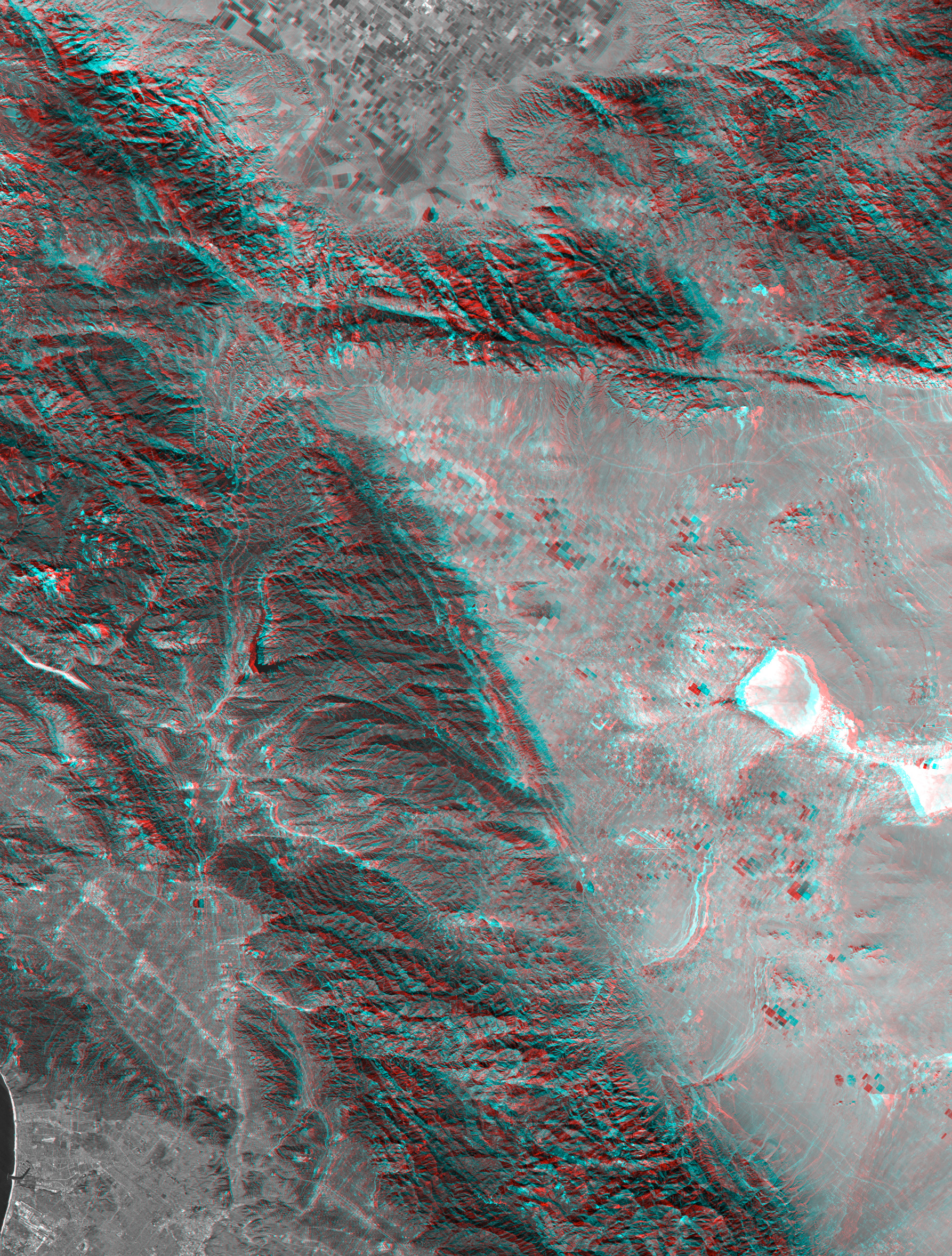
Full size anaglyph (3.1 MB)
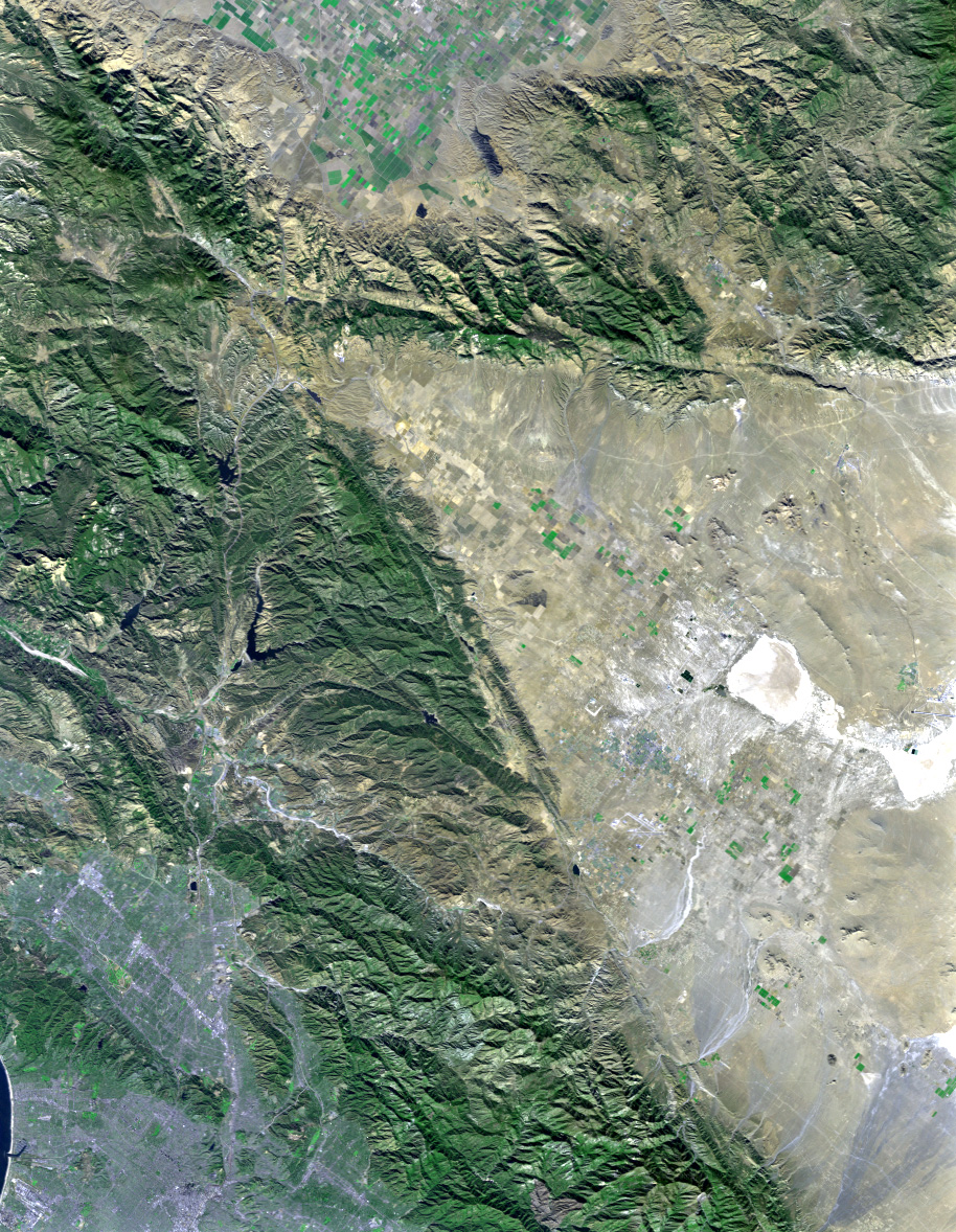
California’s topography poses challenges for roadbuilders. Northwest of Los Angeles, deformation of Earth’s crust along thePacific-North American crustal plate boundary has made transportationdifficult. Direct connection between metropolitan Los Angeles (image lowerleft) and California’s Central Valley (image top center) through the ruggedterrain seen on the left side of this image was long avoided in favor of longerbut easier paths. However, over the last century, three generations of roadshave traversed this terrain. The first was “The Ridge Route”, a two-lane road,built in 1915, which followed long winding ridge lines that included 697curves. The second, built in 1933, was to become four-lane U.S. Highway 99. Itgenerally followed widened canyon bottoms. The third is the current eight laneInterstate 5 freeway, built in the 1960s, which is generally notched intohillsides, but also includes a stretch of several miles where the twodirections of travel are widely separated and driving is “on the left”, ararity in the United States. Such an unusual highway configuration wasnecessary in order to optimize the road grades for uphill and downhill trafficin this topographically challenging setting.
This anaglyph was generated by first draping a Landsat satellite image over apreliminary topographic map from the Shuttle Radar Topography Mission (SRTM), thengenerating two differing perspectives, one for each eye. When viewed throughspecial glasses, the result is a vertically exaggerated view of the Earth’ssurface in its full three dimensions. Anaglyph glasses cover the left eye witha red filter and cover the right eye with a blue filter. Landsat has beenproviding visible and infrared views of the Earth since 1972. SRTM elevationdata matches the 30 meter resolution of most Landsat images and willsubstantially help in analyses of the large and growing Landsat image archive.
The elevation data used in this image was acquired by the Shuttle RadarTopography Mission (SRTM) aboard the Space Shuttle Endeavour, launched onFebruary 11, 2000. SRTM used the same radar instrument that comprised theSpaceborne Imaging Radar-C/X-Band Synthetic Aperture Radar (SIR-C/X-SAR) thatflew twice on the Space Shuttle Endeavour in 1994. SRTM was designed to collectthree-dimensional measurements of the Earth’s surface. To collect the 3-D data,engineers added a 60-meter-long (200-foot) mast, installed additional C-bandand X-band antennas, and improved tracking and navigation devices. The missionis a cooperative project between the National Aeronautics and SpaceAdministration (NASA), the National Imagery and Mapping Agency (NIMA) of theU.S. Department of Defense (DoD), and the German and Italian space agencies. Itis managed by NASA’s Jet Propulsion Laboratory, Pasadena, CA, for NASA’s EarthScience Enterprise, Washington, DC.
Size (of full images): 141 by 107 kilometers (88 by 66 miles)
Location: 34.5 deg. North lat., 118.7 deg. West lon.
Orientation: North toward upper right
Image: Landsat bands 1, 2&4, 3 as blue, green, and red, respectively
Date Acquired: February 16, 2000 (SRTM), November 11, 1986 (Landsat)
References & Resources
Image courtesy NASA/JPL/NIMA
None


