
Scientists representing the new-generation Earth Observing instrumentsaboard NASA’s Terra satellite gathered at the space agency’sWallops Island facility to study the atmosphere from multipleperspectives simultaneously.ÿ The intensive field campaign, called CLAMS(Chesapeake Lighthouse and Aircraft Measurements for Satellites), is akey step in the effort to better understand, and ultimately to predict,changes in Earth’s climate. CLAMS aimed at measuring pollution andother particles in a volume of air over ocean, and at the same timecharacterizing the way the dark water surface below reflects sunlightback toward space. The experiments continued through most of July andearly August 2001.
Data were collected at the Chesapeake Lighthouse, a platform in theAtlantic Ocean 25 kilometers off the Virginia coast, and by sixinstrumented aircraft, including NASA’s high-altitude ER-2 aircraftand the University of Washington’s Convair-580. At the sametime, the Multi-angle Imaging SpectroRadiometer (MISR), the MODerateresolution Imaging Spectroradiometer (MODIS), and the Clouds and theEarth’s Radiant Energy System (CERES) instruments on Terra observedthe scene from space.
The satellite instruments have been producing frequent, global,remote-sensing observations of Earth with unprecedented detail sinceearly 2000. The highly coordinated aircraft and lighthouse measurementsmade during CLAMS provide “ground truth,” allowing the satellitescientists to critically examine and improve their interpretation of theglobal data.
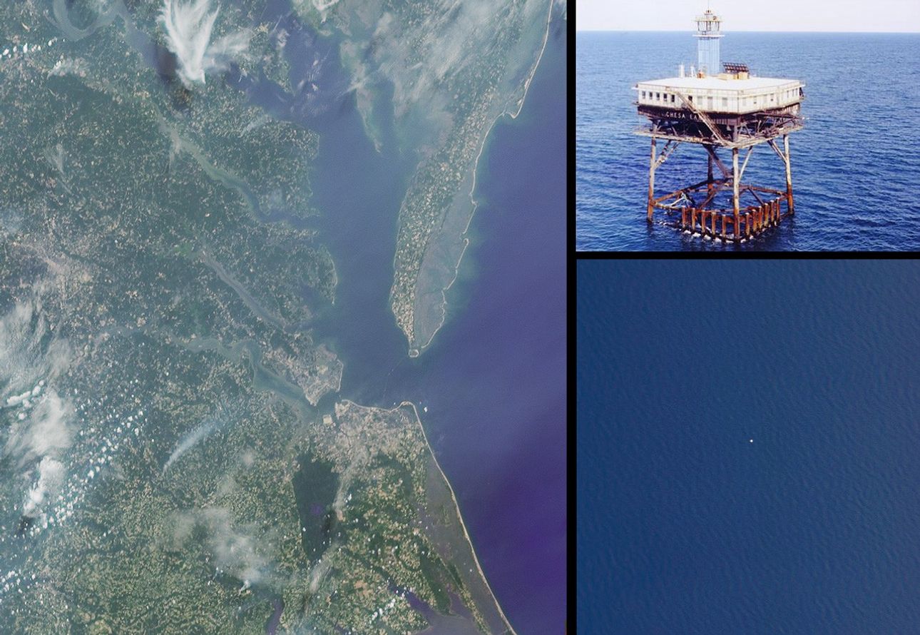
The left image in this montage is a true-color rendition of theChesapeake region as seen by the 60-degree backward-viewing MISR camera,near local noon on July 17, 2001 (Terra orbit 8407). The above-waterportions of the Chesapeake Bay Bridge-Tunnel, which connects CapeCharles and Norfolk, Virginia, are faintly visible to the right of imagecenter. The Chesapeake Lighthouse is located in the Atlantic Ocean, dueeast of Cape Henry at the southern end of Chesapeake Bay, though it isnot visible at the MISR resolution. The lower right image is adownward-looking (nadir) view of a 4-kilometer wide patch of oceanobtained near local noon on July 17 by the AirMISR instrument (anaircraft version of the satellite MISR) that flies at an altitude of 20kilometers aboard the ER-2. The spatial resolution of the AirMISR imageis about 35 times finer than that of the simultaneous MISR view; thesea-surface texture is faintly visible across the AirMISR scene, and theChesapeake Lighthouse itself shows up as a small white patch near thecenter of the image. The upper right image was taken from a helicopter,as it approached the Lighthouse from the north side.
For more about CLAMS, look here
References & Resources
Image courtesy NASA/GSFC/LaRC/JPL, MISR and AirMISR Teams.