


October 14-21, 2024
A Deluge for Roswell
Fall and summer tend to be the rainiest seasons in New Mexico, but the deluge that fell on parts of the state in late October 2024 stands out for its intensity.
According to the Albuquerque office of the National Weather Service, the Roswell airport received 5.78 inches (147 millimeters) of rain on October 19, an all-time daily record. That’s more than four times the average October rainfall for the region and half of its average annual rainfall. Other areas surrounding Roswell received as much as 9 inches (229 millimeters) in a matter of hours, according to the National Weather Service.
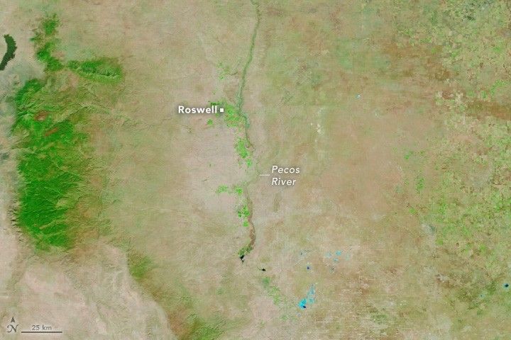
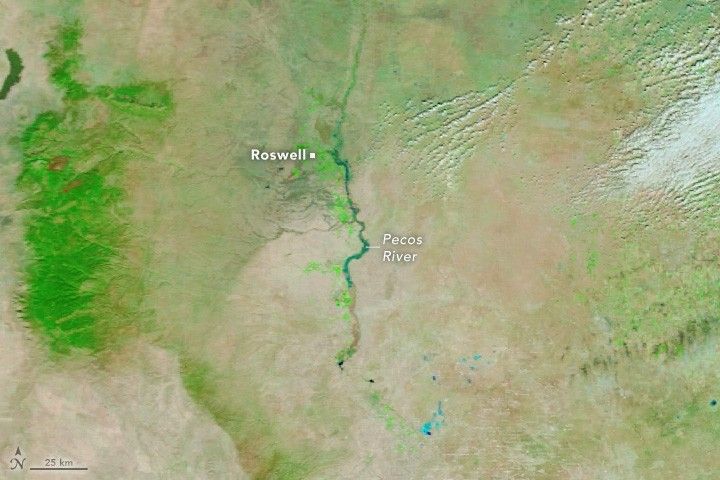
Much of the flooding in Roswell spilled from the Spring River, which runs through the city. By the time clouds had cleared enough for NASA’s Terra satellite to capture this image (right) on October 21, much of that water had receded. However, floodwaters were still visible along the Pecos River, to the east of Roswell. Terra acquired the other image (left) on October 14, before the extreme rainfall. Both images were captured by the MODIS (Moderate Resolution Imaging Spectroradiometer) sensor.
The false-color images were composed from a combination of infrared and visible light (MODIS bands 7-2-1), to make it easier to distinguish the water. Floodwater appears dark blue; saturated soil is light blue; vegetation is bright green; and bare ground is brown.
The unusual amount of rain was produced by an upper-level cut-off low that stalled over Arizona and funneled large amounts of moisture to New Mexico from the Gulf of Mexico, according to meteorologist Jeff Berardelli. The flash floods that ensued caused widespread damage to the town of 48,000 people. Floodwaters inundated roads, swept away and submerged cars, and damaged bridges and buildings. Authorities rescued 290 people, according to a statement from the New Mexico National Guard.
National Weather Service forecasts indicate that storms could bring another round of flash flooding to Roswell in the coming days. Flood monitoring resources and tools powered by NASA satellite data include the Flood Dashboard from the NASA Disasters Program, the Global Flood Monitoring System from the University of Maryland, a data pathfinder from the Earth Science Data Systems Program, and flooding monitoring and modeling training from the Applied Remote Sensing Training Program.
References & Resources
- Associated Press (2024, October 21) New Mexico authorities rescue hundreds after flooding strands many in high water and leaves 2 dead. Accessed October 22, 2024.
- Berardelli, J., via X (2024, October 21) I’ve seen tons of video on Roswell’s flooding but little explanation. Accessed October 22, 2024.
- City of Roswell, via Facebook (2024, October 20) Rescue efforts have been taking place throughout the night. Accessed October 22, 2024.
- El Paso Times (2024, October 20) Roswell flooding turns deadly as record-rainfall soaks New Mexico town. Accessed October 22, 2024.
- NASA Applied Remote Sensing Training (2022, September 21) ARSET - Monitoring and Modeling Floods using Earth Observations. Accessed October 22, 2024.
- NASA Earthdata (2024) Floods Data Pathfinder. Accessed October 22, 2024.
- National Weather Service Albuquerque (2024) Roswell has set a new all-time daily record rainfall of 5.78. Accessed October 22, 2024.
- New Mexico Office of the Governor (2024, October 21) Governor declares emergency in response to Roswell flooding. Accessed October 22, 2024.
NASA Earth Observatory images by Wanmei Liang , using MODIS data from NASA EOSDIS LANCE and GIBS/Worldview . Story by Adam Voiland .


