


For the second time in two weeks, a powerful tropical cyclone struck Madagascar. On January 31, Fytia battered the remote northwestern coast of the island with destructive winds and torrential rains that displaced thousands of people. Less than two weeks later, Gezani made a direct hit on one of the island's largest cities before sweeping past areas that Fytia had just flooded.
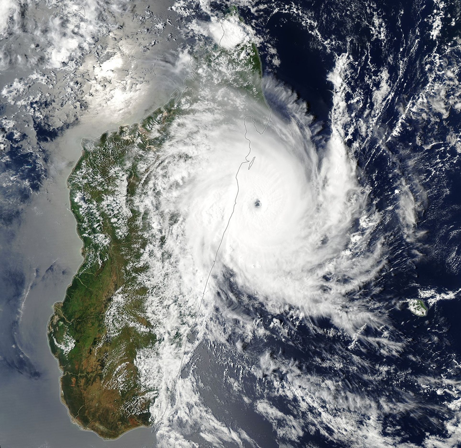
The MODIS (Moderate Resolution Imaging Spectroradiometer) on NASA’s Aqua satellite captured this image of Gezani as it neared Madagascar on February 10, 2026. At the time, the storm was undergoing rapid intensification. Its sustained winds peaked at 200 kilometers (125 miles) per hour before making landfall at Category 3 hurricane strength.
According to meteorologists with the Joint Typhoon Warning Center, the storm developed amid conditions "highly favorable" to strengthening, including sea surface temperatures above 28 degrees Celsius (82 degrees Fahrenheit), wind shear below 20 kilometers (12 miles) per hour, and an unusually moist atmosphere. As the storm passed near Toamasina, Madagascar's second-largest city, satellites that contribute to NASA's IMERG (Integrated Multi-satellite Retrievals for GPM) product measured rain rates up to 4 centimeters (1.6 inches) per hour.
The deluge caused widespread flooding in Toamasina and several other parts of the island. Preliminary damage assessments from Madagascar's National Office for Risk and Disaster Management linked the storm to dozens of deaths, hundreds of injuries, and damage to more than 27,000 homes. Reports from news outlets and humanitarian groups described chaotic conditions in Toamasina, with widespread power outages, numerous collapsed roofs, and a lack of clean water.
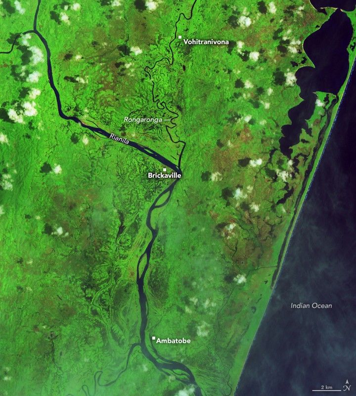
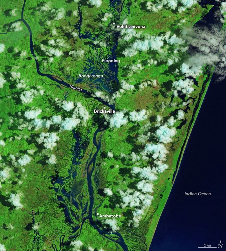


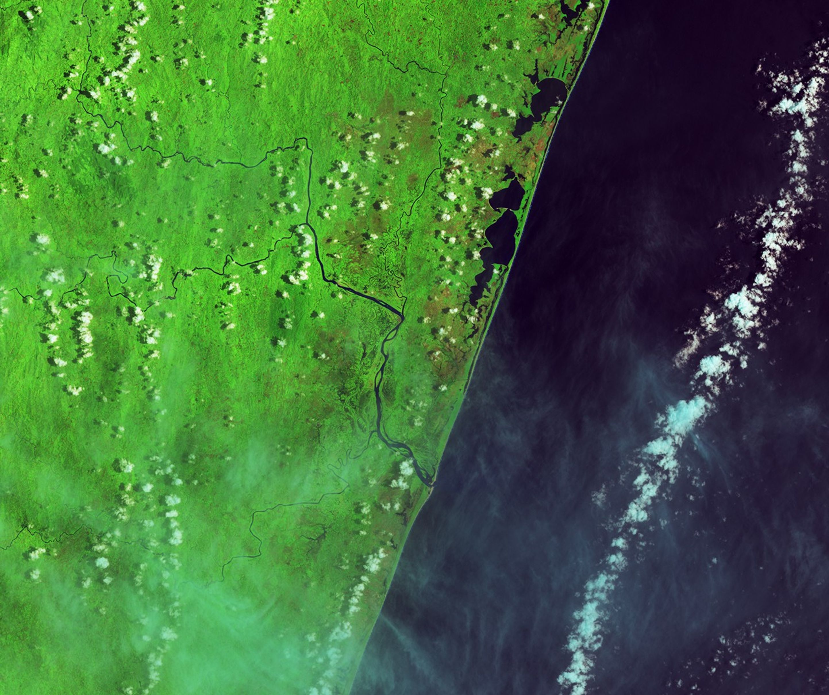
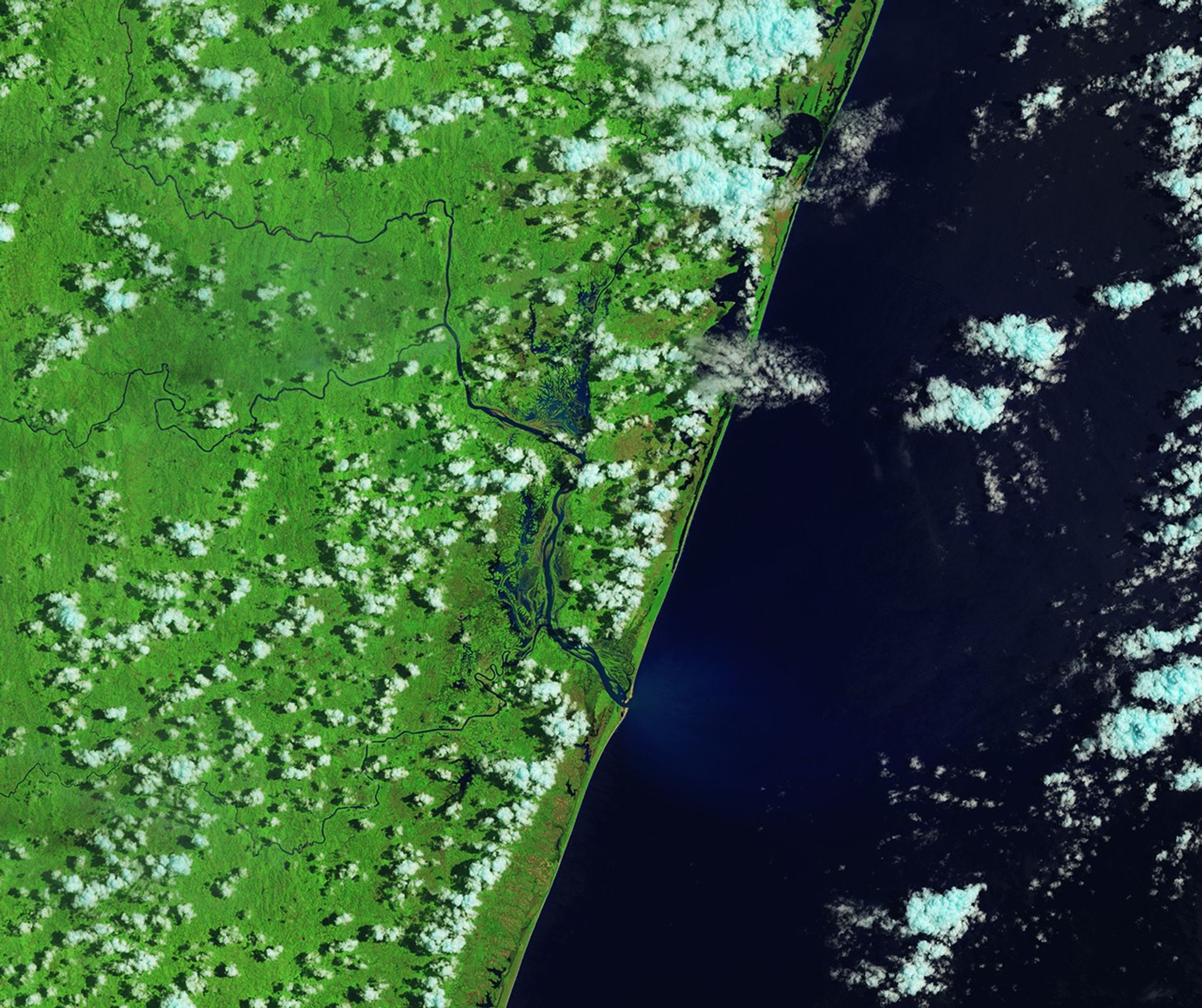
Before and After
January 29, 2026 – February 14, 2026
The OLI (Operational Land Imager) on Landsat 8 captured this false-color image of severe flooding near Brickaville, just south of Toamasina, on February 14, 2026 (right). For comparison, the left image shows the same area before the storm. Villages and farmland along the Rongaronga River appear particularly hard hit. Crops commonly grown in this area include rice, vanilla, lychees, black pepper, cloves, and cinnamon, according to researchers from the French Agricultural Research Centre for International Development.
Madagascar is one of the most cyclone-prone countries in Africa, with about six storms typically affecting the island each year and two making direct landfall. The cyclone season generally runs from November through April, with peak activity between January and March.
NASA Earth Observatory image by Lauren Dauphin, using MODIS data from NASA EOSDIS LANCE and GIBS/Worldview and Landsat data from the U.S. Geological Survey. Story by Adam Voiland.
References & Resources
- ACAPS (2024) Cyclone exposure and vulnerabilities. Accessed February 17, 2026.
- Associated Press (2026, February 12) Cyclone Gezani destroys 18,000 homes and causes at least 36 deaths in Madagascar. Accessed February 17, 2026.
- BNGRC (2026, February 16) Cyclone Gezani: Preliminary Assessment of Recorded Damage. Accessed February 17, 2026.
- BNGRC, via Facebook (2026) Posts. Accessed February 17, 2026.
- CIMSS Satellite Blog (2026, February 10) Cyclone Gezani makes landfall on Madagascar as a Category 3 storm. Accessed February 17, 2026.
- France24 (2026, February 11) Cyclone Gezani ravages Madagascar, leaving dozens dead and much of second city in ruins. Accessed February 17, 2026.
- Global Disaster Awareness and Coordination System (2026, February 17) Overall Red alert Tropical Cyclone for GEZANI-26. Accessed February 17, 2026.
- NASA Earthdata Tropical Cyclones. Accessed February 17, 2026.
- The Washington Post (2026, February 11) Death toll rises to 31 after Tropical Cyclone Gezani hits Madagascar and crushes houses. Accessed February 17, 2026.
- World Meteorological Organization (2026, February 13) Tropical cyclone Gezani hits Madagascar and threatens Mozambique. Accessed February 17, 2026.
- Yahoo News (2026, February 13) Madagascar cyclone death toll rises to 40, water, power still out. Accessed February 17, 2026.


