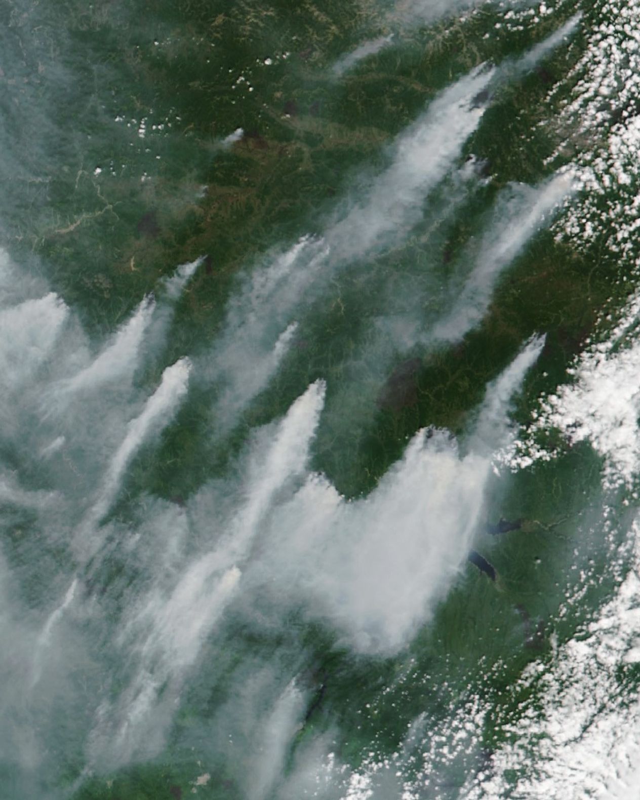


Large numbers of intense, smoky fires spread across eastern Russia in the summer of 2024, shrouding the region’s skies, forests, and communities in smoke. One of the most active areas has been the Amur oblast, which borders China’s Heilongjiang province.
The VIIRS (Visible Infrared Imaging Radiometer Suite) on the NOAA-NASA Suomi NPP satellite captured this image of smoke streaming from fires raging around Amur’s Zeya Reservoir on July 9, 2024.
While taiga dominates much of the sparsely populated area around the reservoir, forests thick with larch, spruce, and fir surround several towns, including Zolotaya, Zeya, Tutaul, Tynda, Ogoron, Kirovsky, Chasovnya, and Beregovoy. Placer gold mining is common in this area, particularly along streams and rivers west of the reservoir. Though most signs of mining are obscured by smoke, sand deposits and ponds associated with mining are visible as small tan areas in the upper left of the image.
On July 10, 2024, Russia’s Federal Forestry Agency reported that 44 fires were actively burning across 23,000 hectares (90 square miles) in the Amur oblast. Amur is one of eight areas in Russia that have declared a state of emergency due to fires. Other areas with large numbers of fires include Zabaikalsky Krai and the Republic of Sakha, the agency reported.
Satellites began to detect large fires burning in Amur in mid-May. New groups of fires flared up in June and July and spread rapidly as winds picked up and temperatures warmed.
Carbon emissions from Amur’s fires have been higher so far this year than during most other years over the past few decades, according to data shared by Mark Parrington, an atmospheric scientist with the European Centre for Medium-Range Weather Forecasts (ECMWF). Parrington tracks fires for the Copernicus Atmosphere Monitoring Service (CAMS) using a satellite-based data record that began in 2003.
In early July, he reported that carbon emissions from wildfires in the Amur oblast were nearing 10 megatons, higher than any year since 2003 except for 2015. CAMS estimates near-real-time wildfire emissions using its Global Fire Assimilation System (GFAS), which aggregates observations of fires made by the MODIS sensors on NASA’s Aqua and Terra satellites.
References & Resources
- Egidarev, E. & Simonov, E. (2015) Assessment of the environmental effect of placer gold mining in the Amur river basin. Water Resources, 42(7), 897-908.
- Federal Forestry Agency (2024, July 10) Forest fire situation in Russia as of 10.07.2024. Accessed July 10, 2024.
- Library of Congress (2009) Russia—administrative divisions. Accessed July 10, 2024.
- NASA ARSET (2021) Satellite Observations and Tools for Fire Risk, Detection, and Analysis. Accessed July 10, 2024.
- NASA Earthdata (2022) Wildfires. Accessed July 10, 2024.
- Parrington, M. via X (2024, July 4) Thick smoke from Sakha Republic, Amur Oblast & Zabaykalsky Krai. Accessed July 10, 2024.
NASA Earth Observatory image by Wanmei Liang , using VIIRS data from NASA EOSDIS LANCE , GIBS/Worldview , and the Suomi National Polar-orbiting Partnership . Story by Adam Voiland .