Wildfires continue to rage in the western United States. On September 9, 2020, the Moderate Resolution Imaging Spectroradiometer (MODIS) on NASA’s Terra satellite captured this natural-color image of thick smoke streaming from a line of intense fires in Oregon and California. Many communities in the region are facing extremely poor and sometimes hazardous air quality.
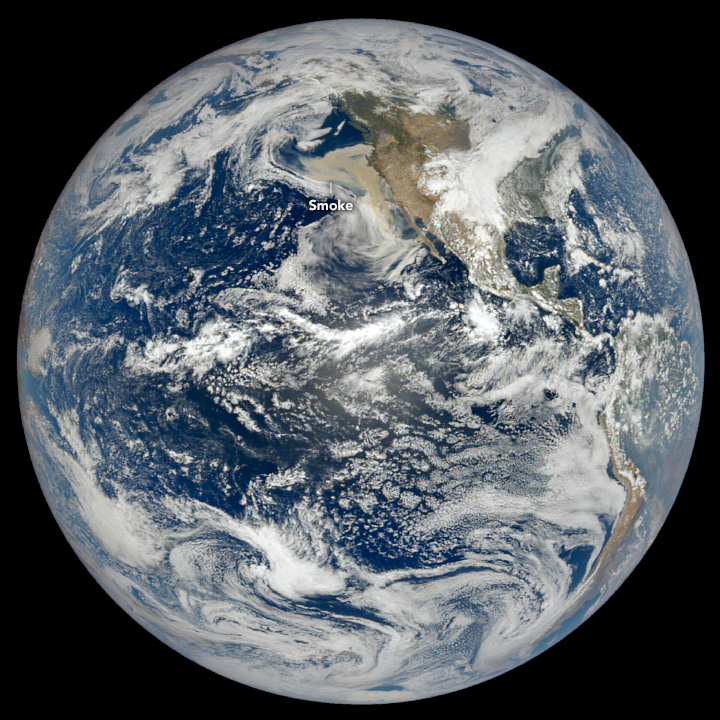
The smoke was so thick and widespread that it was easily visible from 1.5 million kilometers (1 million miles) away from Earth. When NASA’s Earth Polychromatic Imaging Camera (EPIC) on NOAA’s DSCOVR satellite acquired the image below, large areas of Oregon, California, and the northeastern Pacific Ocean were obscured by smoke.
References & Resources
- CalFire (2020, September 10) Incidents. Accessed September 10, 2020.
- Environmental Protection Agency (2020, September 10) National Map. Accessed September 10, 2020.
- InciWeb (2020, September 10) Incident Information System. Accessed September 10, 2020vi.
- NOAA Storm Prediction Center (2020, September 10) Fire Weather Outlook. Accessed September 10, 2020.
- National Weather Service (2020, September 10) Short Range Public Discussion. Accessed September 10, 2020.
- Northwest Interagency Coordination Center (2020, September 10) 9/10/2020 NWCC Morning Brief. Accessed September 10, 2020.
- The Oregonian (2020, September 10) Oregon Wildfires. Accessed September 10, 2020
- San Francisco Chronicle (2020, September 10) California Wildfires. Accessed September 10, 2020
NASA Earth Observatory images by Lauren Dauphin, using MODIS data from NASA EOSDIS/LANCE and GIBS/Worldview and data from DSCOVR EPIC . Caption by Adam Voiland .