


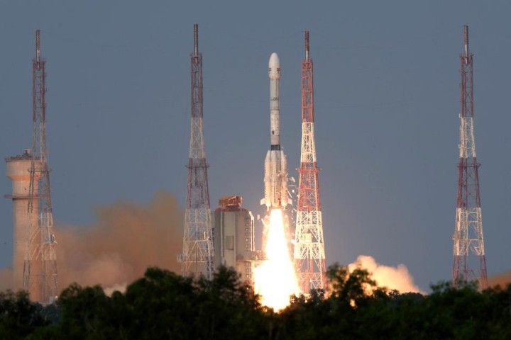
Carrying an advanced radar system that will produce a dynamic, three-dimensional view of Earth in unprecedented detail, the NISAR (NASA-ISRO Synthetic Aperture Radar) satellite launched from Satish Dhawan Space Centre in Sriharikota, Andhra Pradesh, India, on July 30, 2025.
The satellite, jointly developed by NASA and the Indian Space Research Organisation (ISRO), can detect the movement of land and ice surfaces down to the centimeter. The mission will help protect communities by providing unique, actionable information to decision-makers in a diverse range of areas, including disaster response, infrastructure monitoring, and agricultural management.
This photo is one in a series of images taken by ISRO as the satellite lifted off aboard an ISRO Geosynchronous Satellite Launch Vehicle (GSLV) rocket at 8:10 a.m. EDT (5:10 p.m. IST) on July 30. The ISRO ground controllers began communicating with NISAR about 20 minutes after launch, at just after 8:29 a.m. EDT, and confirmed it is operating as expected.
From 747 kilometers (464 miles) above Earth, NISAR will use two advanced radar instruments to track changes in Earth’s forests and wetland ecosystems, monitor deformation and motion of the planet’s frozen surfaces, and detect the movement of Earth’s crust down to fractions of an inch—a key measurement in understanding how the land surface moves before, during, and after earthquakes, volcanic eruptions, and landslides.
The mission’s two radars will monitor nearly all the planet’s land- and ice-covered surfaces twice every 12 days, including areas of the polar Southern Hemisphere rarely covered by other Earth-observing radar satellites. And unlike optical sensors, NISAR will be able to “see” through clouds, making it possible to monitor the surface during storms, as well as in darkness and light.
In the coming weeks, the spacecraft will begin a roughly 90-day commissioning phase during which it will deploy its 12-meter (39-foot) radar antenna reflector. This reflector will direct and receive microwave signals from the two radars. By interpreting the differences between the two, researchers can discern characteristics about the surface below. As NISAR passes over the same locations twice every 12 days, scientists can evaluate how those characteristics have changed over time to reveal new insights about Earth’s dynamic surfaces.
References & Resources
- Indian Space Research Organisation, Department of Space (2025) NISAR–NASA ISRO Synthetic Aperture Radar Mission. Accessed July 30, 2025.
- NASA Missions (2025) NISAR (NASA-ISRO Synthetic Aperture Radar). Accessed July 30, 2025.
- NASA News Releases (2025, July 30) NASA-ISRO Satellite Lifts Off to Track Earth’s Changing Surfaces. Accessed July 30, 2025.
- NASA’s Jet Propulsion Laboratory (2025, July 21) 5 Things to Know About Powerful New U.S.-India Satellite, NISAR. Accessed July 30, 2025.
Photo courtesy of the Indian Space Research Organisation (ISRO). Text adapted from materials provided by NASA’s Jet Propulsion Laboratory .
None


