After roiling off Australia’s northeast coast for over a week, Tropical Cyclone Alfred was poised to make landfall near Brisbane, the country’s third-most populous city, in early March 2025. It is rare for a tropical cyclone to hit Australia’s east coast this far south. The last one to reach land near the Queensland–New South Wales border was Tropical Cyclone Zoe in 1974.
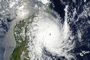
Alfred was the equivalent of a tropical storm as classified by the U.S. National Weather Service, or a Category 2 storm on the Australian tropical cyclone intensity scale, as it crept toward the coast on March 7. The VIIRS (Visible Infrared Imaging Radiometer Suite) on the NOAA-21 satellite captured this image of the storm around 1:30 p.m. local time (03:30 Universal Time) on that day.
Despite its relatively low classification on the storm scales, Alfred posed serious hazards to areas in its path. Its slow pace exacerbated the damaging effects, allowing heavy rains, storm surge, and high winds to lash heavily populated coastal areas for several days leading up to landfall. Sustained wind speeds of 80 kilometers (50 miles) per hour were observed around the time this image was acquired.
The tropical cyclone formed over the Coral Sea approximately 1,300 kilometers (800 miles) north of Brisbane on February 22. At one point, Alfred coexisted in the South Pacific with two other tropical cyclones, Seru and Rae. It tracked south and southeast for about a week, intensifying for a period but staying offshore. Cyclones in this area often continue along that trajectory and peter out over the ocean.
Initial forecasts predicted Alfred would remain offshore. However, on March 4, it made a sharp turn to the west, steered by a high-pressure ridge to the south. Coral Sea cyclones are difficult to predict, experts say: compared with other ocean basins, the region sees more complex winds and weather systems that can push storms around.
The winds steering Alfred toward land were relatively weak, observers noted, which caused it to move slowly and prolong its effects on the coast. Energy from anomalously high sea surface temperatures in the northeast Coral—some of the warmest recorded for the months of January and February—also helped to fuel the storm system.
Alfred brought heavy rain and wind to populated areas, including Brisbane, Gold Coast, and Byron Bay. Weather stations south of Brisbane recorded over 100 millimeters (4 inches) of rain in the week ending on March 6. Large swells and powerful waves pummeled the Queensland coast for several days preceding landfall, causing coastal erosion and inundation, according to Australian Bureau of Meteorology officials. Rain and winds would intensify as the storm crossed, meteorologists said, and the bureau issued major flood warnings for multiple rivers.
References & Resources
- ABC News (2025, March 4) What’s unusual about Cyclone Alfred, and is climate change affecting how it moves towards the coast? Accessed March 7, 2025.
- Australian Bureau of Meteorology (2025, March 7) Severe Weather Update 7 March 2025: Tropical Cyclone Alfred Friday afternoon update. Accessed March 7, 2025.
- The Conversation (2025, March 5) Cyclone Alfred is slowing – and that could make it more destructive. Here’s how climate change might have influenced it. Accessed March 7, 2025.
- The Conversation (2025, March 2) Cyclone Alfred is expected to hit southeast Queensland – the first in 50 years to strike so far south. Accessed March 7, 2025.
- The Guardian (2025, March 6) States prepare for cyclone flooding as authorities urge ‘do not underestimate this storm’. Accessed March 7, 2025.
- NASA Earth Observatory (2025, February 28) Cyclone Flurry in the Southern Hemisphere. Accessed March 7, 2025.
- Prime Minister of Australia (2025, March 5) Press conference - Brisbane. Accessed March 7, 2025.
- Weather Underground (2025, March 7) Tropical Cyclone Alfred. Accessed March 7, 2025.
NASA Earth Observatory image by Wanmei Liang , using VIIRS data from NASA EOSDIS LANCE , GIBS/Worldview , and the Joint Polar Satellite System (JPSS) and cyclone track data from Weather Underground. Story by Lindsey Doermann .


