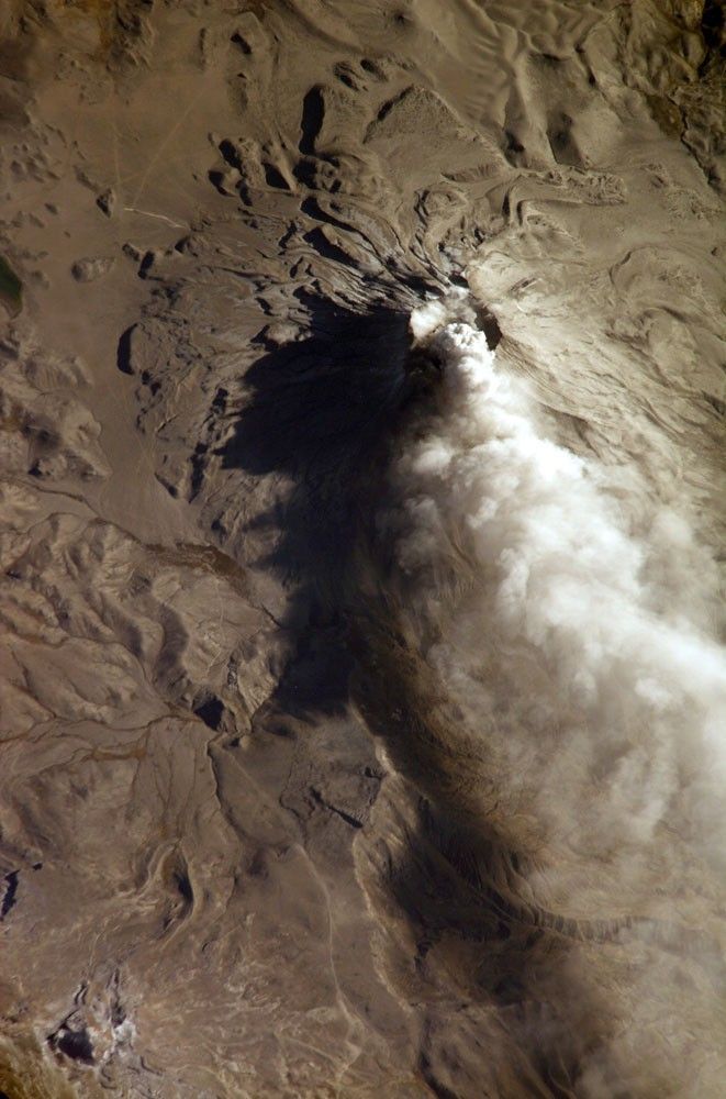
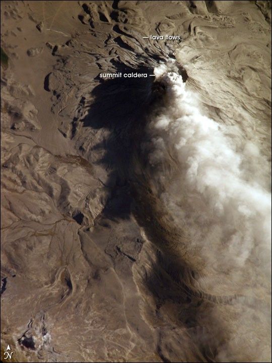
Subduction of the Nazca tectonic plate along the western coast of South America forms the high Peruvian Andes. The subduction (movement of one plate beneath another) also produces magma, feeding a chain of historically active volcanoes along the western front of the mountains. The most active of these volcanoes in Peru is Ubinas. A typical, steep-sided stratovolcano comprised primarily of layers of silica-rich lava flows, it has a summit elevation of 5,672 meters (18,609 feet). At 1.4 kilometers (0.87 miles) across, the volcano’s caldera gives it a truncated profile. Hardened lava flows from past eruptions linger on the volcano’s flanks.
This oblique image (looking at an angle) from the International Space Station (ISS) captures an ash cloud first observed on satellite imagery at 11:00 GMT on August 14, 2006. An ISS astronaut took this picture one hour and 45 minutes later. The ash cloud caused the Buenos Aires Volcanic Ash Advisory Center to issue an aviation hazard warning. Minor to moderately explosive eruptions of ash and pumice characterize modern activity at Ubinas. Pumice and ash blanket the volcanic cone and surrounding area, giving this image an overall gray appearance. Shadowing of the western flank of Ubinas throws several lava flows into sharp relief, and highlights the steep slopes at the flow fronts—common characteristics of thick, slow-moving lavas. The most recent major eruption of Ubinas occurred in 1969, although its historical record of activity extends back to the 16th century.
References & Resources
Astronaut photograph ISS013-E-66488 was acquired August 14, 2006, with a Kodak 760C digital camera using an 800 mm lens, and is provided by the ISS Crew Earth Observations experiment and the Image Science & Analysis Group, Johnson Space Center. The image in this article has been cropped and enhanced to improve contrast. Lens artifacts have also been removed. The International Space Station Program supports the laboratory to help astronauts take pictures of Earth that will be of the greatest value to scientists and the public, and to make those images freely available on the Internet. Additional images taken by astronauts and cosmonauts can be viewed at the NASA/JSC Gateway to Astronaut Photography of Earth.