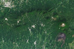
May 19, 2016
On May 19, 2016, ash drifted above Fuego, one of Central America’s most active volcanoes. The volcano is located about 70 kilometers (40 miles) west of Guatemala City, Guatemala. The ash column was some 5,000 meters (18,000 feet) above sea level, according to news reports. On May 19, 2016, the Operational Land Imager (OLI) on Landsat 8 captured this image of ash just southwest of the volcano. Though it looks similar to other clouds in the scene, the ash is slightly darker.
References & Resources
- Global Volcanism Program Feugo. Accessed May 19, 2016.
- RT (2016, May 18) ‘Volcano of Fire’ erupts in Guatemala, prompting evacuations. Accessed May 19, 2016.
- Volcano Discovery (2016) Fuego volcano (Guatemala). Accessed May 19, 2016.
NASA Earth Observatory image by Jesse Allen, using Landsat data from the U.S. Geological Survey. Caption by Adam Voiland.