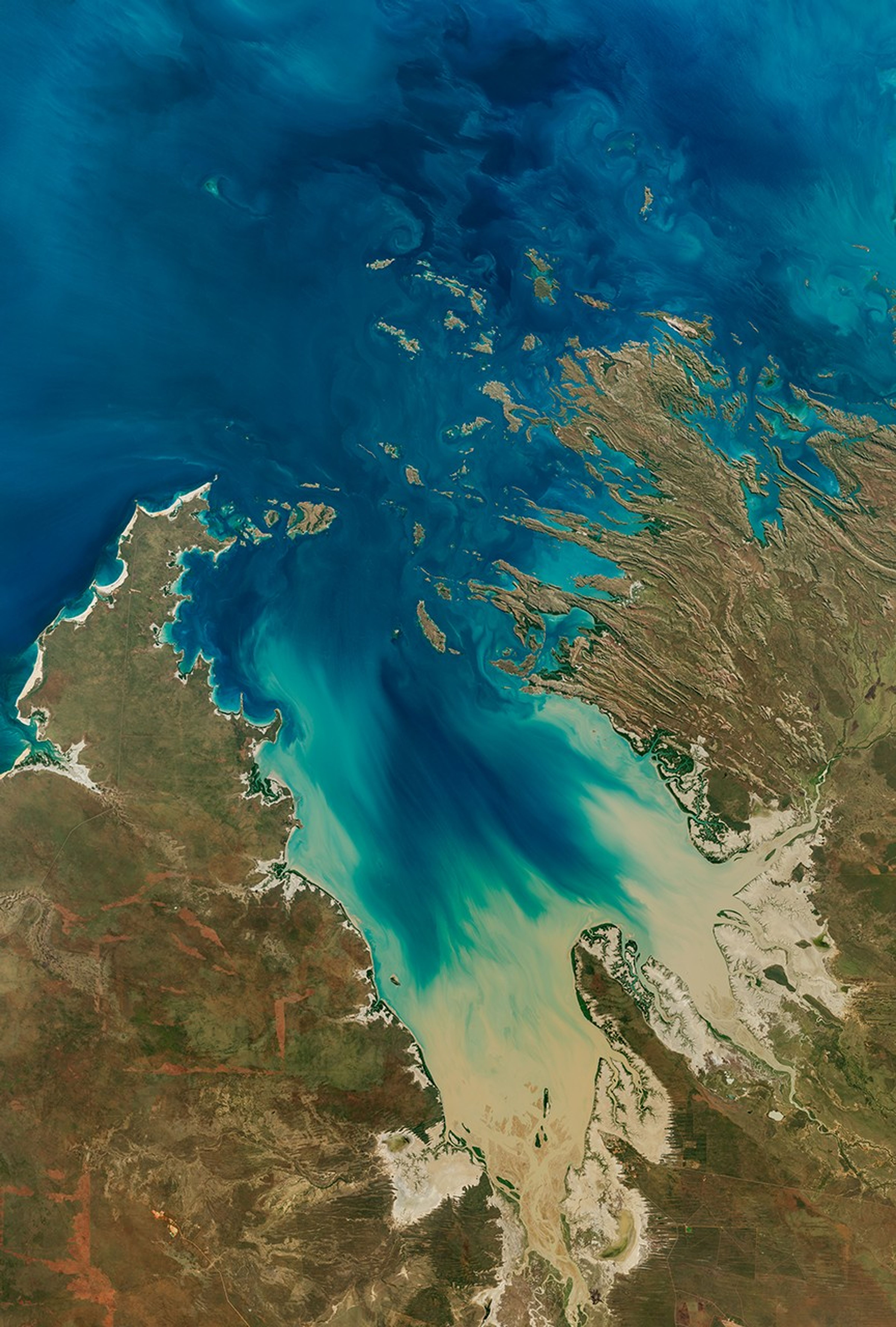


In the sparsely populated Kimberley region of Western Australia, jagged landforms reach like fingers into the turquoise-blue ocean waters. Along the coastline north of Derby, they used to reach even farther. But rising sea levels submerged part of the coastal landscape, giving rise to hundreds of islands and low-lying reefs that compose the Buccaneer Archipelago.
The OLI-2 (Operational Land Imager) on Landsat 9 captured this image of the archipelago on June 11, 2025. The scene encapsulates the striking interactions between land and water in the area where King Sound opens to the Indian Ocean.
Water whips around the islands with the ebb and flow of the tides. When this image was acquired at around 9:50 a.m. local time (01:50 Universal Time), the water had recently passed the day’s first low tide (2.54 meters) and was several hours away from high tide (10.61 meters). The islands lie along a part of the Kimberley coast known for extreme tidal ranges that can approach 12 meters.
The powerful tidal currents stir up sediment in shallow areas, producing the beautiful turquoise swirls visible in this image. This power, however, can be hazardous to seafarers and divers as water rips through the archipelago’s constricted passages. One infamous place of turbulence, known as “Hell’s Gate,” lies in the passage between Gerald Peninsula and Muddle Islands.
Coastal areas are equally striking, displaying an array of green mangrove estuaries and bright sandy beaches. For instance, Silica Beach (Ngalangalangarr) on Hidden Island’s north side is named for its bright white grains of silica quartzite. Development is limited throughout the area, though mining activities and related infrastructure, including airstrips, are visible on Koolan Island and nearby Cockatoo Island.
Although the archipelago is sparsely populated, Aboriginal people have lived in the region for thousands of years. Today, they maintain a close connection with their traditional lands. For instance, three marine parks established in 2022—Mayala, Bardi Jawi Gaarra, and Lalang-gaddam—were the first in Western Australia to be co-designed and jointly vested with Traditional Owners.
References & Resources
- Government of Western Australia, Department of Biodiversity, Conservation and Attractions Bardi Jawi Gaarra Marine Park. Accessed July 24, 2025.
- Government of Western Australia, Department of Biodiversity, Conservation and Attractions Lalang-gaddam Marine Park. Accessed July 24, 2025.
- Government of Western Australia, Department of Biodiversity, Conservation and Attractions Mayala Marine Park. Accessed July 24, 2025.
- Government of Western Australia: Marine Waters (2025, April 17) Fact Sheet: Buccaneer Archipelago. Accessed July 24, 2025.
- NASA Earth Observatory (2024, June 17) Turbulent Beauty Along the Kimberley Coast. Accessed July 24, 2025.
- NASA Earth Observatory (2017, June 16) Tracking the Hide-and-Seek Game Between Beaches and Tides. Accessed July 24, 2025.
NASA Earth Observatory image by Michala Garrison, using Landsat data from the U.S. Geological Survey . Story by Kathryn Hansen.