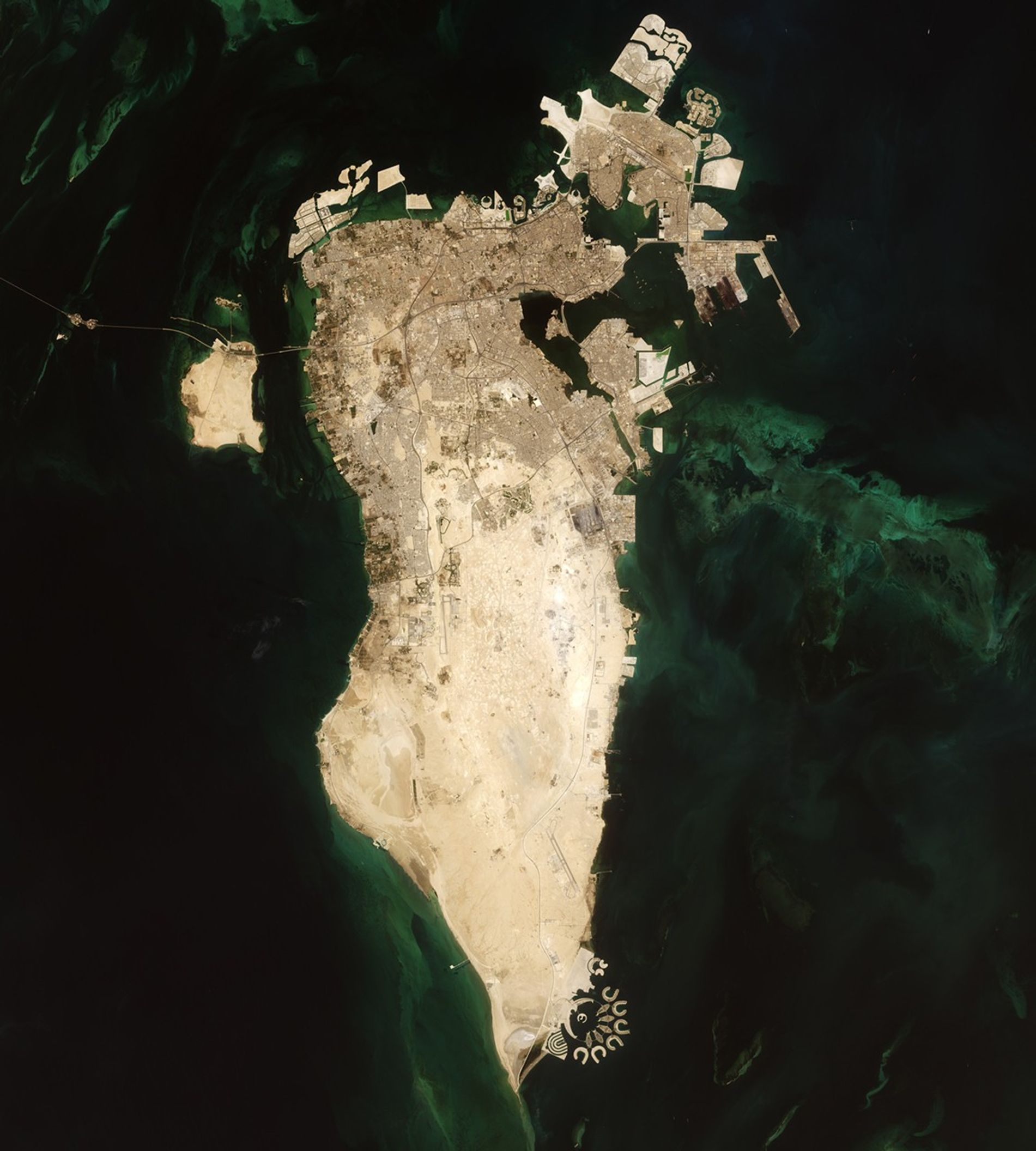


August 17, 1987-August 17, 2022
Building Bahrain
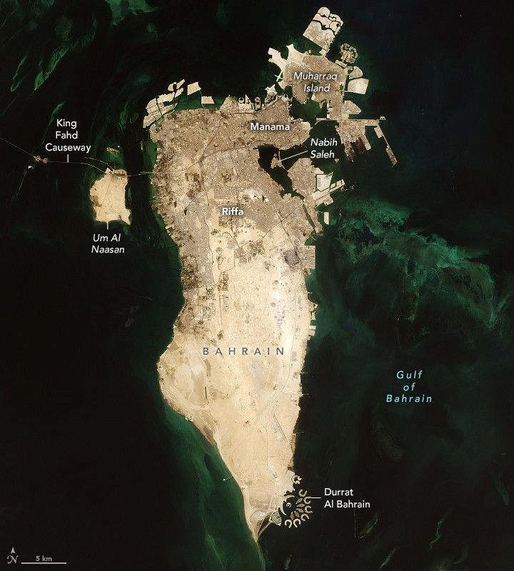
Bahrain is a small country with a big population. Both have been growing larger in recent decades.
Since the early 1980s, the population of this island nation in the Persian Gulf has quadrupled. In 2022, it reached 1.5 million. As population density has increased and urban development has spread, the need for land has grown.
“Like other countries in the [Persian] Gulf, rapid population growth and the simultaneous increase in urbanization, along with land scarcity, has pushed Bahrain to invest in mega land reclamation projects to extend its coastline,” said Eman Ghoneim, a physical geographer at the University of North Carolina Wilmington.
These images show changes across 35 years. The first image was captured by the Thematic Mapper on Landsat 5 on August 17, 1987. The second image, captured by the Operational Land Imager (OLI) on Landsat 8, shows the same area on August 17, 2022.
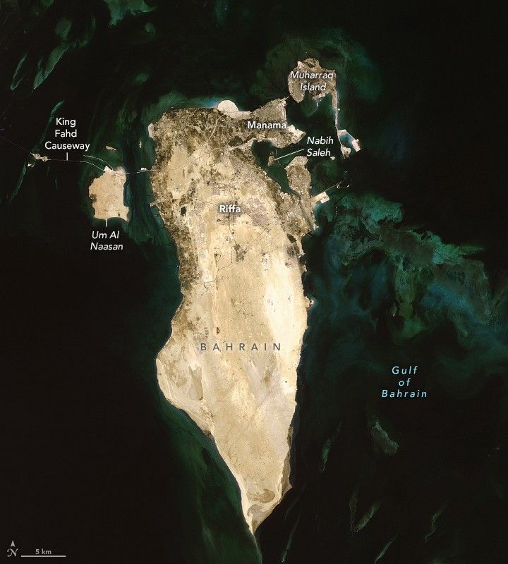
In 1987, Bahrain Island had just recently been linked to Saudi Arabia via the King Fahd Causeway, which opened in 1986. In July 2022, a record 2.5 million motor vehicle passengers traveled on the 25-kilometer (16-mile) stretch of road, according to news reports.
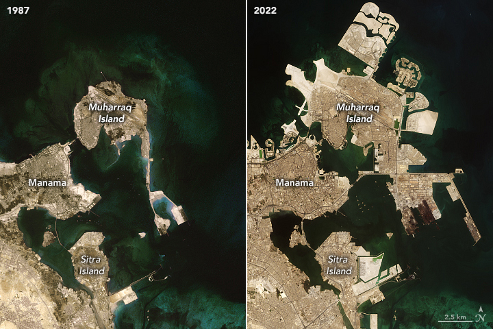
Change is most apparent in the country’s north, where shallow coastal waters have made it technically and economically feasible to build new land from the seafloor. Notice the areal expansion of existing islands, as well as the addition of new ones.
Sabah Aljenaid, a geographic information systems and remote sensing scientist at Arabian Gulf University, used Landsat images to classify changes to the land between 1986 and 2020. Aljenaid and colleagues found that built-up (urban) areas dominated the changes during this period, increasing on average by 7.5 percent each year. The growth came primarily at the expense of vegetated land and wetlands.
Aljenaid pointed out the dramatic expansion of Muharraq Island, which now spans more than 60 square kilometers (23 square miles) northeast of Manama, the capital city. She also pointed to changes on the island of Nabih Saleh, which has lost its agricultural areas.
While urban expansion has been focused in the north, parts of the southern coastline have undergone change, too. Dredging for the artificial islands of Durrat Al Bahrain began in 2004; by 2007, about 5 square kilometers (2 square miles) of land had been added to Bahrain’s southeast coast.
“A decade ago, I wrote that 11 percent of the island of Bahrain is reclaimed land, and the growth continues today,” said John Burt, a marine biologist at New York University Abu Dhabi. The shape of Bahrain in 35 more years remains to be seen. “There was on-and-off again talk of building a bridge across Fasht Al Adhm to Qatar,” Burt said. “It has not come to fruition, but it may be a future mega-development to watch out for.”
References & Resources
- AAAS (2014) Geospatial Technologies and Human Rights Project. Accessed September 6, 2022.
- AAAS (2014, April 21) AAAS Analysis Finds Major Changes in Land Use and Land Cover in Bahrain. Accessed September 6, 2022.
- Alburshaid, E. A. et al. (2021) Spatio-temporal land use analysis and urban growth dynamic prediction in the kingdom of Bahrain. 3rd Smart Cities Symposium (SCS 2020).
- Aljenaid, S. S. et al. (2022) Detecting and Assessing the Spatio-Temporal Land Use Land Cover Changes of Bahrain Island During 1986–2020 Using Remote Sensing and GIS. Earth Systems and Environment.
- CIA World Factbook (2022, August 30) Bahrain. Accessed September 6, 2022.
- The Economist (2022, June 9) Gulf states have spent billions to build cities in the sea. Accessed September 6, 2022.
- Gulf News (2022, August 4) Record 2.5m passengers on King Fahd Causeway in July. Accessed September 6, 2022.
- Landsat Science (2014, April 22) Looking at Urban Expansion in Bahrain. Accessed September 6, 2022.
- United Nations Development Programme (2018, December 4) Bahrain Human Development Report 2018. Accessed September 6, 2022.
- U.S. Geological Survey (2021) Bahrain. Accessed September 6, 2022.
- U.S. Geological Survey (2021) Manama. Accessed September 6, 2022.
NASA Earth Observatory images by Lauren Dauphin, using Landsat data from the U.S. Geological Survey . Story by Kathryn Hansen .