


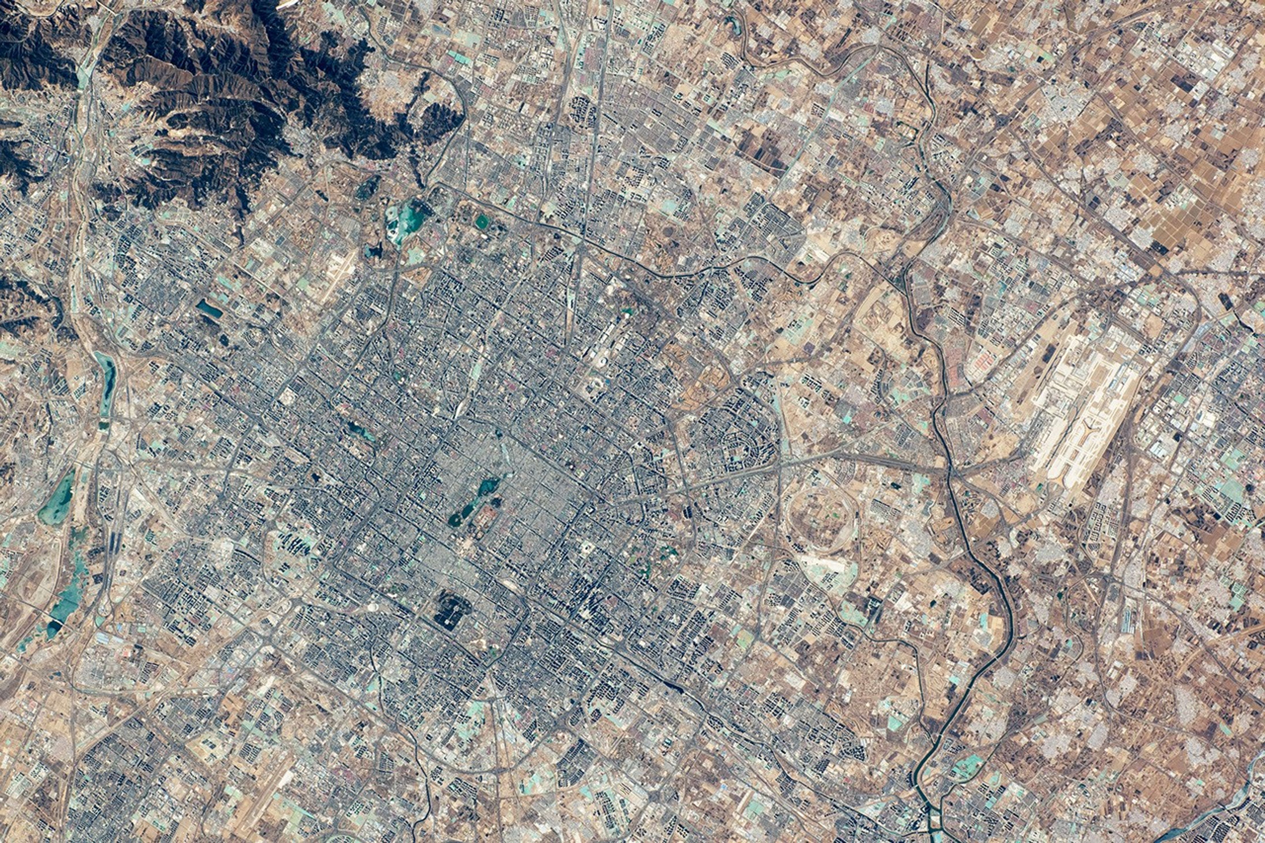
An astronaut aboard the International Space Station took this photo of Beijing, China’s capital city. Beijing appears gray, with the oldest, central part of the city in the middle. Wooded foothills (dark brown) lie to the northwest. Outlying districts, including suburbs, zones of light industry, and small towns, present lighter tones. Beijing is China’s second-largest city, following Shanghai, with 16 districts estimated to include 21.2 million people in 2024.
The old central part of the city, as seen from space (center-left), appears even lighter gray than the slightly darker tone of the wider urban landscape. The effect is due to the low buildings in the old city that cast less shadow than the taller buildings in the newer developments. This is a common phenomenon in detailed astronaut images of cities; darker tones are typical of high-rise neighborhoods (for example, in Manhattan).
Some details within the oldest part of the city are easier to see in the high-resolution version of this image, such as the defensive moat (dark line) that surrounds the old city. Other dark features in the old city include ornamental lakes and a large park immediately next to the 2nd Ring Road. A small, lighter-toned patch at the center of the old city is China’s imperial palace (also known as the Forbidden City). This palace is hundreds of years old and has been declared a UNESCO World Heritage site.
Patterns of transportation networks are a common feature in astronaut images. Beijing’s road system is known for its eight concentric rings surrounding the urban area. Six of these ring roads can be identified in the image. The 2nd Ring Road follows the ancient moat around the old central zone, and the 5th Ring Road encloses the densely built-up neighborhoods.
One of the biggest radial highways, cutting across the ring-road system, connects the city center to Beijing’s Capital International Airport, located 32 kilometers (20 miles) to the east. The 6th Ring Road passes just outside the airport.
High-speed railways connect Beijing to many major cities in China. One of these railroads appears near the bottom of the image, between the 2nd and 4th Ring Roads. The Yongding River flows along the city’s western margin, and the Wenyu River flows along the city’s east. Both supply water to the waterways, canals, and green areas across the city.
References & Resources
Astronaut photograph ISS070-E-93528 was acquired on February 15, 2024, with a Nikon D5 digital camera using a focal length of 240 millimeters. It is provided by the ISS Crew Earth Observations Facility and the Earth Science and Remote Sensing Unit, Johnson Space Center. The image was taken by a member of the Expedition 70 crew . The image has been cropped and enhanced to improve contrast, and lens artifacts have been removed. The International Space Station Program supports the laboratory as part of the ISS National Lab to help astronauts take pictures of Earth that will be of the greatest value to scientists and the public, and to make those images freely available on the Internet. Additional images taken by astronauts and cosmonauts can be viewed at the NASA/JSC Gateway to Astronaut Photography of Earth . Caption by Justin Wilkinson, Texas State University, JETS II Contract at NASA-JSC.


