


The MODIS instrument onboard NASAâs Aqua satellite detected widespread fire activity on the islands of Borneo and Sumatra. The burning of biomass produces, among other pollutants, high amounts of carbon monoxide (CO) which is detected by the Measurements of Pollution in the Troposphere (MOPITT) instrument launched on board the Terra satellite in December 1999.
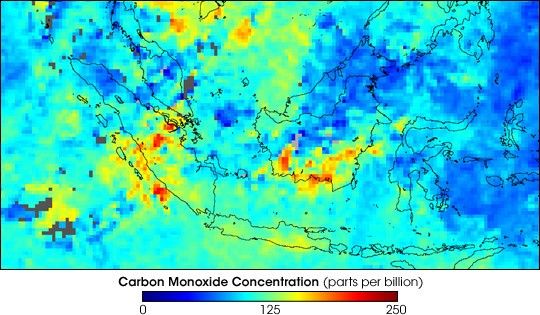
The false-color image below shows the atmospheric carbon monoxide concentrations at 700 hPa (about 3 km altitude) over Borneo averaged for September 15 - October 15, 2004. Only data collected during daytime have been included in this image. Carbon monoxide retrievals from daytime observations are, compared to retrievals from nighttime observations, more sensitive to CO concentrations at lower altitudes and better represent the location of sources. Regions with high amounts of CO are represented in red and yellow colors and correlate well with the location of the MODIS fire counts. Areas where no data have been collected due to persistent cloud coverage are shown in gray.
References & Resources
NASA image created by Jesse Allen, Earth Observatory, using data provided courtesy of the NCAR and University of Toronto MOPITT teams.


