


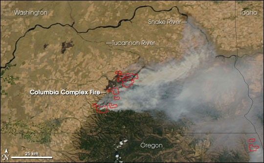
In the southeastern corner of Washington, where the Blue Mountains slope down to the Snake River plain, a large fire was burning on August 23, 2006, when the Moderate Resolution Imaging Spectroradiometer (MODIS) on NASA’s Aqua satellite passed overhead and captured this image. Places where the sensor detected atively burning fires are outlined in red. The fire is the Columbia Complex Fire, and according to reports from the National Interagency Fire Center on August 24, the fire was threatening residences, a watershed, and fisheries. The fire had burned 34,000 acres and was completely uncontained.
The high-resolution image provided above has a spatial resolution of 250 meters per pixel. The MODIS Rapid Response System provides images of the entire western United States at additional resolutions.
References & Resources
NASA image courtesy the MODIS Rapid Response Team, Goddard Space Flight Center


