

In the second week of August 2008, the western Oklahoma Panhandle got just enough rain to ease the region’s drought status from “exceptional” to “extreme“ according to the U.S. Drought Monitor report from August 12. The area had been suffering through a drought since fall 2007; in terms of dryness, the year rivaled conditions the area faced during the Dust Bowl years.
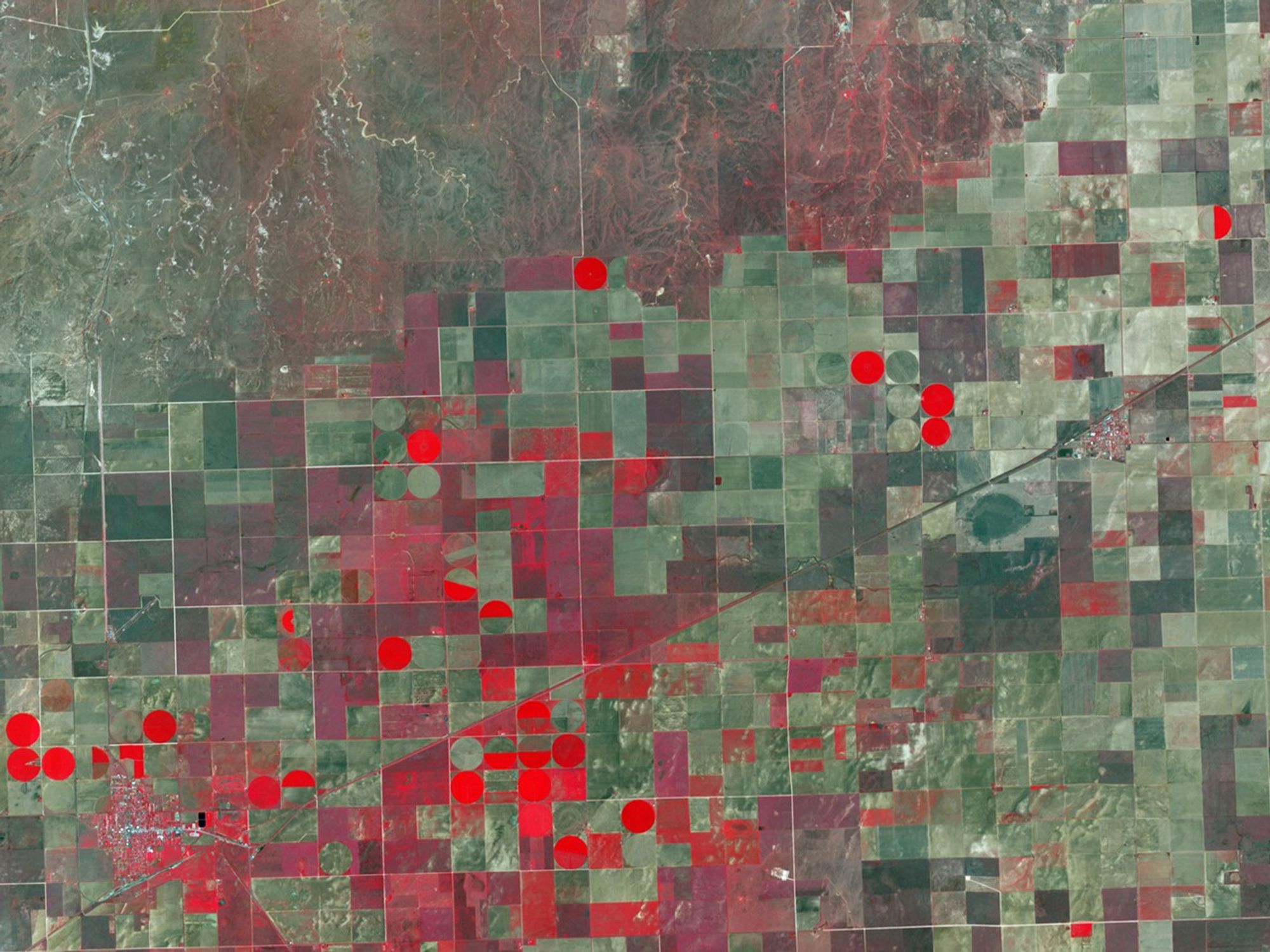
The scattered August rains may be responsible for some of the vegetation patterns recorded by the Advanced Spaceborne Thermal Emission and Reflection Radiometer (ASTER) on NASA’s Terra satellite in this image from August 14, 2008. The image uses a combination of visible and infrared light to enhance the appearance of vegetation, which looks red. Places where vegetation is dead or dormant are shades of beige to gray. Very reflective surfaces, such as roads and dry creek beds are off-white. The small farming towns of Boise City and Keyes are separated by a patchwork of geometric fields.
The most robust vegetation occurs in fields with center-pivot irrigation, usually corn in this part of Oklahoma, but sometimes milo, sorghum for livestock feed, or cotton, according to Cherri Brown, district conservationist for the USDA Natural Resources Conservation Service in Boise City. The other circular fields could be residue from harvested crops, but they could also be places where crops have succumbed to drought. Most of the rectangular fields are being prepared for seeding of wheat or are planted with milo and sorghum feed crops. Many of the fields are streaked or marbled with bright, sandy-looking patches. Narrow, straight lines may be cultivation patterns, but the more blotchy-looking areas may be places where the death of vegetation has allowed the region’s sandy soils to blow and drift.
North of the cropland, the landscape transitions to prairie, much of which is used as grazing land. The health of vegetation on these lands is variable. In places, the landscape is gray and brown, indicating dead or dormant grasses. But across some areas, there is a faint tinge of red, indicating some plants are surviving the drought. These variations could be due to a combination of patchy rainfall, topography, and soils.
To learn more about the region’s drought, please read the feature story Devastating Drought Settles on the High Plains.
References & Resources
- References
- U.S. Drought Mitigation Center. (2008, August 12). National Drought Summary—August 12, 2008. Accessed August 18, 2008.
NASA image created by Jesse Allen, using data provided courtesy of NASA/GSFC/METI/ERSDAC/JAROS, and U.S./Japan ASTER Science Team. Caption by Rebecca Lindsey.