


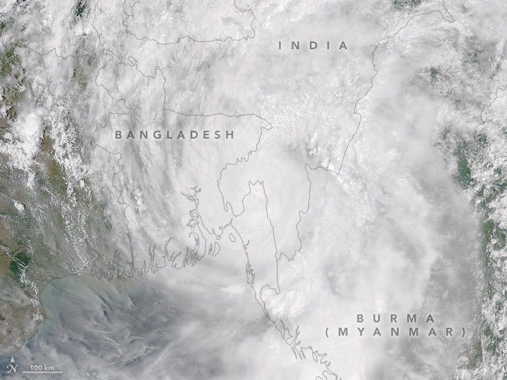
Cyclone Mora pummeled Bangladesh with high winds and heavy rain on May 30, 2017. The Moderate Resolution Imaging Spectroradiometer (MODIS) on NASA’s Aqua satellite captured this natural-color image of the cyclone that day.
Maximum wind speeds reached 120 kilometers (75 miles) per hour, according to the Global Disaster Alert and Coordination System. The organization reported that more than 11 million people were affected by winds equivalent to a category 1 hurricane—strong enough to cause damage to houses, crops, and trees.
Millions of people live in the low-lying coastal regions of Bangladesh, India, and Myanmar. Authorities in Bangladesh oversaw large-scale evacuations as storm winds battered the coast, local news sites reported. Cox’s Bazar, the town where Mora made landfall, was especially hard hit, with damage to thousands of structures, according to news reports.
In its final warning, the Joint Typhoon Warning Center reported that Mora should dissipate as it moves into rough terrain over northeast India.
References & Resources
- Global Disaster Alert and Coordination System - GDACS (2017, May 30) Overall Red Tropical Cyclone alert for MORA-17 in Bangladesh, India from 27 May 2017 18:00 UTC to 30 May 2017 06:00 UTC. Accessed May 30, 2017.
- Joint Typhoon Warning Center (2017, May 30) Tropical Cyclone 02B (Mora) Warning NR 011. Accessed May 30, 2017.
- ReliefWeb (2017, May 30) Tropical Cyclone Mora - 17. Accessed May 30, 2017.
- The Weather Channel (2017, May 30) Tropical Cyclone Mora Makes Landfall in Bangladesh; 3 Killed, Thousands of Homes Destroyed. Accessed May 30, 2017.
NASA Earth Observatory image by Jesse Allen, using data from the Land Atmosphere Near real-time Capability for EOS (LANCE). Story by Pola Lem.


