


September 3, 2024
Delaware’s Tidal Wetlands
In the low-lying reaches of Delaware, the land breathes with the ebb and flow of the tide. These tides support the marshes (tidal wetlands) lining much of Delaware Bay.
Marshes are one of several wetland types that together cover about one-quarter of Delaware—the second-smallest U.S. state. These semi-aquatic ecosystems, which provide habitat for plants and animals, improve water quality, and help protect against flooding and erosion.
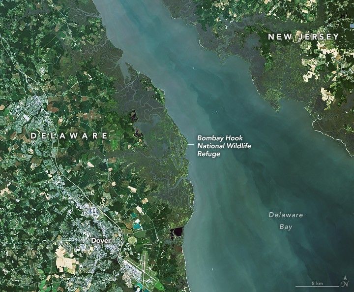
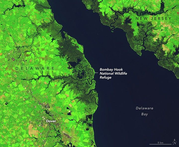
These images, acquired on September 3, 2024, with the OLI (Operational Land Imager) on Landsat 8, show a segment of the region’s coastal wetlands in Delaware and New Jersey. In the false-color image (right), open water appears dark blue, and low-lying areas inundated with water (marsh) appear dark blue-green. Farther inland, the vegetation in agricultural, forested, and urban areas appears bright green.
Tidal wetlands lie at the intersection of land and water, where the shore meets an ocean, bay, river, or stream. They regularly flood and drain with the rise and fall of the tides. When these images were acquired at about 11:40 a.m. local time (15:40 Universal Time), waters in the vicinity of the Leipsic River were approaching high tide.
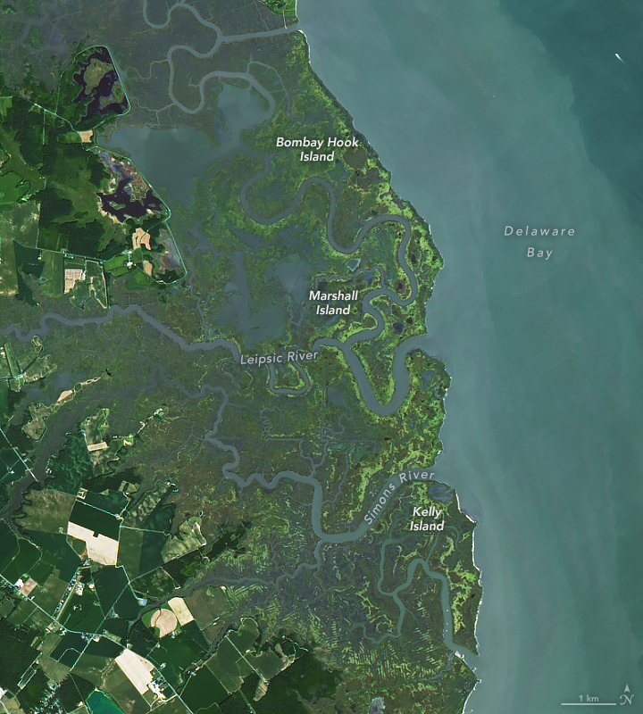
The Bombay Hook National Wildlife Refuge, centered in the images at the top of this page and shown in detail in the image above, protects 25 square miles (65 square kilometers) along the Delaware coast. About 20 square miles of that area is tidal salt marsh—one of the largest remaining expanses of the ecosystem in the mid-Atlantic, according to the U.S. Fish & Wildlife Service. Salt marsh hay (Spartina patens) grows here, providing habitat for animals and shorebirds.
Bombay Hook is one in a series of refuges located along the Atlantic Flyway. In September, birdwatchers visiting the refuge can see late-migrating shorebirds and songbirds and the arrival of the season’s first Canada geese. It’s also the time of year when tickseed sunflower, goldenrod, and Joe-Pye-weed are flowering.
Even protected tidal wetlands, however, can undergo marsh migration—a process in which rising sea levels drown a marsh and cause it to move inland. In 2021, researchers with NASA’s DEVELOP program used observations from several satellites to map Delaware’s marshes and project where these marshes are likely to migrate in the future. They found that between 2010 and 2020, the state lost nearly 7 square miles of coastal marshes; however, some sites—especially toward the middle of the coastline—are suitable for future marsh migration.
References & Resources
- Delaware.gov Delaware Wetlands Status and Trends. Accessed September 19, 2024.
- The Delaware Geological Survey (2020) Morphology and Tidal Inundation of Tidal Wetlands in the Delaware Estuary. Accessed September 19, 2024.
- Friends of Bombay Hook (2024) About the Refuge. Accessed September 19, 2024.
- NASA Applied Sciences Program (2021) Assessing Land Cover and Soil to Identify Suitable Sites for Tidal Marsh Migration in Delaware. Accessed September 19, 2024.
- NASA DEVELOP (2021) Delaware Ecological Forecasting. Accessed September 19, 2024.
- NASA DEVELOP (2021) Saving Tidal Wetlands. Accessed September 19, 2024.
- Partnership for the Delaware Estuary Wetlands Overview. Accessed September 19, 2024.
- U.S. Fish & Wildlife Service Bombay Hook National Wildlife Refuge. Accessed September 19, 2024.
- U.S. Fish & Wildlife Service - Coastal Program (2020, April) Delaware Bay Estuary Project. Accessed September 19, 2024.
- WHYY (2023, March 7) Novel method will help restore Delaware and New Jersey salt marshes. Accessed September 19, 2024.
NASA Earth Observatory images by Michala Garrison, using Landsat data from the U.S. Geological Survey . Story by Kathryn Hansen.


