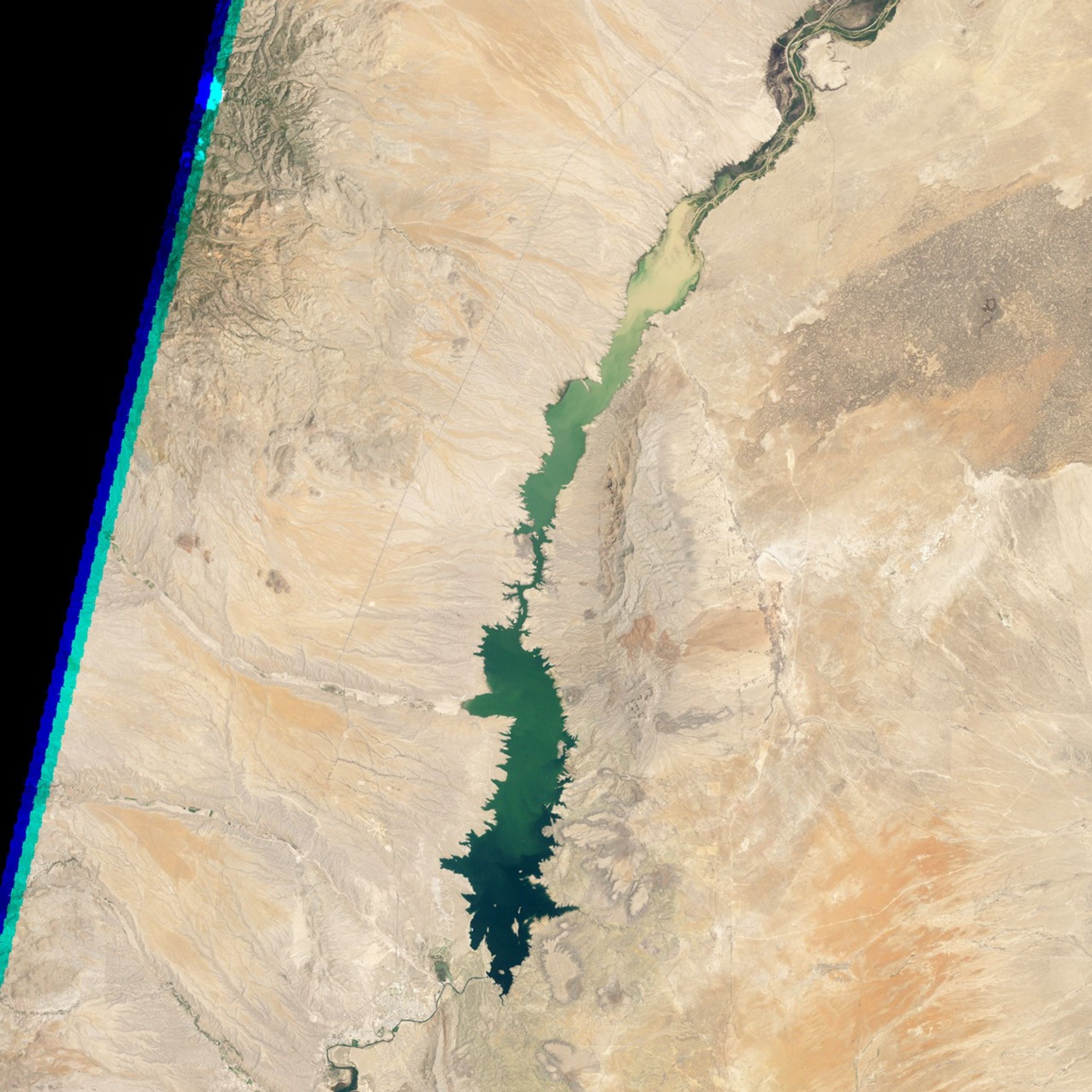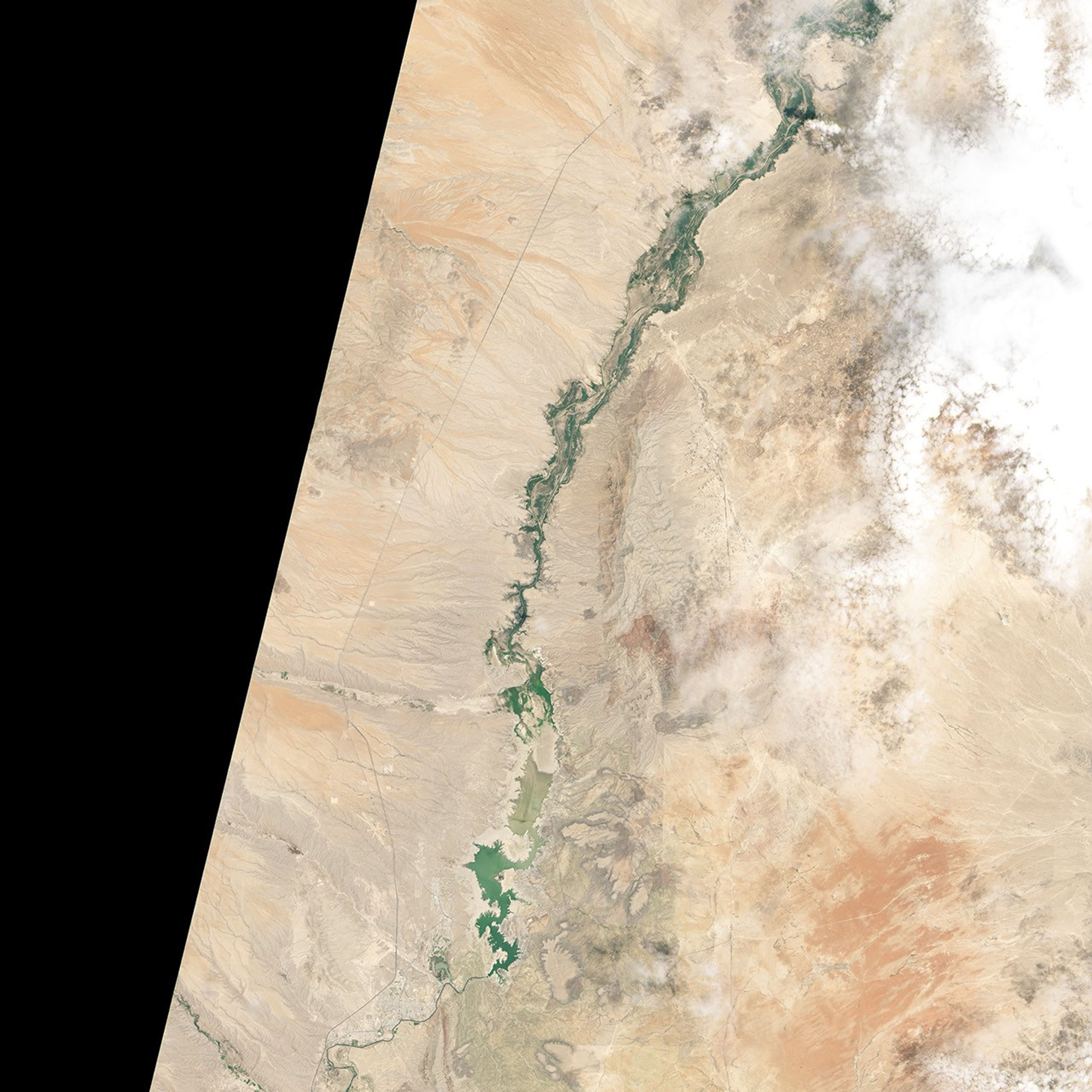


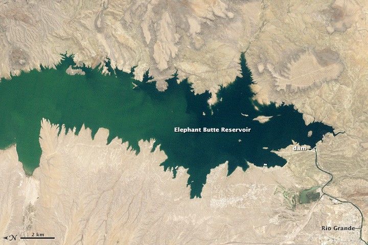

June 2, 1994-July 8, 2013
Drought Dries Elephant Butte Reservoir

In the summer of 2013, Elephant Butte Reservoir dwindled to its lowest level in forty years. By late July, despite the arrival of monsoon rains, the reservoir was still virtually empty.
Numbers from the U.S. Army Corps of Engineers estimated the total water in storage to be 65,057 acre-feet (0.08 cubic kilometers) on July 24, 2013, about 3 percent of the reservoir’s capacity of 2.2 million acre-feet (2.7 cubic kilometers). The last time water levels were that low was 1972, after droughts in the 1950s and 1960s depleted Elephant Butte. On the other hand, the reservoir was filled nearly to capacity for most of the period between 1985 and 2000.
Located in southern New Mexico and fed by the Rio Grande, Elephant Butte is New Mexico’s largest reservoir. Created in 1915 with the construction of the Elephant Butte Dam, the reservoir provides water for about 90,000 acres (364 square kilometers) of farmland and nearly half the population of El Paso, Texas.
Drought severely strained the system in 2013. Spring runoff from snowpack in the mountains was well below average, and anemic rains throughout the beginning of the year left 80 percent of New Mexico grappling with either “extreme” or “exceptional” drought (the two most severe categories). The arrival of rains from the southwestern monsoon in early July offered a burst of moisture. But the impact on water storage at Elephant Butte was minimal, according to the Albuquerque Journal.
The Operational Land Imager (OLI) aboard Landsat 8 acquired the bottom image of the parched reservoir on July 8, 2013, when it was filled to about 3 percent of capacity. The top image shows the reservoir on June 2, 1994, when it was at about 89 percent of capacity.
With such limited water supplies in 2013, farmers have faced the shortest irrigation season on record, receiving just three acre-inches (308 cubic meters) instead of three acre-feet (3,700 cubic meters) of water. To meet the demand, El Paso water authorities have had to drill new wells that tap underground aquifers. The city has also increased desalinization efforts and called for voluntary water conservation measures.
Further Reading
- NASA Earth Observatory Water Level in Lake Powell.
- Southwest Climate Change Network Coping with Drought on the Rio Grande. Accessed July 25, 2013.
- Southwest Climate Change Network Understanding the Southwestern Monsoon. Accessed July 25, 2013.
References & Resources
- ABQ Journal (2013, July 23) Summer rain still not enough. Accessed July 25, 2013.
- ABC 7 (2013, July 17) NM irrigation season officially over. Accessed July 25, 2013.
- Discover (2013, July 15) Drought Turns the Rio Grande Into The “Rio Sand.” Accessed July 25, 2013.
- El Paso Times (2013, February 2) Reservoir drying up: El Paso shifts from Rio Grande to well water. Accessed July 25, 2013.
- El Paso Times (2013, May 14) Dealing with drought: El Pasoans asked to start conserving water. Accessed July 25, 2013.
- Elephant Butte Irrigation District Water Supply Outlook - July 2013. Accessed July 25, 2013.
- National Drought Mitigation Center (2013, July 26) U.S. Drought Monitor: New Mexico. Accessed July 25, 2013.
- Sante Fe Reporter (2013, July 25) Time-Lapse Video: Rio Grande drying after the rain. Accessed July 25, 2013.
NASA Earth Observatory image by Jesse Allen and Robert Simmon, using Landsat data from the U.S. Geological Survey. Caption by Adam Voiland.