Today's story is part of our recent series Landsat Goes Over the Top: A Long View of the Arctic.
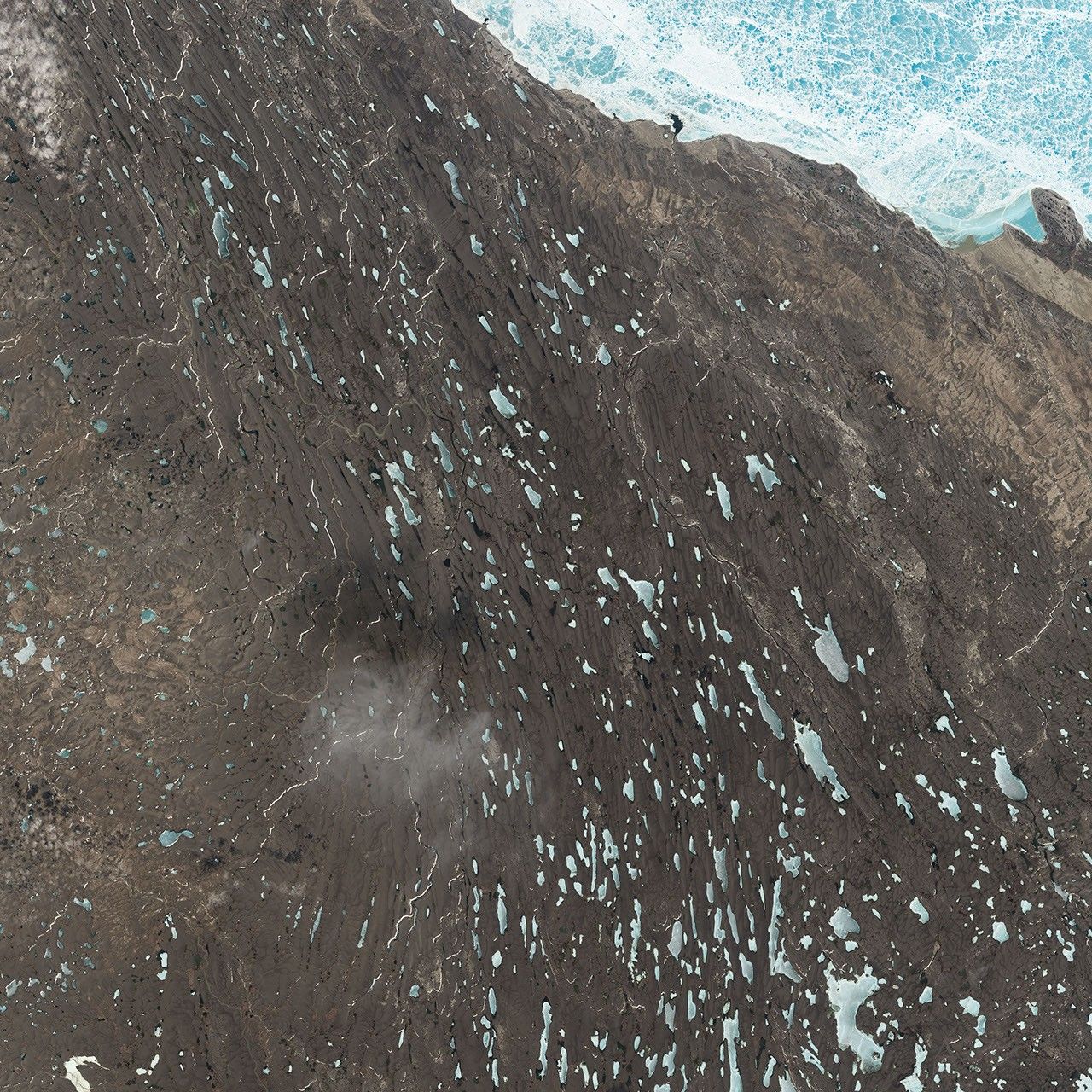
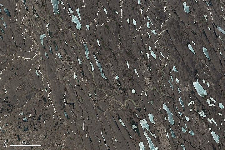
When glaciers retreat, they sometimes leave behind an enigmatic landform known as a drumlin field, an area of elongated hills aligned parallel to the flow of ice. While the word “drumlin” comes from the Gaelic and Irish term “druim”—“back” or “ridge”—the ridges pictured above are far from Ireland (though the landform does exist there).
On June 21, 2014, the Operational Land Imager (OLI) on Landsat 8 acquired this image of a drumlin field in the Nunavut Territory of Canada, about 27 kilometers (17 miles) southwest from Amundsen Gulf.
The drumlins and surrounding area seen here are thought to have been formed below the Laurentide Ice Sheet during the last Ice Age. The size and shape of the drumlins varies from small and egg-shaped to more elongated and asymmetrical. Such variability is common within drumlin fields around the world.
The field pictured above, however, appears to have more elongated forms than most. Researchers think it’s possible that the ice cover included a fast-flowing ice stream—an area of faster moving ice within the larger glacier. Most scientists agree that faster ice produces longer drumlins. Still, the nature of their complex shapes has challenged researchers to find a theory that explains all aspects of their formation.
In fact, drumlin researcher Rebecca Lee says that no one knows exactly how drumlins form. Competing theories include formation by water or ice flow, or some combination of the two. A more complete understanding of how drumlins form could help researchers determine past ice conditions, such as how fast the ice was moving. It could also help them to interpret glacial deposits and where they came from.
One approach is to use remote sensing to perform a large-scale analysis, comparing of the size and shape of thousands of drumlins. The effort, Lee said, “may provide new information and help end the drumlin debate.”
References & Resources
- Boulton, G.S. (1987), A theory of drumlin formation by subglacial sediment deformation, in Menzies, J. and Rose, J. Drumlin symposium, 25-80 (Rotterdam/Boston: A. A. Balkema)
- Clark, C. D. et al. (2009, April) Size and shape characteristics of drumlins, derived from a large sample, and associated scaling laws. Quaternary Science Reviews, 28 (7-8), 677-692.
- Evand, D. J. A. et al. (2006, September) Subglacial till: formation, sedimentary characteristics and classification. Earth-Science Reviews, 78 (1-2), 115-176.
- MacLean, B. et al. (2015, April 15) New marine evidence for a Late Wisconsinan ice stream in Amundsen Gulf, Arctic Canada. Quaternary Science Reviews, 114 (2015), 149-166.
- NASA Earth Observatory (2015, February 12) Landsat Goes Over the Top: A Long View of the Arctic. Accessed March 17, 2015.
- Shaw, J. and Sharpe, D.R. (1987, November) Drumlin formation by subglacial meltwater erosion. Canadian Journal of Earth Sciences, 24 (11), 2316-2322.
- Stokes, C.R. et al. (2013, February 15) The instability theory of drumlin formation and its explanation of their varied composition and internal structure. Quaternary Science Reviews, 62 (2013), 77-96.
- Stokes, C.R. et al. (2006, March 28) Subglacial bedform evidence for a majorpalaeo?ice stream and its retreat phases in Amundsen Gulf, Canadian Arctic Archipelago. Journal of Quaternary Science, 21 (4), 399-412.
NASA Earth Observatory image (top) by Jesse Allen and Robert Simmon, using Landsat data from the U.S. Geological Survey and acquired by special request with the support of Theresa Arvidson (NASA/GSFC) and Eugene Fosnight (USGS/EDC). Caption by Kathryn Hansen.