


Winds whipped across the coast of central and southern Peru on July 31, 2025, lofting dust and sand particles into the air. Giant plumes of the particles blew inland, where they turned skies orange, reduced visibility, and degraded air quality.
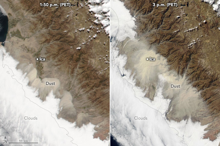
The MODIS (Moderate Resolution Imaging Spectroradiometer) on NASA’s Aqua satellite captured this image at about 3 p.m. Peru Time (PET) on July 31. The dust engulfed several urban areas, including Ica, a city in the coastal desert area of central Peru located about 300 kilometers (190 miles) south of Lima.
Winds in Ica that day reached almost 40 kilometers (25 miles) per hour, according to Senamhi, Peru’s national meteorological service. High winds and dust plumes also hit several coastal areas south of this scene, including Tacna, which lies near the border with Chile.
The winds, known locally as Paracas winds, occur in the region several times each year, typically in the afternoon hours toward the end of the austral winter. They are usually associated with the strengthening of anticyclonic conditions. In this case, the unusually strong South Pacific high-pressure front collided with a low-pressure system, producing strong downdrafts that stirred up the dust, according to news reports.
“The impact is local because the dust is being pushed against the Andes,” said Santiago Gassó, a University of Maryland atmospheric scientist. “The mountains are so high that the dust cannot go beyond, thus preventing long-range transport over the rest of the continent.”
Gassó pointed out that Aqua now observes locations on Earth later in the afternoon than it did several years ago. That’s because, due to fuel limitations, the 23-year-old satellite is slowly drifting to later equatorial crossing times and lower altitudes. As such, Aqua now captures phenomena it might not have otherwise observed—including Peru’s late-afternoon dust storm.
The image above shows the Aqua image (right), along with an image acquired 70 minutes earlier that day (left) by the VIIRS (Visible Infrared Imaging Radiometer Suite) on the NOAA-20 satellite. Together, the images emphasize how quickly the dust spread inland.
References & Resources
- AFP News Agency via X (2025, August 1) Sand and dust storm sweeps across southern Peru. Accessed August 4, 2025.
- Briceño-Zuluaga, F., et al. (2017) Paracas dust storms: Sources, trajectories and associated meteorological conditions. Atmospheric Environment, 165, 99-110.
- Senamhi via X (2025, July 31) Costa sur: levantamientos de polvo y arena se observa en las imágenes de satélite. Accessed August 4, 2025.
- The Watchers (2025, August 2) Unprecedented dust storm sweeps across Ica Valley, Peru. Accessed August 4, 2025.
NASA Earth Observatory images by Wanmei Liang , using MODIS data from NASA EOSDIS LANCE and GIBS/Worldview and VIIRS data from NASA EOSDIS LANCE , GIBS/Worldview , and the Joint Polar Satellite System (JPSS). Story by Kathryn Hansen.


