![Request for Information – Potential [Placeholder for Prize]](https://assets.science.nasa.gov/dynamicimage/assets/science/psd/solar/2023/09/s/solarsystem_0.jpg?w=1024)


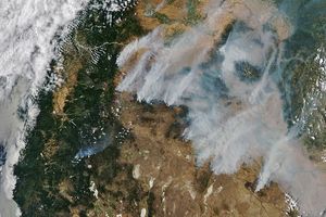
Hundreds of lightning-triggered forest fires burned across California during the first week of summer 2008. Northern California was hardest hit, with fires in many of the state’s large national forests. This natural-color image of the state was captured by the Moderate Resolution Imaging Spectroradiometer (MODIS) on NASA’s Aqua satellite on Monday, June 23, 2008. Places where the sensor detected actively burning fires are outlined in red. The fires are considerably smokier than they were the day before. The large version of the image shows additional fires burning farther south, including a large fire south of Salinas and another near Yosemite.
The high-resolution image provided above is at MODIS’ maximum spatial resolution (level of detail) of 250 meters per pixel. The MODIS Rapid Response Team provides twice-daily images of the region in additional resolutions and formats, including an infrared-enhanced version that highlights burned ground. You can also download a 250-meter-resolution kmz file of the image for use in Google Earth.
References & Resources
NASA image by Jeff Schmaltz, MODIS Rapid Response Team. Caption by Rebecca Lindsey.