


![Request for Information – Potential [Placeholder for Prize]](https://assets.science.nasa.gov/dynamicimage/assets/science/psd/solar/2023/09/s/solarsystem_0.jpg?w=1024)


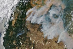
On May 1, 2006, scores of fires were burning in the West African country of Guinea. Some burning stretched northwest across the border into Guinea-Bissau, as well. This image of the area was captured by the Moderate Resolution Imaging Spectroradiometer (MODIS) on NASA’s Aqua satellite. Places where the sensor detected actively burning fires are marked in red. December through May is the country’s dry season. It is likely that most of the fires are agricultural fires that people are using to prepare farmland or pasture for the upcoming growing season; however, in the dry conditions, it is possible that some of the fires are accidental.
The high-resolution image provided above has a spatial resolution of 250 meters per pixel. The MODIS Rapid Response Team provides daily images of the area in a variety of resolutions and formats.
References & Resources
NASA image courtesy the MODIS Rapid Response Team, Goddard Space Flight Center.


