![Request for Information – Potential [Placeholder for Prize]](https://assets.science.nasa.gov/dynamicimage/assets/science/missions/a-step/FFR_Earth_Background_20251120%20.png?w=1024)


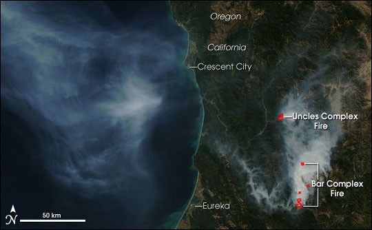
Two fire complexes were burning in northern California on September 24, 2006, when the Moderate Resolution Imaging Spectroradiometer (MODIS) on NASA’s Aqua satellite passed overhead and captured this image. The forested mountains appear deep green, while bright smoke traces the course of rivers and streams. Places where MODIS detected actively burning fires are marked in red. To the south is the Bar Complex Fire, which was 79,690 acres and 39 percent contained as of September 25, according to the daily report from the National Interagency Fire Center. To the north, the Uncles Complex was about 25,185 acres and 50 percent contained. The smoke from the fires hangs over the Pacific Ocean in the western half of the image.
The high-resolution image provided above has a spatial resolution of 250 meters per pixel. The MODIS Rapid Response Team provides daily images of the area in a variety of resolutions and formats.
References & Resources
NASA image courtesy the MODIS Rapid Response Team, Goddard Space Flight Center.