![Request for Information – Potential [Placeholder for Prize]](https://assets.science.nasa.gov/dynamicimage/assets/science/psd/solar/2023/09/s/solarsystem_0.jpg?w=1024)


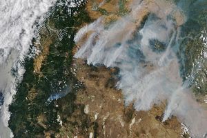
In South America, scores of fires (locations marked in red) were churning out thick smoke into the skies above Bolivia and Brazil on August 21, 2006. Different landscapes are burning in the scene, and the fires could have different causes in different places. In the top part of the scene, deep green forests are broken by tan-colored clearings, likely agricultural lands cleared out of the rainforest. Fires in the clearings may be intentional fires people have set to clear pasture or farmland. The smokier, more intense fires along the margins of the clearings could be fires set to clear rainforest for new fields or pastures, or they could be accidental fires that spread into the forest from agricultural lands.
In southern Bolivia, the landscape has a dull brown appearance; this region is known as the Gran Chaco, a dry, hot region. Compared to the intact rainforest regions farther north, the open woodland and grassy landscapes of the Gran Chaco are much more prone to naturally occurring (lightning-triggered) fires. Whether the fires seen in the Gran Chaco at the time of this image are naturally occurring or human-caused is not something MODIS can determine.
The high-resolution image provided above has a spatial resolution of 250 meters per pixel.
References & Resources
NASA image created by Jesse Allen, Earth Observatory, using data provided courtesy of the MODIS Rapid Response Team.