![Request for Information – Potential [Placeholder for Prize]](https://assets.science.nasa.gov/dynamicimage/assets/science/psd/solar/2023/09/s/solarsystem_0.jpg?w=1024)


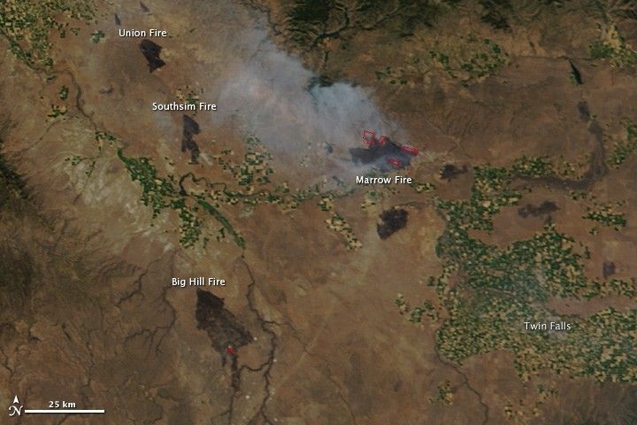
Lightning ignited several fires in southwestern Idaho on August 14, 2011. The fires burned quickly through brush and grass, consuming 137,000 acres by August 16. On average, 37,000 acres burn this time of year in southwestern Idaho.
This image, taken by the Moderate Resolution Imaging Spectroradiometer (MODIS) on the Terra satellite on August 16, shows both actively burning fires, outlined in red, and fresh burn scars. The newly burned land is charcoal black. The smokiest fire in this image, the Marrow Fire, was among the smaller fires in this outbreak, said the Bureau of Land Management. It burned 1,207 acres. By contrast, the largest fire, Bill Hill, burned 67,000 acres.
In all, the Boise District of the Bureau of Land Management responded to 14 wildfires in western Idaho between August 14 and August 16. Most have been contained, including all of the fires shown here: Big Hill, Marrow, Southsim, and Union.
References & Resources
- InciWeb. (2011, August 16). Boise wildfires burn nearly 137,000 acres since Sunday. Accessed August 17, 2011.
NASA image courtesy Jeff Schmaltz, MODIS Rapid Response Team at NASA GSFC. Caption by Holli Riebeek.