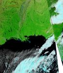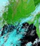























At the end of October 2009, a slow-moving storm dropped 3 to 6 inches (8 to 15 centimeters) of rain on Arkansas, just west of the Mississippi River. By early November, the Mississippi River ran roughly 30 feet (9 meters) above its average autumn water level, reported The Natchez Democrat.
The Moderate Resolution Imaging Spectroradiometer (MODIS) on NASA’s Aqua satellite captured these images of Arkansas and Tennessee on November 1, 2009 (top), and October 25, 2009 (bottom). Both images use a combination of infrared and visible light to increase the contrast between water and land. Vegetation appears bright green, clouds vary in color from pale blue to turquoise, and water ranges in color from electric blue to navy. In the image acquired on November 1, the most conspicuous feature is the swollen White River, the Mississippi tributary flowing past the cities of Newport and Des Arc. Areas of standing water also occur east of the White River.
References & Resources
- Hogan, V. (2009, November 3). Fall floods coming? The Natchez Democrat. Accessed November 4, 2009.
NASA image courtesy MODIS Rapid Response Team, Goddard Space Flight Center. Caption by Michon Scott.