


.png?w=1024)


August 28, 2011
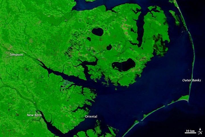
Flooding in North Carolina after Hurricane Irene
Hurricane Irene came ashore near Cape Lookout, North Carolina, on August 27, 2011. The storm brought heavy rains, flooding many parts of the state. After the storm moved northward along the Eastern Seaboard, high water lingered.
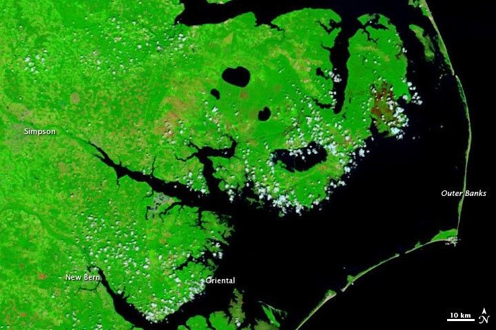
The Moderate Resolution Imaging Spectroradiometer (MODIS) on NASA’s Terra satellite captured these images on August 28, 2011 (top), and August 16, 2011 (bottom). These images use a combination of visible and infrared light to better distinguish between water and land. Water is navy blue. Vegetation is green, and bare ground, including burn scars, is earth-toned. Clouds are pale blue-green.
The biggest difference between these images is the amount of standing water apparent on August 28, especially east and northeast of Simpson. Twelve days earlier, these areas had been dry. Trees can easily hide standing water from the satellite sensor’s view, so flooding shows up best in areas where the forest has burned or been cleared. Flooding may be more extensive than this image shows.
A close look at these images reveals another difference along the Outer Banks. Tan-colored sandy areas, particularly east of Oriental, can be discerned on August 16. On August 28, those areas are blue, indicating that the sand is either saturated or flooded.
According to the News Observer, floods stranded dozens of families near the town of Oriental, and severe flooding occurred around the city of New Bern. Serious flooding also struck parts of the Outer Banks. The Weather Channel reported that Highway 12 had been compromised in several places.
The Advanced Hydrological Prediction Service (AHPS) of the U.S. National Weather Service reported flooding along the Chicod Creek near Simpson, as well as varying degrees of flooding in other locations. The North Carolina state health director warned residents that water in public systems and wells might be unsafe to drink, and multiple public water systems issued boil advisories.
References & Resources
- National Weather Service. Advanced Hydrologic Prediction Service. Accessed August 29, 2011.
- News Observer. (2011, August 30). Death toll is four in N.C.; flooding severe; curfews in force. Accessed August 30, 2011.
- North Carolina Department of Crime Control and Public Safety. (2011, August 29). North Carolina health officials concerned about food and water safety following Hurricane Irene. Accessed August 30, 2011.
- The Weather Channel. (2011, August 29). North Carolina: Extensive flooding and wind damage. Accessed August 29. 2011.
NASA images courtesy MODIS Rapid Response Team, Goddard Space Flight Center. Caption by Michon Scott.


