Suggested Searches

1 min read

Flooding in Northern India

Instruments:
Topics:
October 9, 2011
November 5, 2005
Acquired October 9, 2011, and November 5, 2005, these false-color images compare conditions in India’s Bihar Province, which experienced serious flooding in 2011.
NASA Earth Observatory image created by Jesse Allen and Robert Simmon, using EO-1 ALI data provided courtesy of the NASA EO-1 team and Landsat 5 TM data courtesy of the United States Geological Survey. Caption by Michon Scott.
October 9, 2011
November 5, 2005

October 9, 2011

Flooding in Northern India

Acquired October 9, 2011, and November 5, 2005, these false-color images compare conditions in India’s Bihar Province, which experienced serious flooding in 2011.
Flooding in Northern India
Acquired October 9, 2011, and November 5, 2005, these false-color images compare conditions in India’s Bihar Province, which experienced serious flooding in 2011.
NASA Earth Observatory image created by Jesse Allen and Robert Simmon, using EO-1 ALI data provided courtesy of the NASA EO-1 team and Landsat 5 TM data courtesy of the United States Geological Survey. Caption by Michon Scott.

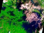
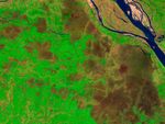
In early October 2011, flooding struck the Indian province of Bihar, drowning villages, destroying roads, and claiming lives. On October 9, 2011, the Advanced Land Imager (ALI) on NASA’s Earth Observing-1 (EO-1) satellite captured the top image showing part of Bihar Province. For comparison, the bottom image shows the same area as observed by the Thematic Mapper on the Landsat 5 satellite on November 5, 2005.

In these false-color images, vegetation is bright green, water is blue, bare ground is earth-toned, and clouds are pale pink. In 2005, water is confined to a few river channels, and most of the area is dry. Six years later, water swells rivers and fills floodplains, particularly in the east.

References & Resources

NASA Earth Observatory image created by Jesse Allen and Robert Simmon, using EO-1 ALI data provided courtesy of the NASA EO-1 team and Landsat 5 TM data courtesy of the United States Geological Survey. Caption by Michon Scott.

You may also be interested in:

Stay up-to-date with the latest content from NASA as we explore the universe and discover more about our home planet.

Iraq Reservoirs Plunge to Low Levels
5 min read

A multi-year drought has put extra strain on farmers and water managers in the Middle Eastern country.

Article
Reservoirs Dwindle in South Texas
3 min read

Drought in the Nueces River basin is reducing reservoir levels, leaving residents and industry in the Corpus Christi area facing…

Article
Monsoon Rains Flood Pakistan
3 min read

Heavy rains and flooding across the country since June 2025 have displaced millions of people, devastated infrastructure, and submerged farmland.

Article