In March 2016, the Southern United States received a remarkable amount of precipitation. In the days after the slow-moving weather system cleared out, flood waters rose across several major river basins.
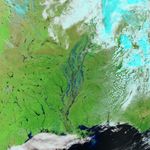
On March 14, 2016, the Moderate Resolution Imaging Spectroradiometer (MODIS) on NASA’s Terra satellite captured an image of flooding in the vicinity of the Mississippi and White rivers. The image is false color, composed from a combination of infrared and visible light (MODIS bands 7-2-1). Flood water appears dark blue; saturated soil is light blue; vegetation is bright green; and bare ground is brown. This band combination makes it easier to see flood water.
The flooding was the result of an unusually strong low-pressure system that pulled in atmospheric moisture from both the Western Caribbean and the Eastern Pacific, according to meteorologists at Weather Underground. The system stalled over the southern states, and rainfall totals amounted to what would be expected to occur once every 200 years.
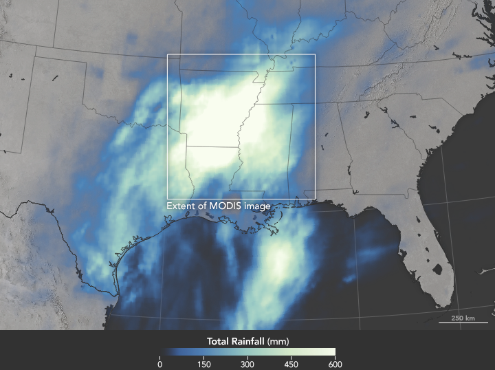
The map above shows NASA’s satellite-based estimates of rainfall over the Southern United States and the Gulf of Mexico from March 7–14. The brightest shades represent rainfall totals approaching 600 millimeters (24 inches) over the span of a week. The rainfall data represented in the map come from the Integrated Multi-Satellite Retrievals for GPM (IMERG), a product of the Global Precipitation Measurement mission. These regional, remotely sensed estimates may differ from the totals measured by ground-based weather stations.
According to news reports, rain and flooding in the United States affected communities in Texas, Oklahoma, Arkansas, Louisiana, Mississippi, Tennessee, Alabama, and Kentucky. In Louisiana alone, the flooding was reported to have killed four people and damaged at least 5,000 homes.
References & Resources
- Reuters (2016, March 15) Five dead in storms in U.S. Southern states as flooding continues. Accessed March 15, 2016.
- The Weather Channel (2016, March 10) 3 Dead, Thousands Evacuated as Historic Flooding Swamps Louisiana. Accessed March 15, 2016.
- Weather Underground, WunderBlog (2016, March 11) Floods From up to 20 Inches of Rain Create State of Emergency in Louisiana. Accessed March 15, 2016.
- Weather Underground, WunderBlog (2016, March 10) Record-Strength Upper Low Brings Extreme Rains to South U.S., Thundersnow to Mexico. Accessed March 15, 2016.
NASA Earth Observatory image (top) by Jesse Allen, using data from the Land Atmosphere Near real-time Capability for EOS (LANCE). NASA Earth Observatory image (bottom) by Joshua Stevens, using IMERG data provided courtesy of the Global Precipitation Mission (GPM) Science Team's Precipitation Processing System (PPS). Caption by Kathryn Hansen.