


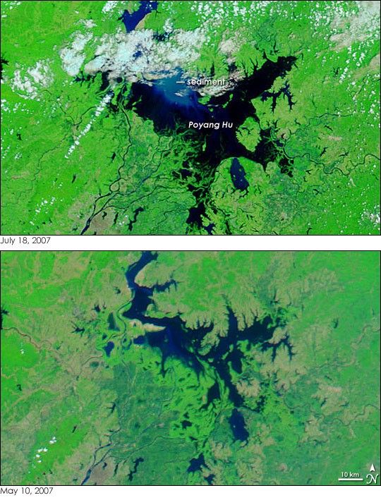
- July 18, 2007 (3.43 MB JPG)
- May 10, 2007 (2.18 MB JPG)
Unusually heavy summer rains led to widespread flooding across central China in June and July 2007. On July 18, the Moderate Resolution Imaging Spectroradiometer (MODIS) on NASA’s Terra satellite captured the top image of the flood-swollen Poyang Hu (Hu is Chinese for “lake”) in China’s southern Jiangxi Province. The lake is the largest fresh-water lake in China, but its size fluctuates seasonally. During the summer rainy season, Poyang Lake can be more than 1,000 square kilometers larger than its dry-season extent. By July 18, the lake was certainly much larger than it had been on May 10, when Aqua MODIS acquired the lower image. In these images, made with a combination of infrared and visible light, water is dark blue or black. Sediment lightens the color of the water. The land around the lake is covered in bright green vegetation spotted with silvery-gray cities. Bare or sparsely vegetated land is tan, and clouds are white and pale blue.
The annual flooding on Poyang Lake begins with the southern rainy season during the late spring, and culminates during the summer rains along the Yangtze. For most of the year, the lake drains into the Yangtze River through a channel on its northern shore, but during the mid- to late-summer, the Yangtze runs high, and water flows from the Yangtze into Poyang Lake. The top image reveals that this reversal in flow has probably already started. A plume of dusty blue sediment—a sign of flooding—flows into Poyang Lake from the wide channel that leads to the Yangtze River in the north.
As of July 16, more than 105 million people had been affected by flooding throughout China since mid-June, with 3.6 million evacuated from their homes, said the International Federation of Red Cross and Red Crescent Societies (IFRC). In mid-July, the most severe flooding occurred on the Huai River, north of Poyang Lake. Daily images of Poyang Lake are available from the MODIS Rapid Response System.
- Shankman, D., Keim, B. (2006). Flood frequency in China’s Poyang Lake region: trends and teleconnections. International Journal of Climatology, 26: 1255-1266.
References & Resources
NASA image courtesy the MODIS Rapid Response Team at NASA GSFC.


