


December 5-7, 2020
Fraser Island Blazes
In October 2020, a campfire ignited a bushfire near the north end of Australia’s Fraser Island. Over the course of two months, the fire spread widely, scorching half of the World Heritage Site and threatening local wildlife.
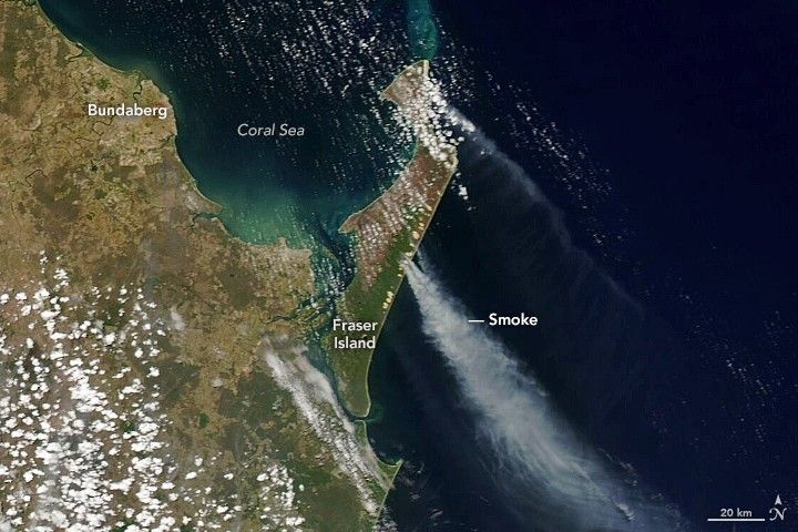
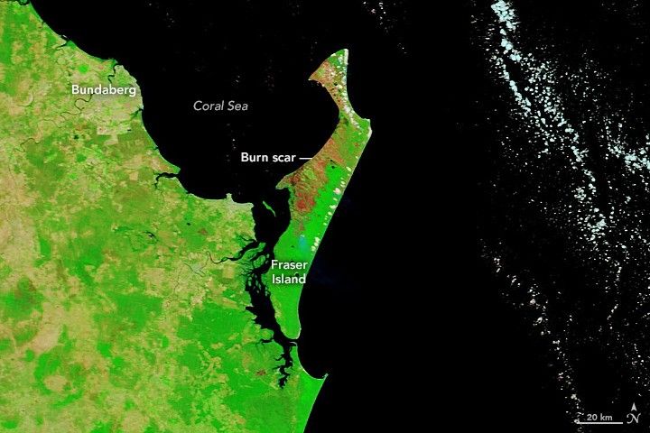
The images above show Fraser Island in early December 2020. The false-color image (left) shows the burn scar on December 5 as observed by the Moderate Resolution Imaging Spectroradiometer (MODIS) on NASA’s Terra satellite. The false-color image uses a combination of visible and infrared light (MODIS bands 7,2,1) to better distinguish the burn scars. Burned vegetation appears brown or deep orange and unburned vegetation appears bright green. The natural-color image (right) shows smoke plumes rising from the eastern side of the island on December 7, as observed by MODIS on board NASA’s Aqua satellite.
Spanning 180,000 hectares (440,000 acres), Fraser Island (also called K’gari) is known for its tropical rainforests, sand dunes, and inland lakes. It is home to wild dingoes and several rare plant species. It is also the world’s largest sand island with over 250 kilometers (160 miles) of sandy beaches and more than 40 kilometers (25 miles) of sand cliffs. About 100 people live on the island, though hundreds of thousands of tourists visit the beaches each year.
Since October 14, fires have burned more than 80,000 hectares (200,000 acres) on the island. More than 100 firefighters are battling the blazes, trying to keep them away from homes and businesses. Residents of Happy Valley township (on the eastern side of the island) and staff and tourists at local resorts were told on December 7 to be ready to evacuate.
Dry conditions, including a record-breaking heat wave in late November, have helped fire spread across dense bushland areas over the past seven weeks. On December 8, about 26 millimeters (1 inch) of rain fell on the island and slowed but did not extinguish the fires.
Scientists say the burnt forest could regenerate quickly. Most of the island is comprised of sclerophyll vegetation—small plants with tough leaves adapted to fire. However, the temporary loss of vegetation will affect the food chain in the meantime. Plant-eating insects will suffer and starve, affecting animals that depend on them as a food source, such as birds, echidnas, and dingoes.
References & Resources
- ABC News (2020, December 8) Rain provides relief to Fraser Island firefighting efforts but âtrickyâ conditions predicted to come. Accessed December 9, 2020.
- ABC News (2020, December 2) Fraser Island bush will regenerate despite fire scorching half of World Heritage-listed site, scientists say. Accessed December 9, 2020.
- The Conversation (2020, December 8) The Kâgari-Fraser Island bushfire is causing catastrophic damage. What can we expect when itâs all over? Accessed December 9, 2020.
- Gold Coast Bulletin (2020, December 9) Shocking pictures of fire-ravaged Fraser Island scorched by eight-week blaze. Accessed December 9, 2020.
- Queensland Government Fire and Emergency Services (2020, December 8) PREPARE TO LEAVE: Kingfisher Bay Resort and Village (part of Kâgari, Fraser Island bushfire) as at 9am Mon 7 Dec. Accessed December 9, 2020.
- UNESCO World Heritage Fraser Island. Accessed December 9, 2020.
NASA Earth Observatory images by Lauren Dauphin, using MODIS data from NASA EOSDIS/LANCE and GIBS/Worldview . Story by Kasha Patel.


