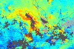

Fires burning across the island of Sumatra produced a significant amount of pollution in February 2005. Because one of the by-products of combustion is carbon monoxide, the gas is a good tracer of fire-induced pollution. In February, high levels of carbon monoxide hung over Sumatra and Malaysia. This false-color image shows the concentrations of carbon monoxide at an altitude of roughly 3 kilometers (700 millibars) in the atmosphere. The data were collected by the Measurements Of Pollution In The Troposphere (MOPITT) instrument aboard NASA's Terra satellite from February 13 to February 23, 2005.
The red pixels in this image show the highest concentrations of carbon monoxide, and blue pixels show the lowest concentrations. The gray shaded areas show where no data were collected due to persistent cloud cover.
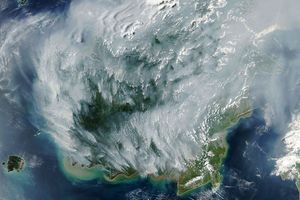
The mingling of smoke with cloud over Sumatra is captured in related imagery from the Moderate Resolution Imaging Spectroradiometer
from
References & Resources
NASA image created by Jesse Allen, Earth Observatory, using data provided courtesy of the NCAR and University of Toronto MOPITT Teams