


![Request for Information – Potential [Placeholder for Prize]](https://assets.science.nasa.gov/dynamicimage/assets/science/psd/solar/2023/09/s/solarsystem_0.jpg?w=1024)


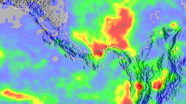
Beginning on November 22, 2006, a major stationary front (boundary between two air masses with different characteristics) released very heavy, sustained rain over Central Panama, flooding the Rio Indio to the west of Lago Gatun and the Panama Canal. The floods caused at least eight deaths, collapsed bridges, and cut off communities, reported The Washington Post. This image shows the intense rainfall that generated the floods. The analysis was produced by the Multi-satellite Precipitation Analysis project at NASA’s Goddard Space Flight Center, based in part on observations from the Tropical Rainfall Measuring Mission (TRMM) satellite collected between November 20 and November 28, 2006. The rain fell in fell in a classic “bull’s-eye” pattern, with progressively lighter rainfall radiating out from the heaviest rainfall (shown in darker red). The heaviest rain is centered over the Rio Indio watershed west of the Panama Canal. Similarly high rainfall totals for the period are centered over the Caribbean and northern Colombia.
Swollen rivers, roiling with mud from runoff and landslides, dumped a plume of sediment into the Caribbean, which can be seen sweeping eastward from the flood region in a photo-like satellite image taken by the Moderate Resolution Imaging Spectroradiometer (MODIS) on NASA’s Aqua satellite on November 26, two days after flooding was first reported. Sediment colors the ordinarily dark water aquamarine. Sediment plumes derived from numerous small rivers along the southern (Pacific) side of the isthmus and the Archipelago de Las Perlas are also visible.
References & Resources
TRMM image courtesy Hal Pierce (SSAI/NASA GSFC), caption information courtesy Timothy Gubbels (SSAI) and SERVIR .


