![Request for Information – Potential [Placeholder for Prize]](https://assets.science.nasa.gov/dynamicimage/assets/science/psd/solar/2023/09/s/solarsystem_0.jpg?w=1024)


September 1, 2011
High Cascades Complex, Oregon
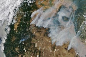
A lightning storm started this cluster of wildfires in the CascadeMountains of Oregon on August 24, 2011. Burning through forest, grass, andbrush, the fires had covered 90,436 acres as of September 1. They are 25percent contained.
The Moderate Resolution Imaging Spectroradiometer (MODIS) on NASA’s Aqua satellite acquired these images onSeptember 1. The fires, collectively called the High Cascades Complex areoutlined in red. The top image shows the region in natural color, similar towhat the human eye sees. In this image, smoke hangs over the CascadeMountains. Newly burned land is dark brown, similar in tone to the naturalland cover in the desert east of the dark green mountains.
The lower image combines infrared and visible light in a false colorimage that reveals the extent of the recently burned area. Here, freshlyburned land is red, while plant-covered land is green, and bare or sparselyvegetated land is tan. In this scene, the Razorback and Hancock Complexfires are more obvious. The Razorback Fire is the largest fire in the HighCascades Complex, having burned 51,943 acres as of September 1. The Hancock Complex burned57,597 acres of grass and is entirely contained. All of the fires started inthe same lightning storm on August 24.
References & Resources
- InciWeb. (2011, September 2). Hancock Complex. AccessedSeptember 2, 2011.
- InciWeb. (2011, September 1). High Cascades Complex.Accessed September 2, 2011.
NASA images courtesy the MODIS Rapid Response Team at NASA GSFC. Caption by Holli Riebeek.