


March 20, 2018-March 16, 2019
Historic Floods Inundate Nebraska

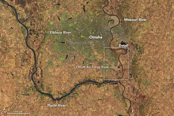
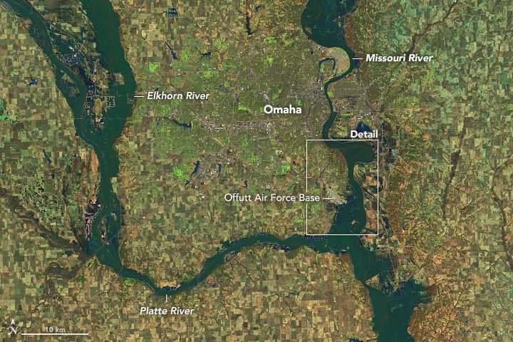
In the wake of an intense winter storm, historic floods have broken out across the central United States. By mid-March, several streams and rivers had risen to all-time record levels in Nebraska, Iowa, South Dakota, and Wisconsin.
Nebraska has been particularly hard hit. On March 16, 2019, the Operational Land Imager (OLI) on Landsat 8 captured a false-color image that underscores the extent of the flooding on the Platte, Missouri, and Elkhorn Rivers. For comparison, the second image shows the same area in March 2018.
Several communities west of Omaha (between the Elkhorn and Platte Rivers) either flooded or temporarily became islands as floodwaters encroached from both sides. One third of Offutt Air Force Base was inundated and 30 buildings were damaged, according to news reports. Rising flood waters forced people in dozens of communities to evacuate.
A rare confluence of circumstances produced the flooding. Extreme cold earlier in the winter set the stage by preserving a significant amount of snow; it also created a thick layer of ice on waterways and made the ground less permeable than usual. When an intense storm brought downpours and unusually warm air to the region in March, it rapidly melted much of the snow and ice, producing enormous runoff in a short period. As river ice broke up, large chunks compounded the problem by slamming into dams, raking against levees and other infrastructure, and packing together to jam waterways even more.
References & Resources
- National Weather Service (2019, March 18) River Gauges. Accessed March 18, 2019.
- National Weather Service (2019, March 18) Flood Warning. Accessed March 18, 2019.
- Omaha World-Herald (2019, March 17) Record snowfall, âhistoricâ bomb cyclone are forces behind Nebraska floods, blizzard. Accessed March 18, 2019.
- Omaha World-Herald (2019, March 18) Live Updates. Accessed March 18, 2019.
- The Washington Post (2019, March 18) These images unmask the historic and horrific flooding in Nebraska and nearby states. Accessed March 18, 2019.
- The Weather Channel (2019, March 18) Historic Flooding in Nebraska, Iowa, Kills 3, Cuts Off Entire Towns, Ruins 500 Homes in One County Alone. Accessed March 18, 2019.
NASA Earth Observatory images by Joshua Stevens, using Landsat data from the U.S. Geological Survey. Story by Adam Voiland.


