


- August 13, 4:32 UTC (600 KB)
- August 13, 21:05 UTC (700 KB)
The state of Florida has suffered its second direct hit by a tropical cyclonein as many days. On Thursday August 12, 2004, Bonnie came ashore in theFlorida panhandle near Apalachicola as a tropical storm. Charley, however,became far a more dangerous Category 4 storm before it slammed into the southwestcoast of Florida. Just as it did with Bonnie, the Tropical Rainfall MeasuringMission (TRMM) satellite followed Charley's progress across the Caribbean andCuba, which suffered a direct hit. The images and data collected by TRMM canprovide valuable estimates of storm location and storm intensity to the NOAATropical Prediction Center (also known as the National Hurricane Center).
Similar to Bonnie, Charley began as a tropical depression near the WindwardIslands. Tropical depression number three (TD #3) formed on August 9th, 2004just to the southeast of Grenada. TD #3 then moved west-northwest into thelower eastern Caribbean and strengthened into a tropical storm on the morning(local time) of the 10th. The image shown above was taken at 05:43 UTC (1:43 am EDT)on 10 August 2004. The image displays the horizontal distribution of rainintensity obtained from the TRMM satellite. Rain rates in the center part ofthe swath are from the TRMM Precipitation Radar (PR), the first and onlyprecipitation radar in space. The PR can provide fine resolution rainfall dataand details on the vertical structure. Rain rates in the outer swath are fromthe TRMM Microwave Imager (TMI). The rain rates are overlaid on infrared (IR)data from the TRMM Visible Infrared Scanner (VIRS). The image shows Charleyjust before it became a named tropical storm. The storm appears rather smallwith no apparent banding in the rain field. But, most of the rain (greenmoderate and blue light) is concentrated near the center and IR data (whitebackground) indicates that there is good outflow with the storm.
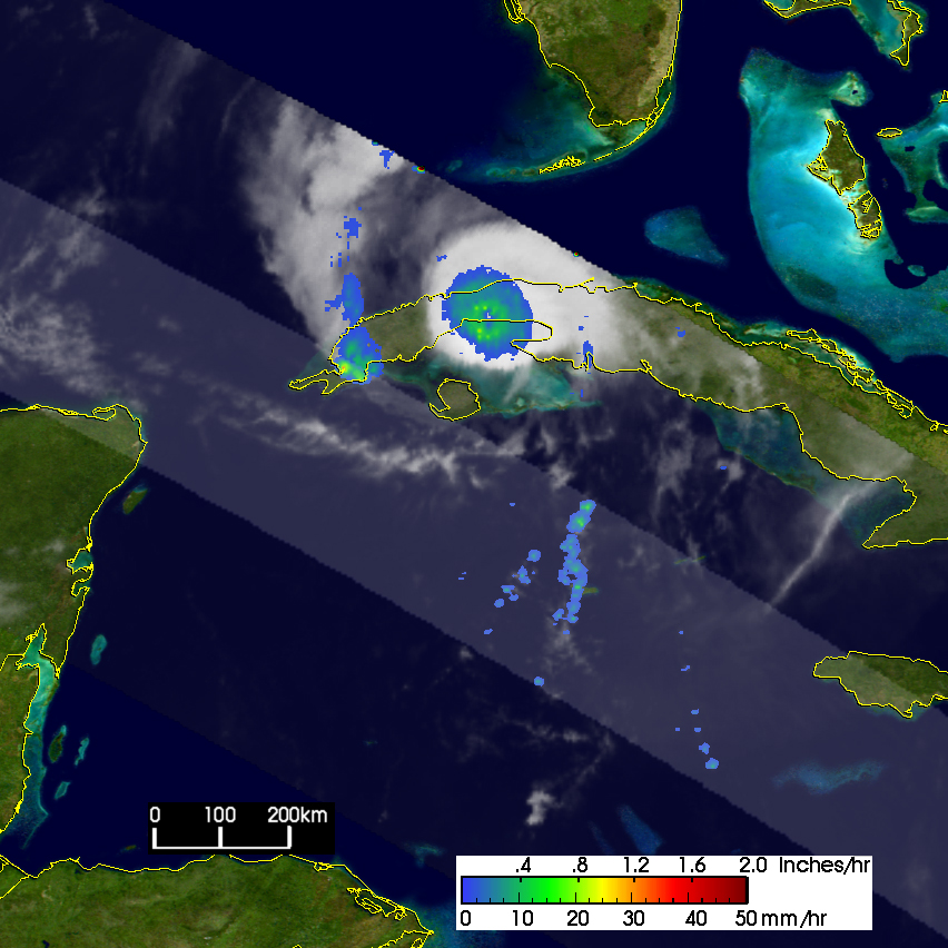
Charley continued moving west-northwest into the central Caribbean and slowlystrengthened into a minimal Category 1 hurricane on the afternoon (local time)of the 11th with maximum sustained winds reported at 65 knots (75 mph) based onmeasurements by an Air Force Reserve Hurricane Hunter Aircraft. At this point,Charley was just south of Jamaica. The storm now began to curve towards theright taking a more northwestward track as it passed around the western sideof a subtropical ridge to its north. Charley continued to slowly intensify.Early on the afternoon of the 12th (local time), Charley became a Category 2hurricane with sustained winds of 85 knots (98 mph). Charley then turnedeven more to the north ahead of an upper-level trough and headed straight forwestern Cuba. On the evening of the 12th of August, Charley passed just tothe east of the Isle of Youth and slammed into western Cuba where it crossedthe island just west of Havana before emerging into the southeastern Gulf ofMexico. The image taken at 04:32 UTC (12:32 am EDT) on Friday August 13shows Charley directly over Cuba. The PR missed the center of the storm buta perfectly symmetrical ring of moderate rain (green circle) marks the centerof Charley by the TMI. The rain field appears tightly concentrated near thecenter which is surrounded by an area devoid of rain known as a dry slotshowing where drier air has been entrained into the storm's circulation. Atthe time of this image, Charley's sustained winds were 90 knots (104 mph).After coming off of Cuba, Charley intensified into a powerful Category 4storm, with sustained winds measured at 145 mph, before slamming into thesouthwest coast of Florida near Captiva Island.
TRMM is a joint mission between NASA and the Japanese space agency JAXA.
References & Resources
Images produced by Hal Pierce (SSAI/NASA GSFC) and caption by Steve Lang (SSAI/NASA GSFC), NASA's Tropical Rainfall Measuring Mission.


