Hurricane Fabian is the first major hurricane of the 2003 Atlantic season. Fabian, known as a “Cape Verde” storm because of its origin in the easternAtlantic, became a depression on August 27 just west of the Cape Verde Islands after emerging off of the African coast as an easterly wave. It became a tropical storm on the August 28 before strengthening into ahurricane on the 29th. Fabian quickly gained strength, becoming a Category3 storm on August 30 and a Category 4 storm with winds estimated at 135 mph by the National Hurricane Center on the 31st.
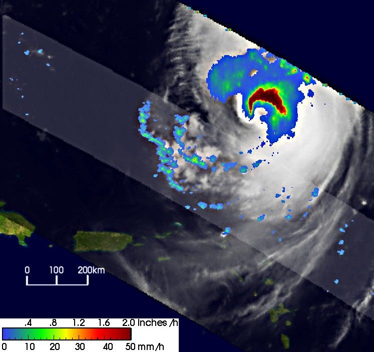
The Tropical Rainfall Measuring Mission (TRMM) satellite captured thisimage of Fabian north of the Leeward Islands at 09:58 UTC (5:48 a.m. AST) onthe September 3, 2003, as it was moving slowly toward the northwest. At the time Fabian was still classified as a powerful Category 4 storm. The image gives a top down view of the storm with rainfall rates from the TRMM Precipitation Radar (PR) in the inner swath and the TRMM Microwave Imager (TMI) in the outer swath overlaid on TRMM VisibleInfrared Scanner (VIRS) data (white areas). The image shows intense rain rates (darker red areas) around the western, northern, and eastern sides ofthe eyewall that are fueling the storm by releasing heat energy near thecore of Fabian. The VIRS data, however, do reveal that Fabian is feeling the effects of westerly wind shear aloft as evidenced by the restrictedcirrus outflow on the western half of the storm.
TRMM is a joint mission between NASA and the Japanese space agency NASDA.
References & Resources
Image produced by Hal Pierce (SSAI/NASA GSFC) and caption by Steve Lang (SSAI/NASA GSFC)